Watersheds
Muskingum With the Flow Report for the Week of June 5 to June 11, 2023
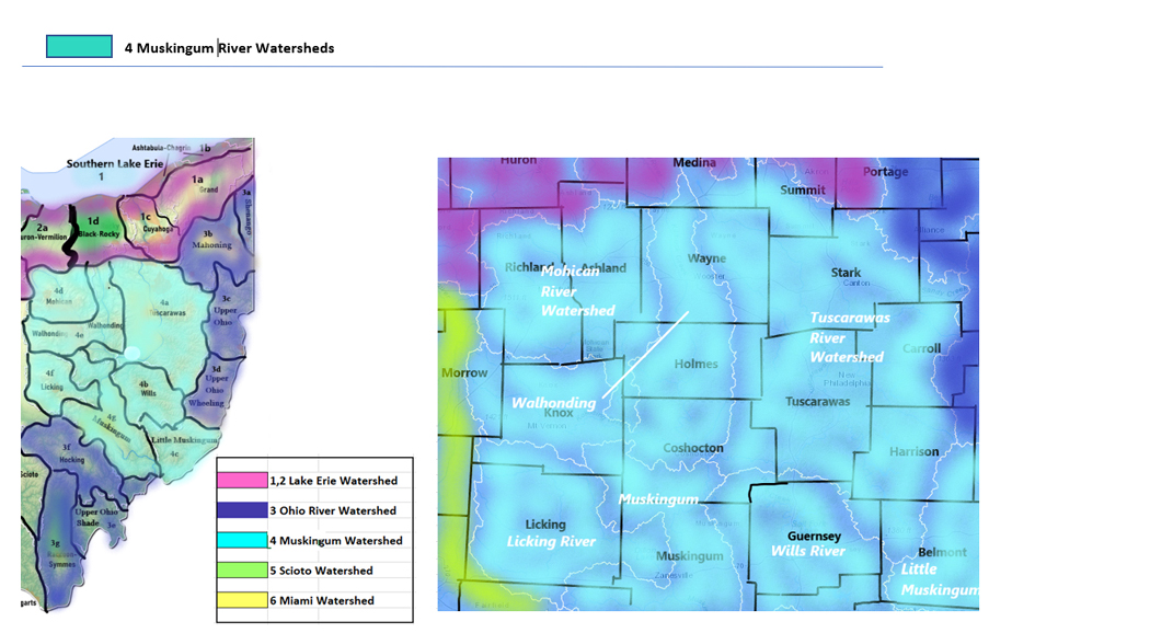
Find your location in the Muskingum River drainage basin. Impacts to water within the watersheds of the Muskingum basin may affect drinking water supplies for residents within the same watershed. Downstream impacts can reach the Ohio River, which is a source of drinking water for many Ohio populations including East Liverpool, Portsmouth and Cincinatti, cities and towns in Indiana and Kentucky. Downstream effects from flood or low flow will reach the Mississippi River, and large spill incidents or run-off from industry and agriculture can impact the drinking water supplies of communities through the Midwest and all the way to Louisiana and the Gulf of Mexico. Follow these events and incidents by watershed area.
|
Drainage Basin
Muskingum River
|
Low Flows
|
HABs
|
Drinking Water Advisories
|
Hazardous Spills
|
|
Tuscarawas River
|
1
|
0
|
3
|
2
|
|
Wills Creek
|
1
|
0
|
1
|
0
|
|
Little Muskingum
|
1
|
0
|
1
|
1
|
|
Mohican River
|
0
|
0
|
0
|
1
|
|
Walhonding River
|
2
|
0
|
3
|
0
|
|
Licking River
|
1
|
0
|
2
|
1
|
|
Muskingum River
|
2
|
0
|
2
|
0
|
|
Totals
|
8
|
0
|
12
|
5
|
Table updated June 12, 2023
4a Tuscarawas River Watershed
Events and conditions impacting water quality include parts of Tuscarawas, Stark, Wayne, Carroll, and Harrison Counties
Tuscarawas River drains an area of 2443 sq miles of Tuscarawas County before joining the Muskingum River. USGS flow monitoring stations are listed in order from headwaters to outlet
- above Barberton, flow is unrated, we see this station measuring flow at 3ft deep around 20 cubic feet per second (flood stage 13 ft)
-
- at Massillon, normal flow is around 400 cfs and 9 ft deep, (flood stage 18 ft)
- below Dover Dam near Dover, normal flow is 3.5 ft deep (flood stage 7.5 ft)
- at New Philadelphia, flow is not rated, we see this station measuring up around 2300 cfs and 2.6 ft deep (flood stage 7.5 ft)
- at Newcomerstown, normal flow is around 3800 cfs and 3.5 ft deep, (Flood stage 11ft)
Chippewa Creek drains an area of 50.4 sq miles of Wayne County. The flow at Miller Rd at Sterling is unrated, often seen around 80 cfs and 2.5 ft deep
(
drains an area of 311 sq miles in Tuscarawas County. The flow
- near Beach City, flow is unrated, often around 2 ft deep
- at Strasburg, normal flow is around 300 cfs and 2.8 ft deep
Nimishillen Creek drains an area of 172 sq miles in Stark County. Normal flow at North Industry is around 200 cfs and 4.3 ft deep (flood stage 10 ft)
Middle Branch Nimishillen Creek drains 43 sq miles in Stark County. Normal flow at Canton is around 40 cfs and 1.8 ft deep. (flood stage 6ft)
East Branch Nimishillen Creek drains an area of 15 sq miles in Stark County. The flow at Louisville is unrated, often around 4 ft deep (flood stage 11 ft)
West Branch Nimishillen Creek drains an area of 15.8 sq miles in Stark County. The flow at North Canton is unrated, commonly seed around 3 ft deep (flood stage 9 ft)
Sandy Creek drains an area of 253 sq miles in Stark County. Normal flow at Waynesburg is around 300 cfs and 2.3 ft deep (flood stage 8 ft)
Willow Run drains an area of 7.8 sq miles in Carroll County. The flow near Dellroy is unrated, often 2 ft deep, temp and conductance are measured here
McGuire Creek drains an area of 48.3 sq miles in Carroll County. The flow
- above Leesville Lake is unrated, we see it around 1.8 ft deep, temp and conductance are measured here
- near Leesville, normal flow is around 60 cfs and 3.5 ft deep
North Fork McGuire Creek drains an area of 11.3 sq miles of Carroll County. The flow at Carrollton is unrated, we see it at 3.7 ft deep, temp and conductance are measured here.
Indian Fork drains an area of 70 sq miles in Tuscarawas County. The flow
- at Dellroy is unrated, often 5.5 ft deep, temp and conductance are measured here
- below Atwood Dam near New Cumberland flow is likewise unrated, often around 90 cfs and 7 ft deep
Bear Hole Run drains an area of 1.43 sq miles in Carroll County. The flow near Carrollton is unrated, measuring close to 2 ft deep when conditions in the surrounding area are average, temp and conductance are measured here
Stillwater Creek drains an area of 367 sq miles in Tuscarawas and Harrison Counties
- above Piedmont Lake is unrated, we see it 2 ft deep and temp and conductance are measured here
- at Piedmont flow is unrated, commonly around 200 cfs and 3.2 ft deep
- at Tippecanoe is flow is unrated, around 450 cfs and up 6.5 ft deep
- at Uhrichsville, flow is unrated, usually around 6.5 ft deep (flood stage 10 ft)
Little Stillwater Creek drains an area of 71.1 sq miles of Harrison County. Flow below Tappan Dam at Tappan is unrated, a minor 10 to 15 cfs and 4 ft deep
Beaverdam Run /b>drains an area of 3.5 sq miles in Harrison County. The flow above Tappan Lake is unrated, under a foot deep, temp and conductance are measured here
Standingstone Fork drains an area of 13.5 sq miles of Harrison County. The flow above Tappan Lake is unrated, commonly 4 ft deep, temp and conductance are measured here
Boggs Fork drains an area of 36.6 sq miles in Harrison County. The flow at Piedmont is unrated, around 80 cfs and 4 ft deep.
Brushy Fork drains an area of 70 sq miles Harrison County
- above Clendening Lake flow is unrated, 3.2 ft deep, temp and conductance are measured here
- near Tippecanoe flow is unrated, around 120 cfs and 4.4 ft deep
Clear Fork drains an area of 23.3 square miles in Harrison County. Flow above Tappan Lake is unrated, common to see it 2ft deep, temp and conductance are measured here
Flows (3 low) June 12 11:00 am EDT
Tuscarawas River is flowing much below normal at Newcomerston - down overnight - running 1.01 ft deep at 622 cubic feet per second
Sandy Creek is flowing much below normal at Waynesburg - running 1.27 ft deep at 60.1 cubic feet per second
McGuire Creek is flowing much below normal at Leesville - down overnight - running 2.99 ft deep at 2.78 cubic feet per second
HABs (0)
Public Drinking Water Advisories (3) confirmed ongoing as of June 12, 2023
Resco Products Inc – East Canton (Stark) Boil Water Advisory issued by Ohio EPA for the confirmed presence of E.coli microbiological contamination in the water supply. This is a non-transient, non-community system serving less than 250 people from a groundwater source.
Glade Run Mennonite Church – Kensington ( Carroll County) Sensitive Population Advisory
Exceeds standards for inorganic chemical - fluoride
Children under nine should be provided with alternative sources of drinking water or water that has been treated to remove fluoride in order to lessen the risk of cosmetic discoloration of their permanent teeth
MCL = 4 mg/l and Secondary MCL = 2 mg/l
This is a non-transient system serving less than 250 people from a groundwater source
Legacy Christian School – Sugar Creek (Tuscarawas County) Do not consume advisory, sensitive populations issued by Ohio EPA
Lead exceeds standard
Lead poses the greatest risk to young children and pregnant women. The CDC recommends children and pregnant women use bottled water or water from a filtration system that has been certified by an independent testing organization to reduce or eliminate lead for cooking, drinking and baby formula preparation.
This is a non-transient, non-community system serving less than 250 people from a groundwater source
Spills (2)
- June 11 - unknown amount of white material reported spilled in Dover - Tuscarawas - Tuscarawas River affected *
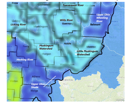
4b Wills Creek Watershed
Impacts to water in Wills Creek watershed move with the flow from the headwaters near Derwent and head northwest, gathering the runoff from parts of Licking, Guernsey and Tuscarawas Counties hooking south and joining up with the Muskingum River
Wills Creek drains an area of 406 sq miles in Guernsey County, making a northward run and looping back down into the Muskingum system. The flow
- at Derwent is not rated, 8 ft deep is common
- at Cambridge normal flow is around 750 cfs and 5.5 ft deep (flood stage 15ft)
- below Wills Creek Dam at Wills Creek, 6 ft deep
Seneca Fork drains an area of 118 sq miles in Guernsey County before joining Wills Creek. The flow below Senecaville Dam near Senecaville is not rated, is usually around 350 cfs and 6 ft deep.
South Fork drains an area of 28.3 sq miles in Noble County before entering Senecaville Lake. The flow above Senecaville Lake is unrated, 6.3 ft deep, temp and conductance are detected here
Beaver Creek drains an area of17 sq miles in Guernsey County before joining up with Wills Creek. The flow above Senecaville Lake is not rated, 4.5 ft deep, temp and conductance taken here
Leatherwood Creek drains an area of 69.5 sq miles in Guernsey County. The flow near Kipling is not rated, is often flowing around the 65 cfs mark and 3 ft deep.
Flows (1 low) June 12 11:00 am EDT
Wills Creek is flowing much below normal at Cambridge - down again overnight - flow depth is 1.73 ft at 10.2 cubic feet per second
HABs (0)
Public Drinking Water Advisories (1) confirmed ongoing as of June 12, 2023
Byesville Water System (Guernsey) Sensitive Population Advisory issued by Ohio EPA
Exceeds standards for Disinfection Byproducts – Trihalomethane - By-product of drinking water chlorination
Healthy individuals do not need to use bottled water, however, if you have specific health concerns, consult your doctor.
This is a community system serving 3, 301 to 10,000 persons from a groundwater source
Spills (0)
- *NEW June 9 - unknown amount of motor oil reported spilled in Valley Township – Guernsey
4c Little Muskingum River Watershed
The Little Muskingum River flows in its own channel to the Ohio River within the larger Muskingum River watershed, taking in the runoff from parts of Washington, Noble, Monroe, Guernsey counties. Spills that occur in this watershed can impact drinking water supplies downstream in the same watershed and very mobile contaminants released in the waterways can reach the Ohio River, a source of drinking water for several Ohio cities and towns.
Little Muskingum River drains an area of 210 sq miles of Washington County; normal flow at Bloomfield is 425 cfs and 4.5 ft deep.
Duck Creek drains an area of 260 sq miles in Washington County. The flow below Whipple is unrated, around 400 cfs and 3 ft deep (flood stage 12 ft)
East Fork Duck Creek drains an area of 99.5 sq miles in Noble County. Flow near Harrietsville not rated, around 150 cfs and 4.5 ft deep, (flood stage 17 ft)
West Fork Duck Creek drains an area of 84.5 sq miles in Washington County. The flow at Macksburg is not rated, is often around 120 cfs and 7 ft deep (flood stage 13 ft)
Flows (1 low) June 12 11:00 am EDT
Little Muskingum River is flowing much below normal at Bloomfield - down overnight - flow depth is 2.49 ft at 5.79 cubic feet per second
HABs (0)
Public Drinking Water Advisories (2) confirmed ongoing as of June 12, 2023
*NEW June 9 – Marietta (Washington) Boil Water Advisory issued by the City of Marietta for customers on Merryhill Street, Marigold Lane, and Hickory Lane. Those residents will have service interrupted due to an emergency water main break.
Woodsfield Village Public Water Supply (Monroe) Sensitive Population Advisory issued by Ohio EPA
Exceeds standards for Disinfection Byproducts – Trihalomethane - By-product of drinking water chlorination
You do not need to use an alternative (e.g. bottled) water supply. However, if you have specific health concerns, consult your doctor.
Locational running annual average of 0.089 mg/L at DS201 for the April 1 to June 30, 2022 time period. MCL = 0.080 mg/l
This is a community system serving between 3,301 to 10,000 persons from a surface water source
Spills (0)
No hazardous spill reports found for the search period of June 5 - 11, 2023
4d Mohican River Watershed
The Mohican River flows south from the state divide catching runoff from parts of Richland and Ashland Counties
Clear Fork Mohican River drains an area of 115 sq miles in Richland County. The streamflow gage
- at Bellville is unrated, 2.5 ft deep is about average here, (flood stage 12ft)
- below Pleasant Hill Dam near Perrysville is unrated, 2 ft deep
Black Fork Mohican River drains an area of 217 sq miles in Richland County. The flow
- at Shelby is unrated, around 15 cfs and 6 ft deep (flood stage 15.5 ft)
- below Charles Mill Dam near Mifflin is around 2.5 ft deep (flood stage 1000 ft)
- at Loudonville flow is often around 6 ft deep (flood stage 10 ft)
Lake Fork drains an area of 271 sq miles in Ashland County. The flow below Mohicanville Dam at Mohicanville is commonly around 7.5 ft deep (flood stage 944 ft)
Rocky Fork drains an area of 66.7 sq miles of Richland County. The flow at Lucas is 4 ft deep.
Flows (0)
HABs (0)
Public Drinking Water Advisories (0)
Spills (0)
No hazardous spill reports found for the search period of June 5 - 11, 2023
4d Walhonding River Watershed
The Walhonding River drains parts of Knox, Morrow, Ashland, Richland, Coshocton, Holmes Counties into the Muskingum River.
Walhonding River drains an area of 2191 sq miles in Coshocton County. The flow
- below Mohawk Dam at Nellie can be around 8.6 ft deep
- below Randle is unrated, we have seen it at over 4.5 ft deep in normal conditions
Kokosing River drains an area of 202 sq miles in Knox County. At Mount Vernon station in Knox County, normal flow is around 350 cfs and 3.8ft deep (flood stage 14ft)
Killbuck Creek drains an area of 464 sq miles in Holmes County. When the flow at Killbuck in Holmes County is normal, we see 400 cfs and 8 ft deep (Flood Stage 15ft)
Flows (1)
June 12, 2023 11:00 am EDT
Killbuck Creek is flowing much below normal at Killbuck - running 6.75 ft deep at 106 cubic feet per second
HABs (0)
Public Drinking Water Advisories (3)
confirmed ongoing as of June 12, 2023
Lake Wapusun North Well Public Water System – Shreve (Wayne) Boil Water Advisory issued by Ohio EPA for the detected presence of e.coli in lab samples. This is a non-community system serving 251 to 1000 people from a groundwater source.
Holmes Cheese Co Public Water System – Millersburg (Holmes) Do not Consume advisory issued by Ohio EPA
Exceeds maximum contaminant level for manganese - Levels > 1 mg/L
This is a non-transient system serving less than 250 persons from a groundwater source.
Global Compression Services Public Water System (Knox) Monitoring and Reporting Advisory issued by Ohio EPA
Algal bloom toxin - the public water system has provided insufficient monitoring or reporting information.
Sensitive Population Advisory issued by Ohio EPA
Inorganic chemical arsenic in excess of maximum contaminant level
This is a non-transient - non-community system serving under 250 people from a groundwater source
Warning - you do not need to use bottled water , however if you have specific health concerns consult your doctor.
Spills (0)
No hazardous spill reports found for the search period of June 5 - 11, 2023
4e Licking River Watershed
The Licking River and tributaries drain a part of central Ohio to the Muskingum River, taking runoff from most of Licking County.
Licking River drains an area of 537 sq miles of Licking County before joining the Muskingum River. The flow monitor
- near Newark is normal, 71.40% above mean flow at 701 cfs and 4.27 ft deep (flood Stage 14ft)
- below Dillon Dam near Dillon Falls the flow is unrated, 5.82 ft deep
North Fork Licking River drains an area of 241 sq miles of Licking County
- at Utica in Licking County is normal, above mean at 135 cfs, 7.95 ft deep
- at Newark 4.06 ft deep
- at Ohio Street in Newark the flow is not rated, 4.06 feet deep.
South Fork Licking River drains an area of 133 sq miles of Licking County. The station
- at Kirkersville the flow is unrated, we see this station around 15 cfs and 5 ft deep
- near Buckeye Lake flow is unrated, we see this around 870 feet deep (flood stage 880 ft)
- near Hebron, normal flow is around 150 cfs and 3 ft deep;
- at Heath the flow is unrated, we see it around 185 cfs and 5.5 ft deep
Raccoon Creek drains an area of 78.2 sq miles in Licking County. The flow
- near Granville is unrated, we see this creek around 30 cfs and 3 ft deep (flood stage 13 ft)
- below Wilson St, Newark, flow is unrated and we see this around 80 cfs and 5 ft deep (flood stage 16 ft)
Flows (0)
HABs (0)
Public Drinking Water Advisories (2)
confirmed ongoing as of June 12, 2023
Faith Life Church Johnstown (Licking) Sensitive Population Advisory issued by Ohio EPA
Exceeds maximum level for Inorganic chemical Arsenic
MCL = .01 mg/L measured level = 0.017 mg/L the water facility has been asked to address the exceedance issue
Bottled water is not required however some people consuming water with excess arsenic over the long term may be more susceptible to health conditions, please consult your physician
This is a non-community system serving 251 to 1000 persons from groundwater source
Columbia Gas of Ohio, Mount Vernon (Knox) Sensitive Population Advisory issued by Ohio EPA
Exceeds maximum level for Disinfection Byproducts
Customers do not need to use an alternative water supply. However, if you have specific health concerns, consult your doctor
This is a non-transient system serving less than 250 persons from groundwater source
Spills (0)
No hazardous spill reports found for the search period of June 5 - 11, 2023
4f Muskingum River Watershed
The Muskingum River and tributaries take the runoff from close to 8000 square miles of central Ohio including parts of Morgan, Washington, Noble, Muskingum, Coshocton Counties
Muskingum River flow
- Near Coshocton in Coshocton County the Upper Muskingum is flowing normal around the 8700 cfs mark and 10.3 ft deep (flood stage 15ft)
- at Dresden in Muskingum County, normal flow is 11300 cfs and 11.9 ft deep (flood Stage 20 ft)
- at Zanesville, flow is unrated, we have seen it at 12.30 ft deep when the rest of the system is rated normal (flood stage 25 ft)
- at McConnelsville in Morgan County, when the river is flowing at a normal level it is 14300 cfs and 6 ft deep (flood stage 11ft)
- at Beverly, unrated, we see it get to 15500 cfs and 20 ft deep
Mill Creek drains an area of 27.2 sq miles in Coshocton County. Normal flow near Coshocton is around 35 cfs and 2 ft deep.
Wakatomika Creek drains an area of 140 sq miles in Muskingum County. Normal flow near Frazeyburg is around 240 cfs and 5.3 ft deep
Salt Creek drains 75.7 sq miles of Muskingum County. Normal flow at Chandlersville is around 100 cfs and 4 ft deep
Low Flows (1) June 12 11:00 am EDT
Muskingum River is flowing
- much below normal near Coshocton - running 5.77 ft deep at 1320 cubic feet per second
- much below normal at Dresden - down overnight - running 6.44 ft deep at 1600 cubic feet per second
HABs (0)
Public Drinking Water Advisories (2)
confirmed ongoing as of June 12, 2023
Woodland Hills Estates – (Morgan) issued by the Ohio EPA due to microbiological contamination with e.coli. This is a community water system serving less than 250 people from a groundwater source. Boil the water before using or use bottled water. E. coli are bacteria whose presence indicates that the water may be contaminated with human or animal wastes. Microbes in these wastes can cause diarrhea, cramps, nausea, headaches, or other symptoms. They may pose a special health risk for infants, young children, and people with severely compromised immune systems.
Maysville Regional Water – Zanesville – Muskingum County – community system serving between 3301 to 10,000 persons from a surface water source
Sensitive Population Advisory – Exceeds standards for Disinfection Byproducts – Trihalomethane - By-product of drinking water chlorination
You do not need to use an alternative (e.g. bottled) water supply. However, if you have specific health concerns, consult your doctor
Spills (0)
No hazardous spill reports found for the search period of June 5 - 11, 2023
Report Key
With the Flow Ohio tracks trends in your watershed, posting updates from USGS WaterWatch Current Streamflow and Ohio EPA Division of Drinking and Ground Waters, Ohio Beachguard (seasonally)
Flows:
With The Flow describes Ohio’s rivers and tributaries from headwaters to outlet. Locate your “home body” (the river or stream nearest you) to see where the flow originates, how high it has to be for minor flooding to occur. Log in to USGS Waterwatch current streamflow for real time measurements at the monitoring station nearest you and sign up there for high flow alerts.
Flow volume can change rapidly during snowmelt and rain events. Streamflow data is subject to review as sensors at the monitoring stations do malfunction from time to time. Refer to USGS Provisional Date Statement for more information.
Public Drinking Water Advisories
The Safe Drinking Water Act (SDWA) is federal law that safeguards the public drinking water supply. SDWA requires drinking water facilities (DWF) in every state follow national quality standards, monitor, record and report on water quality with quarterly inspections. EPA provides public access to the inspection reports, violations and enforcement actions on all registered DWFs in the USA. Annual water quality reports are required from every DWF, available from the facility, describing the treatment process and source water.
DWFs are categorized as follows:
- community system serves the same people year round
- Non-transient, Non-Community – supplies water to at least 25 of the same people at least six months of the year
- Transient, Non-Community – supplies water to intermittent users, temporarily at the location eg. Gas stations, campgrounds
Note from Ohio EPA: “Boil advisories that are on record with Ohio EPA often are related to exceedances of E.coli maximum contaminant levels (MCL) at public water systems, or other major events. Staff in Ohio EPA’s district offices update (public drinking water) advisories at least monthly. Many of the advisories are based on sampling results that occur monthly, quarterly, semi-annually, or less frequently, depending on the requirements of state and federal drinking water regulations.
All advisories, including those involving more immediate health risks such as boil advisories, are required to be communicated directly to consumers by the individual public water systems.
When a boil advisory is not required by rule, a public water system will issue a precautionary boil advisory and the public water system would not be required to submit it to Ohio EPA. Ohio EPA does not have a record of all (or even most) boil advisories for Ohio public water systems.” (Dina Pierce, spokesperson for Ohio EPA)
Hazardous Spills
Spills, fish kills, rainbow sheen and releases of contaminants in the state of Ohio are reported here by watershed, as per the data source, the Ohio Environmental Protection Agency, Office of Environmental Response. Users of this data should be aware that inconsistencies and inaccuracies may exist if these data are compared to data from other time periods due to changes in methods of data collection and mapping.
This report includes spills reported to the Ohio EPA as follows:
- 40 gallons or more of petroleum product
- toxic chemical materials, corrosives spills of any amount
- all reports impacting water bodies
Spills marked with asterisk are followed up with Ohio EPA authorities for additional information on the clean-up and recovery, including notices of violation and charges under State environmental statutes, federal charges under the Clean Water Act. See Ohio CrimeBox for more information on criminal prosecutions under the CWA.
|


