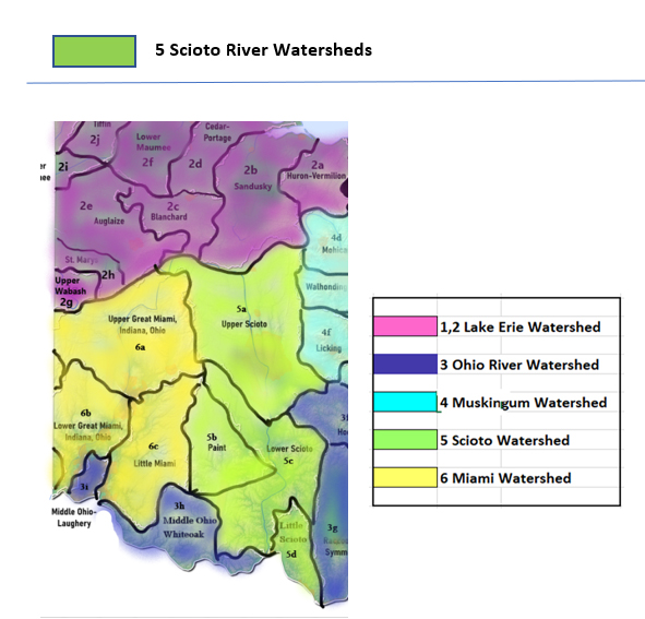
Watersheds

Scioto River With the Flow Report for the Week of June 5 to June 11, 2023
Stream flows, algae blooms, drinking water advisories and spills in the Scioto River watersheds
Find your location in the Scioto River drainage basin. Impacts to water within the watersheds of the Scioto River basin may affect drinking water supplies for residents within the same watershed. Downstream impacts can reach the Ohio River, which is a source of drinking water for many Ohio populations including East Liverpool, Portsmouth and Cincinnatti, cities and towns in Indiana and Kentucky. Downstream effects from flood or low flow will reach the Mississippi River, and large spill incidents or run-off from industry and agriculture can impact the drinking water supplies of communities through the Midwest and all the way to Louisiana and the Gulf of Mexico. Follow these events and incidents by watershed area, tracking your nearest upstream flow monitoring stations on USGS Waterwatch.
|
Drainage Basin
Scioto River
|
Low Flows
|
HABs
|
Drinking Water Advisories
|
Hazardous Spills
|
|
Upper Scioto
|
2
|
0
|
8
|
6
|
|
Paint Creek
|
2
|
0
|
4
|
0
|
|
Lower Scioto
|
1
|
0
|
2
|
1
|
|
Little Scioto - Tygarts
|
0
|
0
|
0
|
0
|
|
Totals
|
5
|
0
|
14
|
7
|
Table updated June 12, 2023
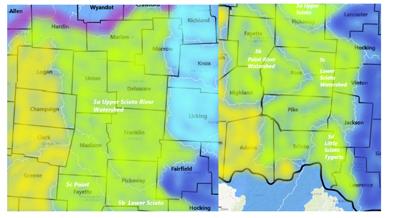
5a Upper Scioto Watershed
The Upper Scioto and tributaries gather the runoff from a vast area of central Ohio south of the drainage divide, influenced by hazardous spill incidents, industrial and municipal discharges and rainfall/snowmelt coming from parts of Madison, Union, Franklin, Pickaway, Champaign, Logan, Marion, Delaware, Morrow, Crawford, Licking, Knox, Fairfield Counties
Upper Scioto River drains an area of 980 sq miles in Marion and Delaware Counties. The flow
- at La Rue in Marion County normal flow is around 60 cfs, and 3.5 ft deep, (flood Stage 12ft)
- at Prospect in Delaware County normal flow is around 400 cfs and 3 ft deep (flood Stage 12ft), temp and conductance are measured here
- below O’Shaughnessy Dam near Dublin normal flow is around 700 cfs and 5 ft deep
- at 5th Ave Columbus in Franklin County flow is unrated, we have seen it around 950 cfs and 8.5 ft deep when the upstream flows are normal
- at Columbus is normal flow is around 1300 cfs and 7.5 ft deep, (flood stage 24 ft)
- near Commercial Point in Pickaway County the flow is unrated, commonly around 2500 cfs and 11 ft deep
Mill Creek drains an area of 178 sq miles in Delaware County. The flow at Bellepoint has been monitored for 77 years equipment malfunction
Whetsone Creek drains an area of 37.9 sq miles in Morrow County. The flow at Mt. Gilead is unrated, it is usually around 30 cfs and 2.5 ft deep when other streams in the area are normal (flood stage 9 ft)
Big Walnut Creek drains an area of in Delaware County. The flow
- at Sunbury normal flow is around 80 cfs and 5 ft deep
- at Central College normal flow is around 120 cfs, and 3.5 ft deep, (flood stage 11.7 ft)
- at Rees normal flow is around 500 cfs and 3 ft deep
Little Darby Creek drains an area of 162 sq miles in Madison County. The flow at West Jefferson is not rated, we see it around 240 cfs and 6.5 ft deep.
Big Darby Creek drains an area of 534 sq miles in Pickaway County. The streamflow gauge at Darbyville in normal flow conditions is around 650 cfs and 3.5 ft deep.
Hellbranch Run drains an area of 35.8 sq miles in Franklin County. The normal flow values at Harrisburg are around 30 cfs and 5 ft deep
Alum Creek drains an area of 189 sq miles in Delaware County. The flow
- near Kilbourne flow is unrated, around 55 cfs and 3 ft deep are common;
- at Africa normal flow is less than 300 cfs and 2.5 feet deep; temp is measured here;
- at Columbus flow is not rated, gets to 3.5 ft deep when upstream is flowing normal;
Olentangy River drains an area of 157 sq miles in Marion County, 393 sq miles by the time it reaches Delaware
- Normal flow at Claridon in Marion County is around 2.5 ft deep;
- near Delaware in Delaware County normal flow is around 150 cfs and 2.3 ft deep (flood Stage 9ft)
- near Worthington normal flow is around 250 cfs and 2.5 ft deep
- at JH Herrick Dr at Columbus flow is unrated, commonly around 260 cfs and 711.37 ft deep.
Flows (2 low) June 12 11:00 am EDT
Scioto River is flowing
- much above normal at La Rue - flow depth of 4.34 ft at 351 cubic feet per second
- below normal below O'Shaughnessy Dam near Dublin - down overnight - flow depth of 3.7 ft at 86 cubic feet per second
Olentangy River is flowing much below normal near Delaware - down overnight to a flow depth of 1.52 ft at 25 cubic feet per second
HABs (0)
Public Drinking Water Advisories (8) confirmed ongoing as of June 12, 2023
Galion City (Crawford, Morrow, Richland) Sensitive population advisory issued by Ohio EPA
Reason for advisory: Exceeds maximum contaminant level for by-products of disinfection - total trihalomethane
MCL = .08mg/L Locational running annual average of 0.083 mg/L
Warning: Some people who drink water containing trihalomethanes in excess of the MCL over many years may experience problems with their liver, kidneys, or central nervous systems, and may have an increased risk of getting cancer.
This is a community system serving 10,001 to 50,000 persons from surface water source
Greentree Mobile Home Park - Galloway (Madison)
Boil Water Advisory issued by Ohio EPA
Boil all water used for drinking, cooking and brushing teeth, a rolling boil for over one minute.
This is a community system serving less than 250 persons from groundwater source
Oak Hills Mobile Home Park, Grove City (Franklin ) Sensitive Population Advisory issued by Ohio EPA
Exceeds standards for inorganic chemical – arsenic
You do not need to use an alternative (e.g. bottled) water supply. However, if you have specific health concerns, consult your doctor.
Source - erosion of natural deposits; Runoff from orchards; Runoff from glass and electronics production wastes - MCL = 10 ug/l
The running annual average arsenic concentration for arsenic is 0.01 mg/L (11 ug/L) for the fourth quarter of 2022
This is a community system serving between 251 and 1000 persons from groundwater source
McDonalds Restaurant, London (Madison) Sensitive Population Advisory – issued by Ohio EPA
Exceeds standards for inorganic chemical – arsenic
You do not need to use an alternative (e.g. bottled) water supply. However, if you have specific health concerns, consult your doctor
This is a community system serving between 251 and 1000 persons from groundwater source
Nex Transport, East Liberty (Logan) Do Not Drink - Sensitive Populations issued by Ohio EPA
Exceeds maximum contaminant level – Lead
Pregnant and nursing women and young children should not use the water
Lead 90th percentile result = 33.6 ug/L
This is a non-transient system serving less than 250 people from groundwater source
Trillium Farms, Croton (Licking) Sensitive Population Advisory issued by the Ohio EPA
Exceeds standards for inorganic chemical - fluoride
Children under nine should be provided with alternative sources of drinking water or water that has been treated to remove fluoride in order to lessen the risk of cosmetic discoloration of their permanent teeth.
This is a non-transient system serving less than 250 people from groundwater source
Whispering Pines, Pataskala (Pickaway) Sensitive Population Advisory issued by the Ohio EPA
Exceeds standards for inorganic chemical - fluoride
Children under nine should be provided with alternative sources of drinking water or water that has been treated to remove fluoride in order to lessen the risk of cosmetic discoloration of their permanent teeth.
MCL = 4 mg/l and Secondary MCL = 2 mg/l
This is a community system serving less than 250 persons from groundwater source
Mt Victory Village (Hardin) Sensitive Population Advisory issued by the Ohio EPA
Exceeds standards for inorganic chemical - fluoride
Children under nine should be provided with alternative sources of drinking water or water that has been treated to remove fluoride in order to lessen the risk of cosmetic discoloration of their permanent teeth
MCL = 4 mg/l and Secondary MCL = 2 mg/l
This is a community system serving between 251 and 1000 persons from groundwater source
Spills (7)
- June 5 - unknown amount of human sewage reported spilled in Clinton Township – Franklin
- June 6 - unknown amount of hydraulic oil reported spilled in Columbus – Franklin
- June 6 - unknown amount of unknown material reported spilled in Columbus – Franklin
- June 7 - fish kill noted in Columbus - Franklin - Bliss Run affected *
- June 9 - unknown amount of human sewage reported spilled in Mount Gilead - Morrow - Whetstone Creek affected *
- June 9 - unknown amount of human sewage reported spilled in Columbus - Franklin - Unnamed waterbody affected *
5b Paint Creek Watershed
Flows gather up the runoff from parts of Clinton, Ross and Highland Counties
Paint Creek drains an area of 249 sq miles in Clinton and Ross Counties. The flow
- at Greenfield normal flow is around 250 cfs and 2.8 ft deep;
- near Bainbridge is not rated, 3.3 ft deep, temp is recorded here;
- near Bourneville normal flow is around 850 cfs and 3.4 ft deep (flood stage 12 ft)
- at Chillicothe normal flow is around 1000 cfs and 7 ft deep.
Rattlesnake Creek drains an area of 209 sq miles in Highland County. The flow at Centerfield is commonly 3 ft deep.
Rocky Fork Creek drains an area of 140 sq miles in Highland County. The normal flow at Barretts Mills is 150 cfs and 2.7 ft deep.
Flows (2 low) June 12 11:00 am EDT
Rocky Fork is flowing much below normal at Barretts Mills - down overnight - flow depth is 1.86 ft at 26.7 cubic feet per second
Paint Creekis flowing
- below normal at Bourneville - flow depth is 1.5 ft at 106 cubic feet per second
-
- much below normal at Chillicothe - down overnight - flow depth is 5.34 ft at 159 cubic feet per second
HABs (0)
Public Drinking Water Advisories (4)
confirmed ongoing June 12, 2023
Dollar General #20756, Mount Sterling (Madison) Boil Water Advisory issued by Ohio EPA
Microbiological contamination with e.coli
Boil the water before using or use bottled water
This is a non-community system serving less than 250 persons from groundwater source
Fayette Co – Culpepper Subdivision, Washington (Fayette) Do Not Drink - Sensitive Populations advisory issued by Ohio EPA
Exceeds standard for lead
Pregnant and nursing women and young children should not use the water
Action Level = 15 ug/l Measured level in the system 17.9 ug/L
This is a community system serving between 251 and 1000 persons from purchased surface water
Bowersville Village PWS (Greene) Sensitive Population Advisory issued by the Ohio EPA
Exceeds standards for inorganic chemical - fluoride
Children under nine should be provided with alternative sources of drinking water or water that has been treated to remove fluoride in order to lessen the risk of cosmetic discoloration of their permanent teeth.
This is a community system serving between 251 and 1000 persons from purchased surface water
South Solon Village PWS, (Madison) - Do Not Drink - Sensitive Populations advisory issued by the Ohio EPA
Exceeds standard for lead
Pregnant and nursing women and young children should not use the water
This is a community system serving between 251 and 1000 persons from groundwater source
Spills (0)
- no new spill reports found for the period June 5 to June 11, 2023
5c Lower Scioto River Watershed
Flows take in runoff from parts of Madison, Highland, Franklin, Pickaway, Ross and Pike counties
Scioto River (Lower) drains an area of 5836 sq miles from its headwaters in Marion County down to its outlet at the Ohio River
- the lower end flow at Circleville in Pickaway County is not rated, around 3000 cfs and 4 ft deep
- at Chillicothe in Ross County, flow has been monitored for 100 years, normal flow is around 4500 cfs and 5 ft deep (flood stage 16 ft)
- at Higby in Ross County normal flow is around 5400 cfs and 4.5 ft deep
- at Piketon in Pike County is not rated, 6800 cfs, and 6 ft deep is pretty standard when the upstream stations are measuring normal flows(flood stage 20 ft)
Deer Creek drains an area of 228 sq miles in Madison County. The flow
- at Mount Sterling normal flow is around 240 cfs and 5 ft deep;
- near Pancoastburg is not rated and 1.5 ft deep;
- at Williamsport the flow is not rated, 4 ft deep
Walnut Creek drains an area of 274 sq miles in Pickaway County. The flow at Ashville is unrated, around 250 cfs and 6 ft deep.
Sunday Creek drains an area of 104 sq miles in Athens County before flowing south and west, joining the Lower Scioto. The flow
- near Burr Oak is around 3ft deep
- at Glouster is around 3 ft deep (flood stage 16 ft)
Low Flows (1 low)
June 12, 2023
Scioto River is flowing
- much below normal at Chillicothe - flow depth is 2.13 ft at 779 cubic feet per second
- much below normal at Higby - down overnight - flow depth is 1.65 ft at 1130 cubic feet per second
HABs (0)
Public Drinking Water Advisories (2)
confirmed ongoing June 12, 2023
Cooks Creek Golf Club, Ashville (Pickaway) Boil Water Advisory
Microbiological contamination – confirmed presence E. coli
Boil the water before using or use bottled water
This is a non-community system serving less than 250 persons from groundwater source.
Clarksburg Village Public Water System ( Ross) Sensitive Population Advisory issued by Ohio EPA
Exceeds standards for inorganic chemical - fluoride
Children under nine should be provided with alternative sources of drinking water or water that has been treated to remove fluoride in order to lessen the risk of cosmetic discoloration of their permanent teeth.
MCL = 4 mg/l and Secondary MCL = 2 mg/l The fluoride result for a sample collected on 1/5/2022 was 2.1 mg/L.
This is a community system serving between 251 and 1000 persons from groundwater source
Spills (1)
- June 7 - unknown amount of antifreeze - motor oil and 50 gallons of diesel reported spilled in Perry Township – Pickaway
5d Little Scioto River Watershed
Tygart’s Creek drains 242 sq miles in Greenup County flowing north to the Ohio River. Normal flow near Greenup, KY is 400 cfs and 4 ft deep.
Low Flows (0)
June 12, 2023
HABs (0)
Public Drinking Water Advisories (0)
confirmed ongoing June 12, 2023
Spills (0)
- No hazardous spill reports found for the search period of June 5 to 11, 2023
Report Key
With the Flow Ohio tracks trends in your watershed, posting updates from USGS WaterWatch Current Streamflow and Ohio EPA Division of Drinking and Ground Waters, Ohio Beachguard (seasonally).
Flows:
With The Flow describes Ohio’s rivers and tributaries from headwaters to outlet. Locate your “home body” (the river or stream nearest you) to see where the flow originates, how high it has to be for minor flooding to occur. Log in to USGS Waterwatch current streamflow for real time measurements at the monitoring station nearest you and sign up there for high flow alerts.
Flow volume can change rapidly during snowmelt and rain events. Streamflow data is subject to review as sensors at the monitoring stations do malfunction from time to time. Refer to USGS Provisional Date Statement for more information.
Public Drinking Water Advisories
The Safe Drinking Water Act (SDWA) is federal law that safeguards the public drinking water supply. SDWA requires drinking water facilities (DWF) in every state follow national quality standards, monitor, record and report on water quality with quarterly inspections. EPA provides public access to the inspection reports, violations and enforcement actions on all registered DWFs in the USA. Annual water quality reports are required from every DWF, available from the facility, describing the treatment process and source water.
DWFs are categorized as follows:
- community system serves the same people year round
- Non-transient, Non-Community – supplies water to at least 25 of the same people at least six months of the year
- Transient, Non-Community – supplies water to intermittent users, temporarily at the location eg. Gas stations, campgrounds
Note from Ohio EPA: “Boil advisories that are on record with Ohio EPA often are related to exceedances of E.coli maximum contaminant levels (MCL) at public water systems, or other major events. Staff in Ohio EPA’s district offices update (public drinking water) advisories at least monthly. Many of the advisories are based on sampling results that occur monthly, quarterly, semi-annually, or less frequently, depending on the requirements of state and federal drinking water regulations.
All advisories, including those involving more immediate health risks such as boil advisories, are required to be communicated directly to consumers by the individual public water systems.
When a boil advisory is not required by rule, a public water system will issue a precautionary boil advisory and the public water system would not be required to submit it to Ohio EPA. Ohio EPA does not have a record of all (or even most) boil advisories for Ohio public water systems.” (Dina Pierce, spokesperson for Ohio EPA)
Hazardous Spills
Spills, fish kills, rainbow sheen and releases of contaminants in the state of Ohio are reported here by watershed, as per the data source, the Ohio Environmental Protection Agency, Office of Environmental Response. Users of this data should be aware that inconsistencies and inaccuracies may exist if these data are compared to data from other time periods due to changes in methods of data collection and mapping.
This report includes spills reported to the Ohio EPA as follows:
- 40 gallons or more of petroleum product
- toxic chemical materials, corrosives spills of any amount
- all reports impacting water bodies
Spills marked with asterisk are followed up with Ohio EPA authorities for additional information on the clean-up and recovery, including notices of violation and charges under State environmental statutes, federal charges under the Clean Water Act. See Ohio CrimeBox for more information on criminal prosecutions under the CWA.
--#include virtual="/includes/wtoh-disclaimer-end.inc"-->
|


