  
Watersheds

Ohio River minor tributaries With the Flow Report for the Week of June 5 to June 11, 2023
Find your location in the Ohio River minor tributaries watersheds. Impacts to water within these watersheds can impact drinking water supplies for residents within the same watershed. Downstream impacts of mobile contaminants will travel down the Ohio River, which is a source of drinking water for many Ohio populations including East Liverpool, Portsmouth, Cincinnati and Louisville, Kentucky. Further downstream effects from hazardous spills, flood or low flow can impact the Mississippi River. Large spill incidents or run-off from industry and agriculture can impact the drinking water supplies of communities through the Midwest and all the way to Louisiana and the Gulf of Mexico. Follow the events and incidents that impact your drinking water, by watershed area.
|
Drainage Basin
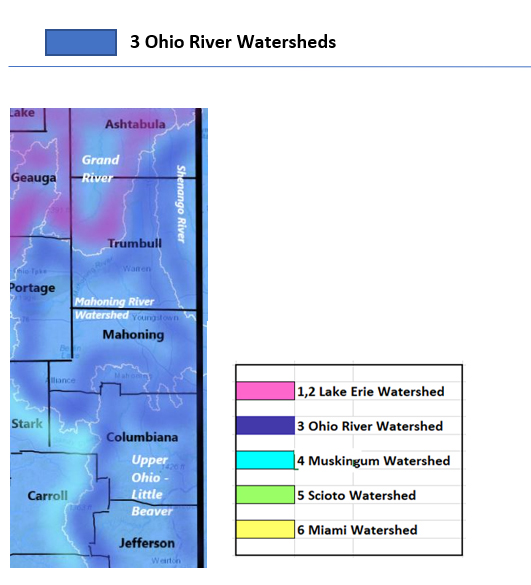
Upper Ohio Minor Tributaries
|
Low Flows
|
HABs
|
Drinking Water Advisories
|
Hazardous Spills
|
|
Shenango River
|
0
|
0
|
0
|
0
|
|
Mahoning River
|
1
|
0
|
1
|
4
|
|
Little Beaver Creek
|
2
|
0
|
0
|
0
|
|
Wheeling Creek
|
0
|
0
|
2
|
1
|
|
Shade River
|
0
|
0
|
0
|
0
|
|
Totals
|
3
|
0
|
3
|
5
|
Table updated June 12, 2023
3a Shenango River
The paddle-popular Shenango River system originates in Pennsylvania’s Shenango Valley. The river flows in and out of northeast Ohio, winding its way through west PA on its way down to meet the Ohio River. “The Shenango River Watchers is a 501(c)(3) non-profit watershed group formed to restore and protect the environmental, scenic, and recreational attributes of the Shenango River Watershed”, mission statement of the award winning group that organizes clean-up events and an annual Thanksgiving Day 5k Gobble Wobble, taking off from Hermitage, PA. The group has information resources for paddlers on their website www.shenangoriverwatchers.org.
Flows: caught from parts of Ashtabula, Trumbull, Mahoning
USGS does not have river monitors placed on the Shenango River on the Ohio side of the border, but the following systems flowing into the Shenango River are monitored:
Pymatuning Creek drains an area of 96.7 sq miles in Trumbull County to join the Shenango River across the state line in Pennsylvania. The flow at Kinsman in Trumbull County is generally around 8 ft deep, temperature and conductance are measured here
Shenango River (upper) drains an area of 584 sq miles including parts of Trumbull County in Ohio. The river flows on the PA side of the border, flow
- at Pyamatuning Dam normal flow is around 500 cfs and 5 ft deep;
- at Sharpsville normal flow is 1200 and under 4 ft deep (flood stage 6.8ft). temperature is measured here
Flows (0 low)
HABs (0)
Public Drinking Water Advisories (0)
Spills (0 new)
No hazardous spills found for the search period of June 5th – 11th 2023
3b Mahoning River
Flows: draining parts of Stark, Mahoning, Trumbull
Mahoning River drains an area of 978 sq miles in portions of Stark and Trumbull Counties as it flows west to east, exiting the state via Trumbull County and joining Shenango River before reaching the Ohio River.
- at Alliance, nearest the headwaters in Stark County the flow is not rated, commonly 4 ft deep, temperature is recorded here;
- below Berlin Dam near Berlin Centre flow is unrated, around 500 cfs and 3 ft deep (flood stage 5.4ft), temp sensor available here;
- at Pricetown in Mahoning County normal flow is around 600 cfs and 4 ft deep (flood stage 8.1ft), temp sensor here;
- at Leavittsburg normal flow is around 1000 cfs and 4.8 ft deep (flood stage 12.5), temp here also;
- below West Ave at Youngstown normal flow is 450 cfs and 3 ft deep (flood stage 14ft) temp and conductance monitors here;
- at Lowellville the flow is unrated, around 1700 cfs and 4 ft deep with temp and conductance sensors here
West Branch Mahoning River drains an area of 82 sq miles in Portage County. The flow
- near Ravenna is 2 ft deep, water temp monitor here;
- at Wayland flow is unrated, around 180 cfs and 4.5 ft deep, temp is monitored here
Crab Creek drains an area of 14 sq miles in Mahoning County before joining the Mahoning River at Youngstown. Normal flow at Youngstown is 4 ft deep (flood stage 12 ft)
Mosquito Creek drains an area of 97.5 sq miles in Trumbull County before joining the Mahoning River south of Warren City
- the headwaters, near Greene Centre, flow is unrated, around 7 cfs and 5 ft deep, temperature sensor here;
- flow below Mosquito Creek Dam near Cortland is unrated, around 90 cfs and 1.8 ft deep (flood stage 4.5 ft) temp sensor here.
Eagle Creek drains an area of 97.6 sq miles in Trumbull County, exiting the state before joining Shenango River. Normal flow at Phalanx Station in Trumbull County is around 100 cfs and 5 ft deep (flood stage 9.5 ft)
Flows (1 low) June 12 11:00 am EDT
Eagle Creek is flowing much below normal at Phalanx Station - flow depth is 4.1 ft at 14.2 cubic feet per second
HABs (0)
Public Drinking Water Advisories (1) confirmed ongoing as of June 12, 2023
Pleasant Valley Church - Niles (Trumbull) Do not drink – sensitive population advisory has been issued by Ohio EPA for the Pleasant Valley Church Public Water System in Niles, Trumbull County for lead and copper in excess of the maximum contaminant level. This is a non-transient, non-community system serving under 250 people. Note from OEPA, The action level for lead has been exceeded for the July ― December 2022 monitoring period.
Spills (4 new)
- June 6 - unknown amount of human sewage reported spilled in Hirma – Portage
- June 7 - unknown amount of diesel fuel reported spilled in Poland Township - Mahoning - 74 gallons of diesel recovered
- June 8 - unknown amount of unknown material and human sewage reported spilled in Liberty Township – Trumbull
- June 8 - unknown amount of crude oil reported spilled in Goshen Township – Mahoning
3c Upper Ohio - Little Beaver Creek
Flows: catching parts of Jefferson, Carroll, Columbiana, Harrison Counties
Little Beaver Creek drains an area of 496 sq miles of Columbiana County into the Ohio River. The normal flow at East Liverpool is around 500 cfs and 3.8 ft deep.
Yellow Creek drains an area of 147 sq miles in Jefferson County. Flow
- at Amsterdam flow is unrated, presenting around the 1.9 ft mark
- near Hammondsville, normal flow is around 200 cfs and 2.3 ft deep
Short Creek drains an area of 123 sq miles in Jefferson County. Flow
- at Dillonvale station, normal flow is around 1000 cfs, 2.5 ft deep (Flood Stage 9ft)
Flows (2 low) June 12 11:00 am EDT
Little Beaver Creek is flowing much below normal near East Liverpool - running 2.58 ft deep at 107 cubic feet per second
Yellow Creek is flowing much below normal near Hammondsville - running 1.39 ft deep at 18.8 cubic feet per second
HABs (0)
Public Drinking Water Advisories (0)
Spills (0 new)
- No hazardous spills found for the search period of June 5th – 11th 2023
3d Upper Ohio - Wheeling Creek
Flows: catching parts of Belmont, Monroe Counties
Wheeling Creek drains an area of 97sq miles in Belmont County. Flow is normal at around 135 cfs and, 1.8 ft deep (Flood stage 6ft).
Captina Creek drains an area of 127 sq miles in Belmont County. Normal flow for the station at Armstrong Mills is 120 cfs and 4.65 ft deep, flood stage is unreported at this location.
Flows (0 low)
HABs (0)
Public Drinking Water Advisories (2) confirmed June 12, 2023
Mount Pleasant (Jefferson) Do not drink – sensitive population advisory issued by Ohio EPA
Exceed maximum contaminant level for lead and copper
This is a groundwater source, community system serving 251-1000
Cardinal Operating Company 1, 2 and 3 Public Water Systems, Brilliant (Jefferson) Do not drink – sensitive population advisory (ongoing) has been issued by Ohio EPA
Exceed maximum contaminant level: lead and copper
This is a non-transient, non-community system serving under 250 people
*Lead poses the greatest risk to young children and pregnant women. The CDC recommends children and pregnant women use bottled water or water from a filtration system that has been certified by an independent testing organization to reduce or eliminate lead for cooking, drinking and baby formula preparation.
Spills (1 new)
June 9 - unknown amount of unknown material reported spilled in Flushing – Belmont
3e Upper Ohio - Shade River
Flows: parts of Meigs County
Shade River drains an area of 156 sq miles in Meigs County. The monitoring station located near Chester is unrated, we have seen it at 6 ft deep (flood stage 17ft deep). Temperature is monitored here.
Flows (0)
HABs (0)
Public Drinking Water Advisories (0)
Spills (0 new)
No hazardous spills found for the search period of June 5th – 11th 2023
|
Drainage Basin
Middle Ohio Minor Tributaries
|
Low Flows
|
HABs
|
Drinking Water Advisories
|
Hazardous Spills
|
|
Hocking River
|
0
|
0
|
3
|
0
|
|
Raccoon -Symmes
|
0
|
0
|
1
|
1
|
|
Brush – White Oak
|
1
|
0
|
0
|
2
|
|
Laughery Creek
|
0
|
0
|
0
|
0
|
|
Totals
|
1
|
0
|
4
|
3
|
Table updated June 12, 2023
3f Hocking River
Flows: contains parts of Athens, Hocking, Fairfield Counties
Hocking River drains an area of 943 sq miles in Hocking County; the station
- at Enterprise in Hocking, normal flow is 460 cfs and 2.5 ft deep (flood stage 12ft);
- at Athens, normal looks to be around the 1100 cfs mark and, 5.7 ft deep (flood stage 20ft).
Clear Creek drains an area of 89 sq miles in Hocking County, joining Hocking River; at the station near Rockbridge in Hocking County, a normal flow is around 90 cfs and 1.5 ft deep
Flows (0 low)
HABs (0)
Public Drinking Water Advisories (3)
Berne Station Public Water System, Lancaster ( Fairfield) Boil Water Advisory issued by the Ohio EPA
Exceeds standards for microbacterial contamination e.coli
MCL = confirmed presence of e.coli
This is a non-community system serving under 250 persons from a groundwater source
Nelsonville Public Water System, (Athens) Sensitive Population Advisory issued by Ohio EPA
Exceeds standards for Disinfection Byproducts – Trihalomethane - By-product of drinking water chlorination
You do not need to use an alternative (e.g. bottled) water supply. However, if you have specific health concerns, consult your doctor
MCL = .08 mg/L Locational running annual average of 0.086 mg/L for the April 1 to June 30, 2022 time period
This is a community system serving 3,301 to 10,000 persons from a groundwater source
Amanda Village Public Water System, (Fairfield) Water Conservation advisory, year-round and ongoing.
Asking residents to voluntarily conserve water and water yards and plants from 4-10 pm on Tues, Thurs, and Sat. No car washing, pool filling or power washing anything.
This is a community system serving 251 – 1000 customers from a groundwater source
Spills (0 new)
No hazardous spills found for the search period of June 5th – 11th 2023
3g Raccoon-Symmes Creek Watershed
Flows: rolling over parts of Hocking, Athens, Meigs, Vinton, Jackson, Gallia Counties
Raccoon Creek drains an area of 585 sq miles in Gallia County. Normal flow at Adamsville is 500 cfs and 5.5 ft deep (flood stage 21ft).
Symmes Creek drains 302 sq miles of Lawrence County into the Ohio River; at Aid, the flow is unrated, 250 cfs and 7 ft deep (flood stage 19ft deep).
Flows (0 low)
HABs (0)
Public Drinking Water Advisories (1)
Majestic Oaks Lodge (Hocking County) Boil Water Advisory issued by Ohio EPA
Microbiological Contamination with e.coli
E. coli are bacteria whose presence indicates that the water may be contaminated with human or animal wastes. Microbes in these wastes can cause diarrhea, cramps, nausea, headaches, or other symptoms. They may pose a special health risk for infants, young children, and people with severely compromised immune systems.
This is a groundwater source for a non-community system serving less than 250 persons.
Spills (1 new)
June 5 - 100 gallons of diesel and unknown amount of paint reported spilled in Elizabeth Township - Lawrence - 100 gallons of diesel recovered
3h Brush-White Oak Creek
Flows: we are talking about rainfall and snowmelt off part of Brown County
White Oak Creek drains an area of 208 sq miles in Brown County; the flow above Georgetown is unrated, we have seen it at 67 cfs and 4.3 ft deep.
Brush Creek drains an area of 387 sq miles in Adams County. Normal flow at West Union is around 330 cfs and 3.2 ft deep.
Flows (1 low) June 12 11:00 am EDT
Ohio Brush Creek is flowing much below normal near West Union - flow depth is 1.94 ft at 8.17 cubic feet per second
HABs (0)
Public Drinking Water Advisories (0)
Spills (2 new)
June 7 - unknown amount of trade name mixture reported spilled in Clay Township – Highland
June 10 - unknown amount of sewage sludge reported spilled in Pierce Township - Clermont - Ninemile Creek affected *
3i Laughery Creek
Flows: rainfall and snowmelt from central Butler and Hamilton Counties
Middle Ohio- Laughery Creek drainage area occupies just over 900 000 acres in Ohio, Kentucky and Indiana. The flow monitoring stations in Ohio are found on Mill Creek.
Mill Creek drains an area of 115 square miles in Butler and Hamilton Counties. The flow
- at Evendale is unrated, it can be 50 cfs and, 5 ft deep (flood stage 12ft)
- at Kemper Road at Sharonville can be 3.6 ft deep;
- at East Sharon Rd in Sharonville the flow is unrated, we have recorded it at 222 cfs, and 6.6 ft deep;
- at Reading flow is not ranked, we have it at 5 ft deep in average conditions;
- at Carthage the flow is unrated, it has been known to flow at 73 cfs and 5.8 ft deep
West Fork Mill Creek drains an area of 29.9 sq miles in Hamilton County. The Reservoir near Greenhills is commonly around 675 ft deep.
Sharon Creek drains an area of 5.39 sq miles miles in Hamilton County. The flow at Sharonville can be around 1.7 ft deep in average conditions.
Congress Run drains an area of 3.88 sq miles in Hamilton County. The flow near Carthage is unrated and can get to 3.5 ft deep when conditions are average.
Flows (0 low)
HABs (0)
Public Drinking Water Advisories (0)
Spills (0 new)
No hazardous spills found for the search period of June 5th – 11th 2023
Report Key
With the Flow Ohio tracks trends in your watershed, posting updates from USGS WaterWatch Current Streamflow and Ohio EPA Division of Drinking and Ground Waters, Ohio Beachguard (seasonally).
Flows:
With The Flow describes Ohio’s rivers and tributaries from headwaters to outlet. Locate your “home body” (the river or stream nearest you) to see where the flow originates, how high it has to be for minor flooding to occur. Log in to USGS Waterwatch current streamflow for real time measurements at the monitoring station nearest you and sign up there for high flow alerts.
Flow volume can change rapidly during snowmelt and rain events. Streamflow data is subject to review as sensors at the monitoring stations do malfunction from time to time. Refer to USGS Provisional Date Statement for more information.
Public Drinking Water Advisories
The Safe Drinking Water Act (SDWA) is federal law that safeguards the public drinking water supply. SDWA requires drinking water facilities (DWF) in every state follow national quality standards, monitor, record and report on water quality with quarterly inspections. EPA provides public access to the inspection reports, violations and enforcement actions on all registered DWFs in the USA. Annual water quality reports are required from every DWF, available from the facility, describing the treatment process and source water.
DWFs are categorized as follows:
- community system serves the same people year round
- Non-transient, Non-Community – supplies water to at least 25 of the same people at least six months of the year
- Transient, Non-Community – supplies water to intermittent users, temporarily at the location eg. Gas stations, campgrounds
Note from Ohio EPA: “Boil advisories that are on record with Ohio EPA often are related to exceedances of E.coli maximum contaminant levels (MCL) at public water systems, or other major events. Staff in Ohio EPA’s district offices update (public drinking water) advisories at least monthly. Many of the advisories are based on sampling results that occur monthly, quarterly, semi-annually, or less frequently, depending on the requirements of state and federal drinking water regulations.
All advisories, including those involving more immediate health risks such as boil advisories, are required to be communicated directly to consumers by the individual public water systems.
When a boil advisory is not required by rule, a public water system will issue a precautionary boil advisory and the public water system would not be required to submit it to Ohio EPA. Ohio EPA does not have a record of all (or even most) boil advisories for Ohio public water systems.” (Dina Pierce, spokesperson for Ohio EPA)
Hazardous Spills
Spills, fish kills, rainbow sheen and releases of contaminants in the state of Ohio are reported here by watershed, as per the data source, the Ohio Environmental Protection Agency, Office of Environmental Response. Users of this data should be aware that inconsistencies and inaccuracies may exist if these data are compared to data from other time periods due to changes in methods of data collection and mapping.
This report includes spills reported to the Ohio EPA as follows:
- 40 gallons or more of petroleum product
- toxic chemical materials, corrosives spills of any amount
- all reports impacting water bodies
Spills marked with asterisk are followed up with Ohio EPA authorities for additional information on the clean-up and recovery, including notices of violation and charges under State environmental statutes, federal charges under the Clean Water Act. See Ohio CrimeBox for more information on criminal prosecutions under the CWA.
--#include virtual="/includes/wtoh-disclaimer-end.inc"-->
|
|
