2021/11/6 Watersheds
With the Flow Ohio – Watershed Report for the Week of Nov 1-7
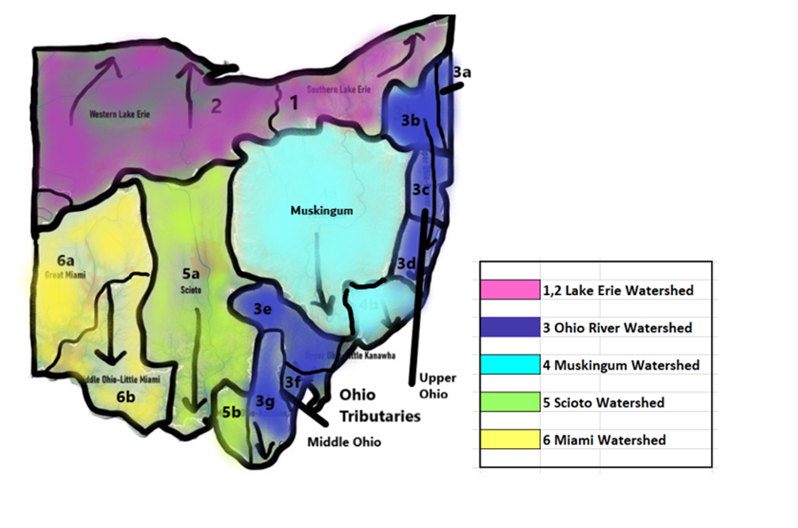
With the Flow Ohio tracks trends in your watershed, posting weekly updates from a variety of data sources, including USGS WaterWatch Current Streamflow.
Current Streamflow – data is captured from real time monitoring stations around the state, including the percentage of normal (mean) flow, flow volume in cubic feet per second, and flow depth (gage height). A river or stream that has reached action stage (heading toward flood stage) will be in boldface.
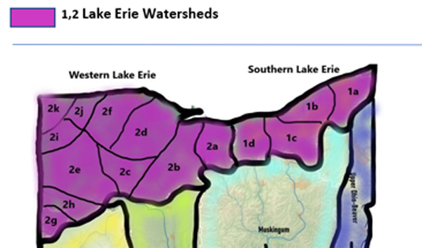
1a Grand River Watershed
Counties: Ashtabula, Lake, Geauga, Portage, Trumbull
- Conneaut Creek drains an area of 175 sq miles, at Conneaut station, the flow is rated “above normal” as of Nov 3 at 8pm EDT; 141% above mean flow rate at 357 cfs. Depth of flow is 2.65 ft, just slightly below the level from one year ago this week. The water temperature gauge is not registering as of this report.
- Grand River near Paynesville is flowing “above normal”, 188% above mean at 1650 cfs and a gage height of 4.05 ft, which is about 6” higher than last year on this date. Minor flood stage at this station is 12.5 ft. The water temperature is 9.2°C
1b Ashtabula River Chagrin River
Counties: Lake, Cuyahoga, Geauga, Portage
- Chagrin River drains an area of 246 sq miles into Lake Erie. Flow is above normal at Willoughby station, 133% above mean and discharging 329 cfs. The gage height is registering at 3.77 ft, slightly lower than this time last year.
1c Cuyahoga River
Counties: Cuyahoga, Summit, Portage, Geauga
- Cuyahoga River drains an area of 707 sq miles into Lake Erie. The flow is rated “much above normal” at Old Portage, 208% above mean at 585 cfs; flow is “above normal” at Independence station, 149% above mean flow at 926 cfs. The gage height is 4.19 ft, a bit lower than last year at this time, still far from the 17 ft flood stage. Water temperature is 10.2°C.
- Tinkers Creek drains 83.9 sq miles, is flowing in the normal range at Bedford, 55% above mean flow at 76.8 cfs, slightly more than 2.5 ft deep.
1d Black River/Rocky River
Counties: Lorain, Ashland, Huron, Cuyahoga
- Rocky River drains an area of 267 sq miles into Lake Erie. Flow at Berea is rated normal, 47% above mean flow, 115 cfs and 5.36 ft deep. The water is 9.2°C.
- Black River drains an area of 396 sq miles into Lake Erie. Flow at Elyria is normal this week, 46% above mean flow, 145 cfs and 1.7 ft deep. The water is 9.5°C.
2 Western Lake Erie Watersheds
2a Huron River/Vermillion River
Counties: Erie, Huron
- Vermillion River drains an area of 262 sq miles into Lake Erie just east of Sandusky Bay. Flow at the Vermillion monitoring station is rated “above normal”, 67.2% above mean flow at 143 cfs and 1.55 ft deep. The water temperature is 7.9°C.
- Huron River drains an area of 371 sq miles into Lake Erie east of Sandusky Bay. Flow at the Milan station rates “above normal”, 106% above mean flow at 237 cfs and just over 7ft deep. The water is 8.5°C.
- Old Woman Creek drains 22.1 sq miles. At Berlin Rd near Huron, the flow is considered “normal”, 15% above mean at 3.53 cfs, 2 ft deep.
2b Sandusky River
Counties: Sandusky, Seneca, Wyandot, Crawford (4 Main) also parts of Erie, Ottawa, Wood, Huron, Hancock, Hardin, Marion, and Richland
- Sandusky River drains an area of 1251 sq miles in Crawford and Wyandot Counties. The flow near Bucyrus in Crawford County is “above normal”, 99% above mean flow and 32.6 cfs, 1 ft deep; the flow is rated above normal, the flow at Upper Sandusky in Wyandot County s above normal, 143% above mean at 124 cfs and 1.76 ft deep; at Fremont, 131% above mean flow at 784 cfs and 1.94 ft deep. The water is 10.2 °C.
- Honey Creek drains an area of 149 sq miles in Seneca County into Sandusky River. The flow at Melmore in Seneca County is above normal, 60% above mean at 46.4 cfs and 2.5 ft deep.
- Tymochtee Creek drains an area of 229 sq miles. The flow at Crawford is normal, 36% above mean at 38.3 cfs and 2.24 ft deep
2c Blanchard River
Counties: Hardin, Hancock, Putnam, Seneca, Allen, Wyandot
- Blanchard River drains 346 sq miles into Lake Erie. The flow at Findlay is ranked “above normal”, 48% above mean, 77.7 cfs and 1.29 ft deep. The water is 10.6° C.
2d Cedar River-Portage River
Counties: Hancock, Wood, Seneca, Sandusky, Ottawa
- Portage River drains an area of 428 sq miles. The flow at Woodville is “much above normal”, 152% above mean, 355 cfs and 3.48 ft deep. The water is 9.4°C.
2e Auglaize River
Counties: Defiance, Fulton, Henry, Lucas, Paulding, Williams, Wood
- Auglaize River drains an area of 2318 sq miles into western part of Lake Erie. The flow at Defiance monitoring station is “above normal” 139% above mean, 1600 cfs and 7.17 ft deep.
2f Lower Maumee River
Counties: Allen, Auglaize, Defiance, Fulton, Hancock, Hardin, Henry, Lucus, Mercer, Paulding, Putnam, Van Wert, Williams, Wyandot, Wood (
Flows:
- Maumee River at Waterville drains an area of 6330 sq miles. The flow at Waterville is 404% above mean, 10900 cfs and 5.39 ft deep; near Defiance drains an area of 5545 sq miles, flowing 376% above mean, 8740 cfs and 3.77 ft deep, 9.6°C
2g Upper Wabash
Counties: Mercer, Darke
The headwaters of the Wabash River are in Ohio, however, USGS does not monitor flows on this system in the state of Ohio. Spills and weather incidents in this area will be noted as they occur, the residue flows west out of state.
2h St. Mary’s River
Counties: Allen, Auglaize, Defiance, Fulton, Hancock, Hardin, Henry, Lucus, Mercer, Paulding, Putnam, Van Wert, Williams, Wyandot, Wood (
- Mary’s River at Walcot Street at Willshire drains an area of 386 sq miles. The flow at Willshire is 66% above mean, 828 cfs and 6.82 ft deep.
- Mary’s River at Rockford drains an area of 340 sq miles. The flow at Rockford is 209% above mean, 692 cfs and 7.40 ft deep.
2i Upper Maumee River
Counties: Defiance, Fulton, Henry, Lucas, Paulding, Williams, Wood
- Maumee River at Antwerp drains an area of 2129 sq miles. The flow at Antwerp is 539% above mean, 4600 cfs and 12.52 ft deep.
2j Tiffin River
Counties: Allen, Auglaize, Defiance, Fulton, Hancock, Hardin, Henry, Lucus, Mercer, Paulding, Putnam, Van Wert, Williams, Wyandot, Wood (Hillsdale (MI), Lenawee (MI)
- Tiffin River at Stryker is 676% above mean, 1340 cfs and 11.71 ft deep; near Evansport is 264% above mean, 1830 cfs and 19.25 ft deep.
2k St. Joseph River
Counties: Williams, Defiance
- Joseph River near Newville drains an area of 610 sq miles. The flow at Newville is 671% above mean, 2130 cfs and 11.55 ft deep.
- Ottawa River near Kalida drains an area of 350 sq miles. The flow near Kalida is 30% above mean, 155 cfs and 4.85 ft deep.
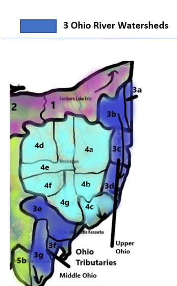
3 Ohio River Watersheds
3 Upper Ohio Tributaries
3a Shenango River
Counties: Ashtabula, Trumbull, Mahoning
- Shenango River at Pymatuning Dam drains an area of 162 sq miles. The flow at Pymatuning Dam is 441% above mean, 776 cfs and 6.24 ft deep; at Sharpsville drains an area of 584 sq miles. The flow at Sharpsville is 414% above mean, 2200 cfs and 4.98 ft deep. The water is 12°C.
3b Mahoning River
Counties: Mahoning
Mahoning River drains an area of 978 sq miles. The flow at Leavittsburg is 179% above mean, 900 cfs and 4.60 ft deep, 11.3°C; below West Ave at Youngstown 184% above mean, 1410 cfs and 2.87 ft deep. The water is 11°C.
3c Little Beaver Creek - Yellow Creek
Counties: Jefferson, Carroll, Columbiana, Harrison
Little Beaver Creek drains an area of 496 sq miles into the Ohio River. The flow at East Liverpool is normal, 85% above mean flow, 242 cfs and 3.2 ft deep.
- Yellow Creek drains an area of 147 sq miles, is flowing “normal” at Hammondsville, 100% above mean flow at 77.7cfs and 1.79 ft deep
- Short Creek drains an area of 123 sq miles, is flowing “above normal” at Dillonvale station, 126% above mean flow at 82.5 cfs.
3d Wheeling Creek
Counties: Belmont, Monroe
- Wheeling Creek drains an area of 97.7 sq miles; flow is “normal” below Blaine, 90% above mean flow at 57.6 cfs and 1.32 ft deep.
3e Hocking River
Counties: Athens, Hocking, Fairfield
- Hocking River drains an area of 943 sq miles; the station at Enterprise in Hocking County reports normal flow, 92% above mean at 171 cfs and 1 ft deep; the flow is above normal at Athens, registering 112% above mean flow, 457 cfs and 4 ft deep.
- Clear Creek drains an area of 89 sq miles, joining Hocking River; the station near Rockbridge in Hocking County reports normal flow, 74% above mean, 27.5 cfs, a little more than a foot deep
Middle Ohio
3f Shade
Counties: Meigs
- Shade River drains an area of 156 sq miles. The monitoring station located at Chester shows normal flow, 60% above mean, 33.1 cfs and 5 ft deep. The water temperature at this location is registering 7.8°C.
3g Raccoon Creek – Symmes Creek
Counties: Hocking, Athens, Meigs, Vinton, Jackson, Gallia
- Raccoon Creek drains an area of 585 sq miles. The monitoring station at Adamsville shows the river flowing above normal, 125% above mean flow at 262 cfs and 3.44 ft deep.
- Symmes Creek drains 302 sq miles of Lawrence County into the Ohio River; at Aid, the flow is 77.5% above mean at 95 cfs and 6.5 ft deep.
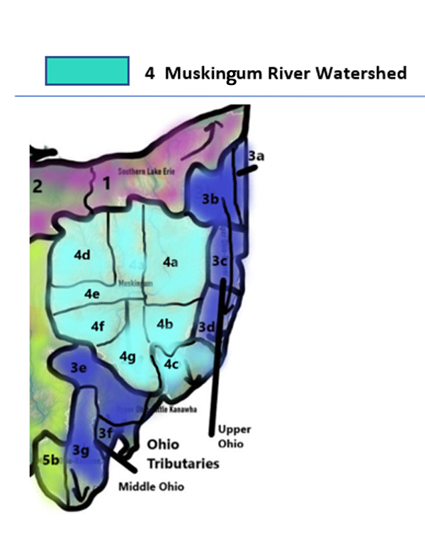
4a Tuscarawas Watershed
Counties: Tuscarawas
- Tuscarawas River drains an area of 2443 sq miles of Tuscarawas County. The flow at Newcomerstown is normal, 117% above mean at 1710 cfs and 2 ft deep
4b Wills Watershed
Counties: Licking, Guernsey, Tuscarawas
- Wills Creek drains an area of 406 sq miles in Guernsey County. The flow at Cambridge is 356% above mean at 766 cfs and 5.35 ft deep; at Derwent flow is 9.5 ft deep
4c Little Muskingum River – Middle Island
Counties: Washington, Noble, Monroe, Guernsey
- Little Muskingum River drains an area of 210 sq miles; at Bloomfield is flowing in the normal range at 42% above mean, 36.6 cfs
4d Mohican River Watershed
Counties: Richland
- Clear Fork Mohican River drains an area of 115 sq miles in Richland County. The streamflow gauge at Bellville reports flow of 2 ft deep; no volume data available
- Black Fork Mohican River drains an area of 28 sq miles in Richland County. The flow at Shelby is normal, 67% above mean at 9.4 cfs and 6 ft deep
4e Walhonding River Watershed
Counties: Knox, Morrow, Ashland, Richland, Coshocton, Holmes
- Walhonding River drains an area of 1505 sq miles in Coshocton County. The flow below Randle is 1.5 ft deep; the flow below Mohawk Dam at Nellie is 6.5 ft deep
- Kokosing River drains an area of 202 sq miles. At Mount Vernon station in Knox County, the Kokosing is flowing normal, 82% above mean flow at 82 cfs and 2.68 ft deep.
- Killbuck Creek drains an area of 464 sq miles in Holmes County. The flow at Killbuck in Holmes County is normal, 46% above mean flow at 106 cfs and 7 ft deep.
4f Licking Watershed
- Licking River drains an area of 537 sq miles of Licking County. The flow monitor at Newark is above normal, 149% above mean flow at 387 cfs and 3.84 ft deep.
- North Fork Licking River drains an area of 241 sq miles; at Utica in Licking County is flowing normal, 89% above mean at 50.5 cfs, 7.8 ft deep; at Ohio Street in Newark the flow is 3.8 feet deep. The flow is not otherwise rated at this time.
- South Fork Licking River drains an area of 133 sq miles. The station near Hebron reports above normal flows, 115% above mean flow at 104 cfs and 2.86 ft deep.
4g Muskingum Watershed
Counties: Morgan, Washington, Noble, Muskingum, Coshocton
- Muskingum River drains an area of 7947 sq miles. At Coshocton in Coshocton County the Upper Muskingum is flowing above normal, 133% at 3480 cfs and 7.46 ft deep; At Dresden in Muskingum County is flowing above normal, 137% above mean at 4520 cfs and 8.57 ft deep; At McConnelsville in Morgan County, the river is flowing above normal, 142% above mean at 5510 cfs;
- Muskingum River (lower) at Beverly station in Washington County is 78% above mean at 6040 cfs and 16.68 ft deep.
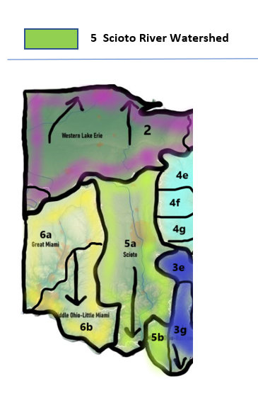
5a Upper Scioto Watershed
Counties: Madison, Union, Franklin, Pickaway, Champaign, Logan, Marion, Delaware, Morrow, Crawford, Licking, Knox, Fairfield
- The Upper Scioto River drains an area of 980 sq miles in Marion and Delaware Counties. The flow at La Rue in Marion County is normal, 50% above mean at 46 cfs, 2ft deep; the flow at Prospect in Delaware County is normal, 64% above mean at 149 cfs and 2 ft deep, water temp is 7.1C; the flow below O’Shaughnessy Dam near Dublin is normal, 88% above mean at 265 cfs, 4.21 ft deep; at Columbus in Franklin County is much above normal, 135% above mean flow at 845 cfs and 6.9 ft deep; near Commercial Point in Pickaway County the flow is 103% above mean at 1850 cfs and 10.6 ft deep
- Darby Creek drains an area of 534 sq miles in Pickaway County. The streamflow gauge at Darbyville shows above normal, flowing at 164% above mean at 303 cfs and 3 ft deep.
- Alum Creek drains an area of 122 sq miles in Delaware County. The flow at Africa is much below normal, 4% above mean at 6.3 cfs and 1.2 feet deep; 14C.
- Upper Olentangy River drains an area of 157 sq miles in Marion County, 393 sq miles by the time it reaches Delaware. The flow at Claridon in Marion County is 1.93 ft deep; the flow at Delaware in Delaware County is much above normal, 425% above mean at 898 cfs and 3.5 ft deep; near Worthington is 199% above the mean, 509 cfs and 2.83 ft deep.
- Deer Creek drains an area of 228 sq miles in Madison County. The flow at Mount Sterling is above normal, 163% above mean at 179 cfs and 4.56 ft deep/
Griggs Reservoir – Franklin County near Columbus
- Rocky Fork Creek drains an area of 140 sq miles. The flow is 172% above mean, 88.4 cfs and 2.24 ft deep.
- Big Walnut Creek drains an area of 544 sq miles. The flow at Rees in Franklin County is above normal, 98% at 317 cfs and 2.5 ft deep Central College is 80% above the mean, 101 cfs, and 3.35ft deep.
- Walnut Creek drains an area of 274 sq miles. The flow at Ashville is 71% above the mean, 81 cfs and 4.89 ft deep.
5b Lower Scioto Watershed
Counties: Pike, Ross
- Scioto River (lower) drains an area of 5836 sq miles from its headwaters in Marion County down to its outlet at the Ohio River. The lower end flow at Higby in Ross County is above normal, 174% above mean flow at 3410 cfs and 3.15 ft deep; the flow at Piketon in Pike County is 93% above mean, 4070 cfs, and 4 ft deep.
- Tygart’s Creek drains 242 sq miles. The flow near Greenup is 71% above the mean, 80 cfs and 3 ft deep.
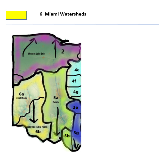
6a Upper Great Miami
Counties: Miami, Shelby, Champaign
- Great Miami River at Troy drains an area of 926 sq miles. The flow is 178% above the mean, 717 cfs and 3.07 ft deep.
Upper Little Miami
Counties: Clark, Greene
- Little Miami River at Milford drains an area of 1203 sq miles. The flow is 182% above the mean, 949 cfs, and 5.91 ft deep.
Upper Mad River
Counties: Logan, Champaign
- Mad River near Dayton drains an area of 635 sq miles. The flow is 88% above the mean, 416 cfs and 2.81 ft deep.
Honey Creek
Loramie Creek
Counties: Shelby, Darke, Mercer, Auglaize
- Loramie Creek drains an area of 257 sq miles. The flow is 138% above the mean, 86 cfs and 1.23 ft deep.
Lost Creek
Stillwater Creek
Counties: Warren
- Still Water River at Pleasant Hill drains an area of 503 sq miles. The flow is 259% above the mean, 404 cfs and 2.29 ft deep. The water is 8.7C.
Greenville Creek
Counties: Warren
- Greenville Creek near Bradford drains an area of 193 sq miles. The flow is 307% above the mean, 207 cfs and 2.20 ft deep.
6b Lower Miami Watersheds
Lower Great Miami
Counties: Hamilton, Butler
- Lower Great Miami River drains an area of 866 sq miles. The flow is 65% above the mean, 514 cfs and 1.96 ft deep.
Lower Little Miami
Counties: Hamilton, Warren, Clinton, Clermont
- Little Miami at Perintown drains an area of 476 sq miles. The flow is 76% above the mean, 159 cfs and 2.65 ft deep.
Lower Mad River
Counties: Clark, Southeast Champaign Co
- Lower Mad River at St Paris Pike drains an area of 310 sq miles. The flow is 101% above the mean, 207 cfs and 6.28 ft deep,
Beaver Creek
Counties: Greene
- Beaver Creek near Celina drains an area of 113 sq miles. The flow is 305% above the mean, 65 cfs, and 5.40 ft deep.
Paint Creek
Counties: Clinton
- Paint creek near Greenfield drains an area of 249 sq miles. The flow is 273% above the mean, 211 cfs and 2.53 ft deep.
|


