With the Flow Ohio – Watershed Report for the Week of January 9-15, 2023
Much above normal flows in Great Miami watershed
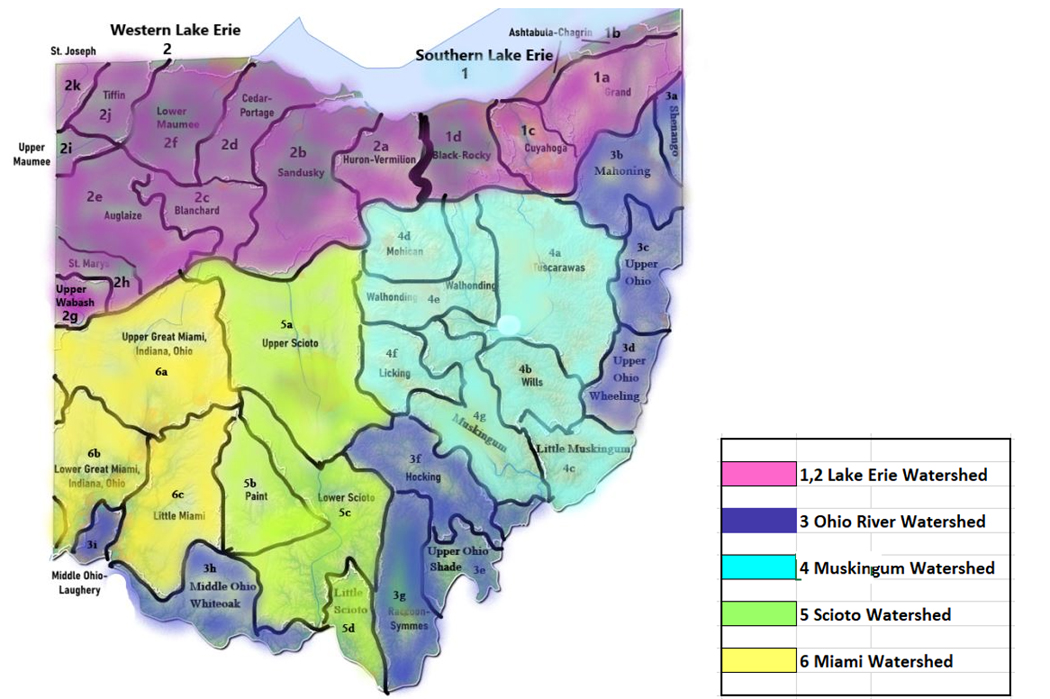
Contents
Introduction
- Southern Lake Erie Watersheds
1a Grand River Watershed
1b Ashtabula River - Chagrin River Watershed
1d Black River - Rocky River Watershed
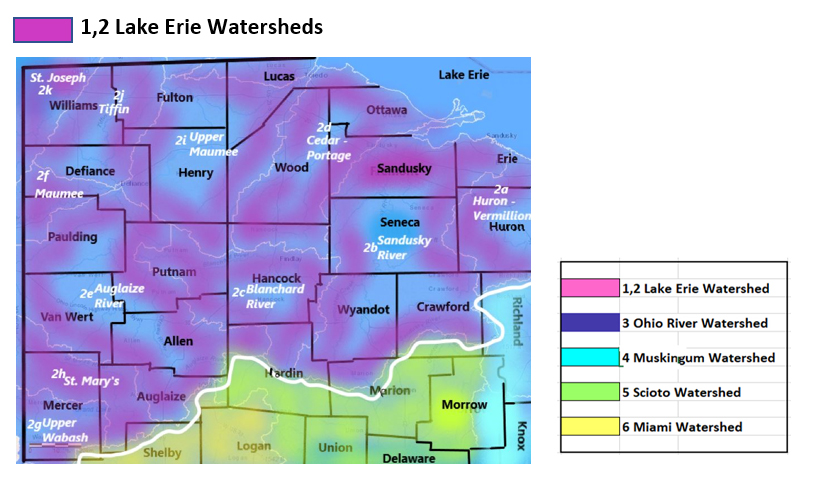
2 Western Lake Erie Watersheds
2a Huron River/Vermillion River
2b Sandusky River Watershed
2c Blanchard River Watershed
2d Cedar River-Portage River Watershed
2e Auglaize River Watershed
2f - Lower Maumee River Watershed
2g Upper Wabash River Watershed
2h St. Mary’s River Watershed
2i Upper Maumee River Watershed
2j Tiffin River
2k St. Joseph River
3 Ohio River Tributaries
3b Mahoning River
3c Little Beaver Watershed
3d Wheeling Creek Watershed
3e Shade River Watershed
3f Hocking River Watershed
3g Raccoon Creek – Symmes Creek Watershed
3h Brush - White Oak Watershed
3i Laughery Watershed
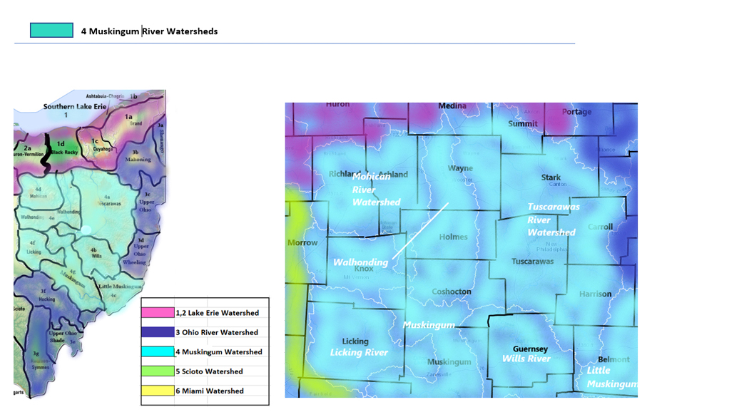
4 Muskingum River Watersheds
4a Tuscarawas River Watershed
4b Wills Creek Watershed
4c Little Muskingum River Watershed
4d Mohican River Watershed
4e Walhonding River Watershed
4f Licking River Watershed
4g Muskingum River Watershed
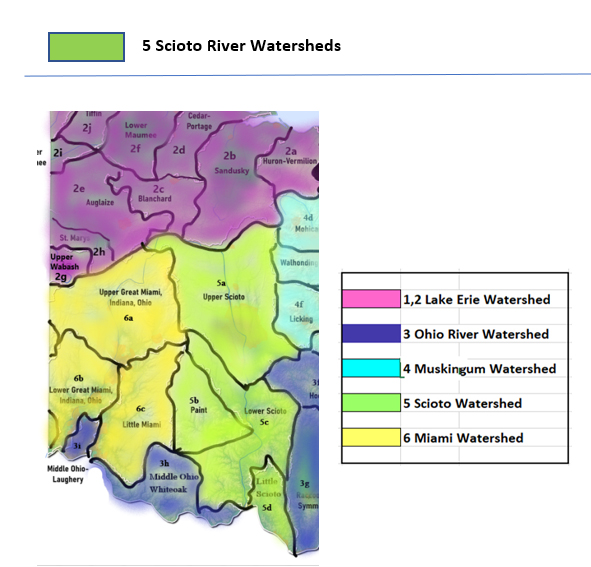
5 Scioto River Watersheds
5b Paint Creek Watershed
5c Lower Scioto Watershed
5d Little Scioto – Tygarts Watershed
6 Miami River Watersheds
6b Lower Great Miami Watersheds
6c Little Miami Watershed
Introduction
With the Flow Ohio tracks trends in your watershed, posting monthly updates from USGS WaterWatch Current Streamflow and Ohio EPA Division of Drinking and Ground Waters.
Flows:
WTOH logs a snapshot of the volume of water flowing through the state’s rivers and tributaries, as per USGS Waterwatch current streamflow monitoring stations. The report captures your watershed flows from headwaters to outlet as of the date indicated.
- Rivers, creeks flowing much above normal or high (in the top 10% of flow volume recorded for that system) are shown in boldface;
Flow volume can change rapidly during snowmelt and rain events. All readings are posted as they appear as of our monthly update. Check your local upstream station flow levels at the USGS WaterWatch Current Streamflow site and sign up for high flow alerts. Streamflow data is subject to review as sensors at the monitoring stations do malfunction from time to time.
Public Drinking Water Advisories
The Safe Drinking Water Act (SDWA) is federal law that safeguards the public drinking water supply. SDWA requires drinking water facilities (DWF) in every state follow national quality standards, monitor, record and report on water quality with quarterly inspections. EPA provides public access to the inspection reports, violations and enforcement actions on all registered DWFs in the USA. Annual water quality reports are required from every DWF, available from the facility, describing the treatment process and source water.
DWFs are categorized as follows:
- community system serves the same people year round
- Non-transient, Non-Community – supplies water to at least 25 of the same people at least six months of the year
- Transient, Non-Community – supplies water to intermittent users, temporarily at the location eg. Gas stations, campgrounds
“Boil advisories that are on record with Ohio EPA often are related to exceedances of E.coli maximum contaminant levels (MCL) at public water systems, or other major events. Staff in Ohio EPA’s district offices update (public drinking water) advisories at least monthly. Many of the advisories are based on sampling results that occur monthly, quarterly, semi-annually, or less frequently, depending on the requirements of state and federal drinking water regulations.
All advisories, including those involving more immediate health risks such as boil advisories, are required to be communicated directly to consumers by the individual public water systems.
When a boil advisory is not required by rule, a public water system will issue a precautionary boil advisory and the public water system would not be required to submit it to Ohio EPA. Ohio EPA does not have a record of all (or even most) boil advisories for Ohio public water systems.” (Dina Pierce, spokesperson for Ohio EPA)
Spills
Spills, fish kills, rainbow sheen and releases of contaminants in the state of Ohio are reported here weekly by watershed, as per the data source, the Ohio Environmental Protection Agency, Office of Environmental Response. Users of this data should be aware that inconsistencies and inaccuracies may exist if these data are compared to data from other time periods due to changes in methods of data collection and mapping.
This report includes spills of:
- 40 gallons or more of petroleum product
- toxic chemical materials, corrosives spills of any amount
- all reports impacting water bodies
Spills marked with asterisk are followed up with Ohio EPA authorities for additional information on the clean-up and recovery, including notices of violation and charges under State environmental statutes, federal charges under the Clean Water Act. See Ohio CrimeBox for more information on criminal prosecutions under the CWA.
|
Watershed Area
|
High Flows
|
Spills
|
Drinking Water Advisories
|
|
Lake Erie - South
|
0
|
n/a
|
6
|
|
Lake Erie - West
|
0
|
n/a
|
32
|
|
Ohio River Tribs
|
0
|
n/a
|
5
|
|
Muskingum River
|
0
|
n/a
|
11
|
|
Scioto River
|
3
|
n/a
|
14
|
|
Great Miami River
|
3
|
n/a
|
6
|
|
Totals
|
6
|
n/a
|
74
|
- Southern Lake Erie Watersheds
1a Grand River Watershed
Flows: capturing runoff from parts of Ashtabula, Lake, Geauga, Portage, Trumbull Counties
- Grand River drains 685 sq miles in Lake County; the flow near Painesville is normal, 43.28% above mean at 744 cfs and 3.38 ft deep (flood stage 12.5 ft) (update 01/12/23)
Public Drinking Water Advisories (1)
West Farmington Public Water System, West Farmington – Trumbull County – community system serving between 251 and 1000 persons from surface water source
Sensitive population advisory for by-products of disinfection – haloacetic acid
“Some people who drink water containing haloacetic acids in excess of the MCL over many years may have an increased risk of getting cancer.”
The maximum contaminant load MCL is .06mg/l
Locational running annual average of 0.061 mg/L at DS201 for the July 1 to September 30, 2022 time period.
Spills (0)
- No OEPA spill incident reports uploaded for 2023 as of the week of Jan 9-15, 2023
1b Ashtabula River - Chagrin River Watershed
Flows: catching parts of Ashtabula, Lake, Cuyahoga, Geauga, Portage Counties
- Conneaut Creek drains an area of 175 sq miles in Ashtabula County; at Conneaut station, the flow is normal, 38.04% above mean at 187 cfs and 2.23 ft deep; 3.4°C (updated 01/12/23)
- Chagrin River drains an area of 246 sq miles of Lake County into Lake Erie. Flow at Willoughby station, is normal at 38.10% above mean at 240 cfs and 3.64 ft deep (flood stage 12 ft) (updated 01/12/23)
- Unnamed tributary to Chagrin River drains 7.69 sq miles of Cuyahoga County. The flow
- at Pepper Pike is unrated, and 6.31 ft deep;
- at Mayfield Village is unrated, 0.69 ft deep; (updated 01/12/23)
- Euclid Creek drains an area of 5.13 sq miles in Cuyahoga County. The flow
- - at South Euclid is unrated, 0.63 ft deep;
- - at Cleveland is unrated, 19.25% above mean at 26.0 cfs and 2.34 ft deep (updated 01/12/23)
- East Branch at Euclid Creek drains 7.11 sq miles in Cuyahoga County. The flow at Richmond Heights is unrated, 1.37 ft deep , the rest of information is not available (updated 01/12/23)
Public Drinking Water Advisories (2)
Munson Elementary School in Chardon – Geauga County – non-transient system serving between 251 and 1000 persons from groundwater source
Do Not Drink advisory for sensitive populations; exceeds standards for Lead
Lead poses the greatest risk to young children and pregnant women. The CDC recommends children and pregnant women use bottled water or water from a filtration system that has been certified by an independent testing organization to reduce or eliminate lead for cooking, drinking and baby formula preparation.
The action level was exceeded based on the 90th percentile of lead sample results for June – Sept 2021. Public notice performed on 10/01/21. Updated public notice and public education received on 10/07/21. Water quality parameter results received on 11/30/21. All exceeding taps have been taken out of service or replaced and retested with results less than the action level. CCTR & source treatment recommendation submitted 3/31/22. Detail plans are overdue and still required. Source: Groundwater
Aqua Ohio – Auburn – Pepper Pike – Geauga County - community system serving between 251 and 1000 persons from groundwater source
Do Not Drink advisory for sensitive populations; exceeds standards for Lead
See above for health warning for lead
The action level was exceeded based on the 90th percentile of lead sample results for June – September 2021. Ohio EPA received both required sets of WQPs and flushed entry point L&C samples on 9/30/21. 11/1/21: Ohio EPA is currently reviewing the WQP and flushed entry point L&C sample results. The PWS provided a Corrosion Control Treatment Recommendation to OEPA on 3/24/22. The documents are currently under review. Source: Groundwater
Spills (0)
- No OEPA spill incident reports uploaded for 2023 as of the week of Jan 9-15, 2023
1c Cuyahoga River Watershed
Flows: parts of Cuyahoga, Summit, Portage, Geauga, Medina Counties
- Cuyahoga River drains an area of 788 sq miles in Ohio. With its headwaters in Geauga County, Cuyahoga takes a loop south into Portage and then hooks back north through Summit, passing through Cuyahoga County to discharge into Lake Erie.
- At Hiram Rapids, the nearest monitoring station to the headwaters in Geauga County, the flow is normal: 90.92% above mean at 255 cfs and 2.46 ft deep (flood stage 7ft);
- at Old Portage, flow is normal, 88.28% above mean at 501 cfs and 3.79 feet deep (flood at 10.5ft);
- at Jaite station is unrated, 40.25% above mean at 680 cfs and 3.60 ft deep, 7.3°C;
- at Independence station, flowing normal, 74.56% above mean at 844 cfs and 4.07 ft deep, (flood at 17 ft), 5.2°C and 750 µS/cm;
- at the Newburgh Heights station nearest the outlet in Cuyahoga County flow is unrated, 44.59% above mean at 970 cfs; 6.1° (updated 01/12/23)
- West Creek drains an area of 9.23 sq miles in Cuyahoga County. The flow
- at Pleasant Valley Rd near Parma is unrated, 10.25 ft deep (8.85 ft is minimum operating limit);
- at Ridgewood Road, Parma is unrated, flowing 4.82 ft deep (flood stage 10ft);
- at Brooklyn Heights (nearest to the outlet) is unrated, 30.17% above mean at 14.1 cfs and 14.1 ft deep. (updated 01/12/23)
- Mill Creek gathers runoff and drains 12.9 sq miles in the Cuyahoga River watershed; the flow
- at Garfield Heights is unrated, 08% above mean and 5.87 cfs and 1.57 ft deep;
- at Garfield Parkway flow is unrated, 10.67% above mean at 8.15 cfs and 0.85 ft deep (flood stage 7.5 ft) (updated 01/12/23)
- Big Creek drains an area of 35.3 sq miles in Cuyahoga County. The flow at Cleveland is unrated, 08% above mean at 224 cfs and 1.24 ft deep. (updated 01/12/23)
- East Branch Big Creek collects flow from 19.2 sq miles in Cuyahoga County. The flow at Brooklyn is unrated, 54% above mean at 8.45 cfs and 2.18ft deep. (updated 01/12/23)
- Brandywine Creek drains an area of 16.4 sq miles in Summit County. The flow near Macedonia is unrated, 6.29% above mean at 6.75 cfs and 3.11 ft deep, (flood stage is 13 ft). (updated 01/12/23)
- Indian Creek drains an area of 4.49 sq miles in Cuyahoga County. The flow at Macedonia is unrated, 8.01% above mean at 2.45 cfs and 1.95 ft deep (flood stage 9.5ft) (updated 01/12/23)
- Tinkers Creek drains an area of 83.9 sq miles of Cuyahoga County, flow at Bedford is normal, 48.24% above mean at 92.1 cfs and 2.62 ft deep (flood at 9.5 ft). (updated 01/12/23)
- Chippewa Creek drains an area of 17.5 sq miles Cuyahoga County before joining the Cuyahoga River. The flow near Brecksville is unrated, 2.69 ft deep (updated 01/12/23)
- Doan Brook drains an area of 8.2 sq miles in Cuyahoga County. The flow at MLK Jr. Dr Cleveland is unrated, 7.96 cfs and 1.97 ft deep. (updated 01/12/23)
Public Drinking Water Advisories (3)
Twinsburg – Summit County – Good Vibrations Public Water Supply - non-transient system serving <250 persons from groundwater source
Sensitive Population Advisory for Volatile Organic Compounds - 1,2-Dichloroethane
You do not need to use an alternative (e.g. bottled) water supply. However, if you have specific health concerns, consult your doctor.
Some people who drink water containing 1,2-dichloroethane in excess of the MCL over many years may have an increased risk of getting cancer.
MCL - 5µg/L Running annual average for the July 1 to September 30, 2022 time period was 55 ug/L for this contaminant. Source of contamination is listed as “discharge from industrial chemical factories”
Newbury Kinsman LLC – Newbury – Geauga County – non-transient system serving <250 persons from groundwater source
Do Not Drink – Sensitive Population Advisory for Lead
Lead poses the greatest risk to young children and pregnant women. The CDC recommends children and pregnant women use bottled water or water from a filtration system that has been certified by an independent testing organization to reduce or eliminate lead for cooking, drinking and baby formula preparation.
The action level was exceeded based on the 90th percentile of lead sample results for June – Sept 2021. Public notice and public education performed on 10/12/21. Water quality parameter results received 12/07/21. The exceeding tap was located and has been taken out of service. Failure to submit CCTR and Source Water Treatment Recommendation NOV issued on 4/1/22. Public notice is overdue (5/1/22). CCTR, source treatment recommendation & detail plans are due to OEPA by 5/31/22.
Field High School – Mogadore – Portage County- non-transient system serving between 251 and 1000 persons from groundwater source
Do Not Drink – Sensitive Population Advisory for Lead
PWS has submitted Corrosion Control Treatment Plans and they are under review pending payment
Spills (0)
- No OEPA spill incident reports uploaded for 2023 as of the week of Jan 9-15, 2023
1d Black River - Rocky River Watershed
Flows: runs off parts of Lorain, Ashland, Huron, Cuyahoga, Medina Counties
- Black River drains an area of 396 sq miles of Lorain County into Lake Erie. Flow at Elyria is normal, 22.68% above mean flow, 115 cfs and 1.57 ft deep. (flood stage 9.5 ft) 3.8°C. Specific conductance 573µS/cm. (updated 01/12/23)
- Rocky River drains an area of 267 sq miles of Cuyahoga County into Lake Erie. Flow at Berea is normal, 33.12% above mean at 150 cfs and 5.47 ft deep, (flood stage 14 ft), 4.8 ºC. (updated 01/12/23)
- East Branch Rocky River drains an area of 60.3 sq miles in Cuyahoga County. The flow near Strongsville is unrated, 4.97% above the mean, 38.6 cfs and 5.91 ft deep. (update 01/12/23)
- Plum Creek drains 15.7 sq miles in Cuyahoga County. The flow near Olmstead Falls is unrated, 10.89% above mean, 9.13 cfs and 1.83 ft deep (flood at 8ft). (updated 01/12/23)
- Abram Creek drains an area of 8.12 sq miles in Cuyahoga County. The flow
- at Kolthoff Dr./Brook Park is unrated, 0.72 ft deep;
- at Brook Park is not rated, 0.72 ft deep (min operating limit .19ft) (updated 01/12/23)
- Baldwin Creek drains an area of 8.9 sq miles in Cuyahoga County. The flow at Strongsville is unrated,2.95 ft deep. (updated 01/12/23)
Public Drinking Water Advisories (0)
Spills (0)
- No OEPA spill incident reports uploaded for 2023 as of the week of Jan 9-15, 2023
2 Western Lake Erie Watersheds
2a Huron River/Vermillion River
Flows: parts of Erie, Huron, Lorain Counties
- Vermillion River drains an area of 262 sq miles of Lorain County into Lake Erie just east of Sandusky Bay. Flow at the Vermillion monitoring station is below normal, 36.28% above mean, at 48.8 cfs and 2.35 ft deep (flood stage 9ft); (updated 01/12/23)
- Huron River drains an area of 371 sq miles of Huron County into Lake Erie east of Sandusky Bay. Flow at the Milan station is normal, 54.20% above mean at 81.3 cfs and 6.45 ft deep, (flood stage is 18 ft). 3 °C, 701 µS/cm (updated 01/12/23 )
- Old Woman Creek drains 22.1 sq miles in Erie County. At Berlin Rd near Huron, is normal, 6.33% above mean, 4.18 cfs and 2.06 ft deep (updated 01/12/23)
Public Drinking Water Advisories (0)
Spills (0)
- No OEPA spill incident reports uploaded for 2023 as of the week of Jan 9-15, 2023
2b Sandusky River Watershed
Flows: parts of Sandusky, Seneca, Wyandot, Crawford (4 Main) also parts of Erie, Ottawa, Wood, Huron, Hancock, Hardin, Marion, and Richland counties
- Sandusky River drains an area of 1251 sq miles in Crawford and Wyandot Counties. The flow
- near Bucyrus in Crawford County is normal, 43.43% above mean at 71.2 cfs and 1.43 ft deep (floods at 8.5 ft);
- near Upper Sandusky normal flow, 26.08% above mean at 121 cfs and 1.73 ft deep (flood at 13 ft);
- at Fremont, normal, 17.11% above mean at 270 cfs and 1.40 ft deep (floods at 10ft); (01/12/23)
- Honey Creek drains an area of 149 sq miles of Seneca County into Sandusky River. The flow at Melmore in Seneca County is below normal, 3.83% above mean, 11.1 cfs and 2.22 ft deep. (01/12/23)
- Rock Creek drains an area of 34.6 sq miles in Seneca County into Sandusky River. The flow
- at Republic is unrated, 1.26% above mean at 1.16 cfs and 4.15 ft deep;
- at Tiffin is much below normal, 0.42% above mean at 0.37 cfs and 3.70 ft deep (updated 01/12/23)
- Tymochtee Creek drains an area of 229 sq miles in Wyandot County into Sandusky River. The flow at Crawford is below normal, 2.80% above mean at 7.68 cfs and 2.20 ft deep (flood stage 8.5 ft). (updated 01/12/23)
Public Drinking Water Advisories (2)
Tiffin Loader Crane Company – Tiffin – Seneca County - non-transient system less than 250 persons from groundwater source
Monitoring/Reporting advisory - Public water system has provided insufficient monitoring or reporting information.
Contaminant of concern: inorganic chemicals (IOC’s): nitrite
West Lodi Outpost LLC – Bellevue – Seneca County – non-community less than 250 persons from groundwater source
Do not drink – sensitive populations – contaminant of concern inorganic chemicals - nitrite
Do not give the water to infants under 6 months old or use it to make infant formula or juice
The most recent result for this system was 24.2 mg/L for nitrate. The MCL for this contaminant is 10 mg/L.
Spills (0)
- No OEPA spill incident reports uploaded for 2023 as of the week of Jan 9-15, 2023
2c Blanchard River Watershed
Flows: drains parts of Hardin, Hancock, Putnam, Seneca, Allen, Wyandot Counties
- Blanchard River drains 756 sq miles of Hancock and Putnam Counties into Auglaize River and on to Lake Erie. The flow measured
- nearest the headwaters below Mt. Blanchard is unrated, 89.83% above mean at 84.6 cfs and 4.13 ft deep (flood at 14 ft);
- above Findlay is 111.76% above mean at 189 cfs and 6.59 ft deep;
- near Findlay is normal, 77.55% above the mean, 353 cfs and 2.18 ft deep.
- at Gilboa in Putnam County is unrated, 129.75% above mean at 606 cfs and 6.33 ft deep;
- at Ottawa in Putnam County is unrated, 101.19% above mean at 609 cfs and 9.58 ft deep;
- near Dupont is unrated, at 8.75 ft deep (updated 01/05/23)
- Lye Creek drains an area of 18.8 sq miles. The flow above Findlay is unrated, 72.01% above mean at 8.31 cfs and 1.53 ft deep (flood stage is 6ft). (01/05/23)
- Eagle Creek drains an area of 51 sq miles in Hancock County. Flow above Findlay is unrated, 33.10% above mean at 9.04 cfs and 3.21 ft deep (flood stage is 9ft) 7.2°C and 757µ/cm (updated 01/05/23)
- Riley Creek drains an area of 70.3 sq miles in Putnam County. The flow below Pandora is 70.09% above the mean, 34.7 cfs and 3.78 ft deep. (updated 01/05/23)
Public Drinking Water Advisories (2)
McComb Village – McComb – Hancock County – Community system serving 1001 – 3300 persons – surface water source
Sensitive population advisory – disinfection byproducts – haloacetic acids
You do not need to use an alternative (e.g. bottled) water supply. However, if you have specific health concerns, consult your doctor.
Dollar General Store – Dunkirk – Hardin County – non-community system – less than 250 persons – groundwater source
Boil Water Advisory – microbiological contamination - e.coli - Boil the water before using or use bottled water
Spills (0)
- No OEPA spill incident reports uploaded for 2023 as of the week of Jan 9-15, 2023
2d Cedar River-Portage River Watershed
Flows: catches parts of Hancock, Wood, Seneca, Sandusky, Ottawa Counties
- Portage River drains an area of 494 sq miles of at Sandusky County. The flow
- at Woodville is normal, 14.03% above mean, 63.7 cfs and 2.25 ft deep (flood stage 9ft) 4.3°C;
- near Elmore the flow is unrated, 6.46% above mean at 75.2 cfs and 2.20 ft deep (flood stage 12 ft) (updated 01/12/23)
Public Drinking Water Advisories (0)
Spills (0)
- No OEPA spill incident reports uploaded for 2023 as of the week of Jan 9-15, 2023
2e Auglaize River Watershed
Flows: washes parts of Defiance, Fulton, Henry, Lucas, Paulding, Williams, Wood and Allen Counties
- Auglaize River drains an area of 2318 sq miles into Maumee River, where it empties into the western part of Lake Erie. The flow station
- closest to headwaters is at Kossuth in Allen County. Flow here is unrated, 3.92%, 39.9 cfs and 4.91 ft deep;
- near Fort Jennings station is below normal, 8.11% above mean at 33.7 cfs and 1.98 ft deep (flood stage 13 ft);
- near Dupont is unrated, 12.48 ft deep;
- near Defiance is normal, 31.57% above mean, 773 cfs and 6.55 ft deep (flood stage 21 ft) (updated 01/12/23)
- Little Flat Rock Creek drains an area of 15.2 sq miles in Paulding County into Auglaize River. The flow near Junction is unrated, 09% above mean, 1.46 cfs and, 2.33 ft deep. (updated 01/12/23)
- Little Auglaize River drains an area of 401 sq miles in Paulding County into Auglaize River. The flow at Melrose is unrated, 2.23% above mean at 39.1 cfs and 12.44 ft deep. (updated 01/12/23)
Public Drinking Water Advisories (5)
Van Wert City – Van Wert – Van Wert County – Community system serving 10,001 up to 50,000 persons – surface water source
Sensitive Populations Advisory - Disinfection Byproducts (DBPs) - Trihalomethanes, total
You do not need to use an alternative (e.g. bottled) water supply. However, if you have specific health concerns, consult your doctor.
Locational running annual average of 0.083 mg/L at DS201 and 0.081 mg/L at DS202 during the July 1 to September 30, 2022 time period. MCL = .08 mg/L
Some people who drink water containing trihalomethanes in excess of the MCL over many years may experience problems with their liver, kidneys, or central nervous systems, and may have an increased risk of getting cancer.
Continental Village – Continental – Putnam County – Community system serving 1001 to 3, 300 persons – groundwater source
Do Not Drink - Sensitive Populations – for inorganic chemicals contaminant – fluoride
Children under nine should be provided with alternative sources of drinking water or water that has been treated to remove fluoride in order to lessen the risk of cosmetic discoloration of their permanent teeth. MCL = 4 mg/l and Secondary MCL = 2 mg/l
Major source: Erosion of natural deposits; Water additive; Discharge from fertilizer and aluminum factories
Grover Hill Elementary School – Paulding – Paulding County – Non-Transient system serving between 251 and 1000 persons – groundwater source
Do not Drink – sensitive population – inorganic chemicals - fluoride
Children under nine should be provided with alternative sources of drinking water or water that has been treated to remove fluoride in order to lessen the risk of cosmetic discoloration of their permanent teeth. MCL = 4 mg/l and Secondary MCL = 2 mg/l
Major source: Erosion of natural deposits; Water additive; Discharge from fertilizer and aluminum factories
Oakwood Village – Oakwood – Paulding County – Community system serving between 251 and 1000 persons – groundwater source
Do Not Drink - Sensitive Populations – for inorganic chemicals contaminant – fluoride
Children under nine should be provided with alternative sources of drinking water or water that has been treated to remove fluoride in order to lessen the risk of cosmetic discoloration of their permanent teeth. MCL = 4 mg/l and Secondary MCL = 2 mg/l
The result of the 2019 fluoride sample was 2.07 mg/L. Verification of public notice was received on February 2, 2021.
Major source: Erosion of natural deposits; Water additive; Discharge from fertilizer and aluminum factories
Waynesfield Village – Waynesfield – Auglaize County - Community system serving between 251 and 1000 persons – groundwater source
Do Not Drink - Sensitive Populations – for inorganic chemicals contaminant – fluoride
Children under nine should be provided with alternative sources of drinking water or water that has been treated to remove fluoride in order to lessen the risk of cosmetic discoloration of their permanent teeth. MCL = 4 mg/l and Secondary MCL = 2 mg/l
Major source: Erosion of natural deposits; Water additive; Discharge from fertilizer and aluminum factories
Spills (0)
- No OEPA spill incident reports uploaded for 2023 as of the week of Jan 9-15, 2023
2f - Lower Maumee River Watershed
Flows: streams from parts of Defiance, Fulton, Henry, Lucas, Paulding, Williams, Wood Counties
- Maumee River drains an area of 6330 sq miles of Ohio State. The lower portion flow at Waterville flow is normal, 35.88% above mean, 2310 cfs and, 3.01 ft deep; 4.7 C and 717 µ/cm. (flood stage 11 ft) (updated 01/12/23)
- Ottawa River drains an area of 350 sq miles in Lucas County directly into western Lake Erie. The flow
- near Lima is unrated, 8.65% above mean, 25.5 cfs and, 11.32 ft deep;
- near Kalida is unrated and equipment malfunction
- University of Toledo at Toledo, flow is below normal, 12.49% above mean, 17.1 cfs and 2.61 ft deep (flood stage 14.5 ft) (update 01/12/23)
- Wolf Creek drains an area of 24.8 sq miles in Lucas County. The flow at Holland is unrated, 122.89% above mean at 45.2 cfs and 2.65 ft deep (flood stage 13 ft). (updated 01/12/23)
- West Creek drains an area of 15.5 sq miles of Henry County before joining the Maumee River. Flow near Hamler is 0.53% above mean at 0.53 cfs and 2.75 ft deep. (updated 01/12/23)
- South Turkeyfoot Creek drains an area of 116 sq miles of Henry County before joining the Maumee River. Flow at Shunk is unrated, 5.89% above mean at 25.9 cfs and 1.49 ft deep. (updated 01/12/23)
Public Drinking Water Advisories (12)
Jan 7 – Toledo - A boil advisory is in effect as of Saturday at noon for a part of Toledo, according to the City of Toledo news release. According to the City, the Boil Advisory is in effect for the area bounded by the following: The north side of South Avenue from 1-475 to Holland Sylvania Road, The west side of Holland Sylvania Road from South Avenue to Hill Avenue, McTigue Drive from Hill Avenue to Nebraska Avenue, Nebraska Avenue from McTigue Drive to I-475, I-475 from Nebraska Avenue to South Avenue, The advisory is set to expire on Monday at 5 p.m., according to the City of Toledo news release."
Delta Village – Delta – Fulton County - Community system serving between 3,301 and 10,000 persons with surface water
Sensitive Population Advisory – Exceeds standards for Disinfection Byproducts – Trihelomethane - By-product of drinking water chlorination
You do not need to use an alternative (e.g. bottled) water supply. However, if you have specific health concerns, consult your doctor.
Northeast Water System – Wauseon – Fulton County - Community system serving between 1,001 and 3,300 persons with purchased surface water
Sensitive Population Advisory – Exceeds standards for Disinfection Byproducts – Trihelomethane - By-product of drinking water chlorination
You do not need to use an alternative (e.g. bottled) water supply. However, if you have specific health concerns, consult your doctor.
Locational running annual average of 0.087 mg/L at DS201 for the July 1 to September 30, 2022 time period. MCL = .08 mg/L
Wauseon City – Wauseon – Fulton County - Community system serving between 3,301 and 10,000 persons with surface water
Sensitive Population Advisory – Exceeds standards for Disinfection Byproducts – Trihelomethane - By-product of drinking water chlorination
You do not need to use an alternative (e.g. bottled) water supply. However, if you have specific health concerns, consult your doctor.
Locational running annual average of 0.083 mg/L at DS202 for the July 1 to September 30, 2022 time period. MCL = .08 mg/L
Northwestern Water and Sewer -Toledo Service Area – Perrysburg – Wood County – Community system serving 10,001 to 50,000 with purchased surface water
Sensitive Population Advisory – Exceeds standards for Disinfection Byproducts – Trihelomethane - By-product of drinking water chlorination
You do not need to use an alternative (e.g. bottled) water supply. However, if you have specific health concerns, consult your doctor.
Locational running annual average of 0.081 mg/L for the July 1 to September 30, 2022 time period MCL = .08 mg/L
Leipsic Village – Leipsic – Putnam County – Community system serving between 1001 and 3,300 persons with groundwater
Do Not Drink - Sensitive Populations – for inorganic chemicals contaminant – fluoride
Children under nine should be provided with alternative sources of drinking water or water that has been treated to remove fluoride in order to lessen the risk of cosmetic discoloration of their permanent teeth. MCL = 4 mg/l and Secondary MCL = 2 mg/l
The 2019 fluoride result was 2.68 mg/L. The annual Public Notice was delivered in the Consumer Confidence Report in March 2021. MCL = 4 mg/L Secondary MCL = 2 mg/L
Whispering Winds MHC – Grand Rapids – Lucas County - Community system serving less than 250 persons from a groundwater source
Do Not Drink - Sensitive Populations – for inorganic chemicals contaminant – fluoride
Children under nine should be provided with alternative sources of drinking water or water that has been treated to remove fluoride in order to lessen the risk of cosmetic discoloration of their permanent teeth. MCL = 4 mg/l and Secondary MCL = 2 mg/l
LHS Maumee Youth Center - Liberty Center – Henry County - Community system serving less than 250 persons from a groundwater source
Do Not Drink - Sensitive Populations – for inorganic chemicals contaminant – fluoride
Children under nine should be provided with alternative sources of drinking water or water that has been treated to remove fluoride in order to lessen the risk of cosmetic discoloration of their permanent teeth. MCL = 4 mg/l and Secondary MCL = 2 mg/l
The annual average fluoride concentration in 2020 was 3.06 mg/L.
Holgate Village - Holgate – Henry County – community system serving between 1001 and 3,300 from a groundwater source
Sensitive Population Advisory – Exceeds standards for Disinfection Byproducts – Trihelomethane - By-product of drinking water chlorination
You do not need to use an alternative (e.g. bottled) water supply. However, if you have specific health concerns, consult your doctor.
Locational running annual average of 0.101 mg/L at DS201 and 0.106 mg/L at DS202 during the July 1 to September 30, 2022 time period.
Do Not Drink - Sensitive Populations – for inorganic chemicals contaminant – fluoride
Children under nine should be provided with alternative sources of drinking water or water that has been treated to remove fluoride in order to lessen the risk of cosmetic discoloration of their permanent teeth. MCL = 4 mg/l and Secondary MCL = 2 mg/l
McGuffey Village – McGuffey – Hardin County – community system serving between 251 and 1000 persons from a groundwater source
Do Not Drink - Sensitive Populations – for inorganic chemicals contaminant – fluoride
Children under nine should be provided with alternative sources of drinking water or water that has been treated to remove fluoride in order to lessen the risk of cosmetic discoloration of their permanent teeth. MCL = 4 mg/l and Secondary MCL = 2 mg/l
Spills (0)
- No OEPA spill incident reports uploaded for 2023 as of the week of Jan 9-15, 2023
2g Upper Wabash River Watershed
Flows: from parts of Mercer, Darke Counties
The headwaters of the Wabash River are in Ohio, however, USGS does not monitor flows on this system in the state of Ohio. Spills and weather incidents in this area will be noted as they occur, the residue flows west out of state.
Public Drinking Water Advisories (0)
Spills (0)
- No OEPA spill incident reports uploaded for 2023 as of the week of Jan 9-15, 2023
2h St. Mary’s River Watershed
Flows from Mercer, Van Wert, Auglaize
- Mary’s River drains an area of 386 sq miles in Mercer and Van Wert Counties. From the headwaters in Mercer County, St. Mary’s flows west into Indiana into the Maumee River, which crosses back into Ohio and empties into Lake Erie. The flow
- at Rockford is unrated, 24.89% above mean, 89 cfs and 2.48 ft deep (flood stage 13 ft);
- at Walcot Street at Willshire is unrated, 40.42% above mean at 369 cfs and 4.38 ft deep. (updated 01/12/23)
- Chickasaw Creek drains an area of 16.4 sq ft of Mercer County. The flow at St Marys is 0.65% above mean at 0.33 cfs and 3.32 ft deep
Public Drinking Water Advisories (1)
Marion Local High School – Maria Stein – Mercer County – non-transient system serving between 251 and 1000 persons with groundwater
Do Not Drink Advisory for Sensitive Populations – for exceed standards inorganic chemicals contaminant – fluoride
Children under nine should be provided with alternative sources of drinking water or water that has been treated to remove fluoride in order to lessen the risk of cosmetic discoloration of their permanent teeth. MCL = 4 mg/l and Secondary MCL = 2 mg/l
The result of the sample collected on August 15, 2018 was 2.07 mg/L.
Major source: Erosion of natural deposits; Water additive; Discharge from fertilizer and aluminum factories
Spills (0)
- No OEPA spill incident reports uploaded for 2023 as of the week of Jan 9-15, 2023
2i Upper Maumee River Watershed
Flows: parts of Paulding and Defiance Counties
- Maumee River drains an area of 2129 sq miles of Paulding County. The flow
- at Antwerp in Paulding County is above normal, 178.50% above mean at 4890 cfs and 12.77 ft deep; 1.7°C and 793µS/cm
- near Defiance flow is normal, 36.45% above mean and 2000 cfs and up to 2.43 ft deep (flood at 14 ft), 3.3°C (flood stage 14 ft)(updated 01/12/23)
- Platter Creek drains an area of 19.5 sq miles of Defiance County into Maumee River. Flow near Sherwood is unrated, 3.06% above mean at 2.74 cfs and 1.59 ft deep. (updated 01/12/23)
Public Drinking Water Advisories (6)
Brunersburg WD – Defiance – Defiance County – community system serving between 251 and 1000 persons with purchased surface water
Sensitive Population Advisory – Exceeds standards for Disinfection Byproducts – Trihelomethane - By-product of drinking water chlorination
Locational running annual average of 0.082 mg/L at DS202 during the April 1 to June 30, 2022 time period. MCL= .08 mg/L
You do not need to use an alternative (e.g. bottled) water supply. However, if you have specific health concerns, consult your doctor.
Some people who drink water containing trihalomethanes in excess of the MCL over many years may experience problems with their liver, kidneys, or central nervous systems, and may have an increased risk of getting cancer.
Hamler Village – Hamler – Henry County - community system serving between 251 and 1000 persons with groundwater source
Sensitive Population Advisory – Exceeds standards for Disinfection Byproducts – Trihelomethane - By-product of drinking water chlorination
Locational running annual average of 0.120 mg/L at DS201 and 0.084 mg/L at DS202 during the July 1 to September 30, 2022 time period. MCL = .08 mg/L
See above for long term health effects
Sensitive Population Advisory – Exceeds standards for inorganic chemical - fluoride –
Children under nine should be provided with alternative sources of drinking water or water that has been treated to remove fluoride in order to lessen the risk of cosmetic discoloration of their permanent teeth.
The most recent fluoride result was 2.39 mg/L in 2018. The most recent distribution of the public notice was in July 2020..
Defiance City – Defiance – Defiance County – Community system serving between 10,001 and 50,000 persons with surface water source
Sensitive Population Advisory – Exceeds standards for Disinfection Byproducts – Trihelomethane - By-product of drinking water chlorination
You do not need to use an alternative (e.g. bottled) water supply. However, if you have specific health concerns, consult your doctor.
Locational running annual average of 0.086 mg/L at DS202 for the July 1 to September 30, 2022 time period. MCL = .08 mg/L
Ayersville Water – Defiance – Defiance County – community system serving between 1001 and 3300 persons with purchased surface water
Sensitive Population Advisory – Exceeds standards for Disinfection Byproducts – Trihelomethane - By-product of drinking water chlorination
You do not need to use an alternative (e.g. bottled) water supply. However, if you have specific health concerns, consult your doctor.
Locational running annual average of0.085 mg/L at DS201 and 0.085 mg/L at DS202 for the July 1 to September 30, 2022 time period. MCL = .08 mg/L
Campbells Soup Supply Co – Napoleon – Henry County – non-transient system serving between 1001 and 3300 persons with surface water
Sensitive Population Advisory – Exceeds standards for Disinfection Byproducts – Trihelomethane - By-product of drinking water chlorination
You do not need to use an alternative (e.g. bottled) water supply. However, if you have specific health concerns, consult your doctor.
Locational running annual average of 0.112 mg/L at DS201 and 0.087 mg/L at DS202 during the July 1 to September 30, 2022 time period. MCL = .08 mg/L
Spills (0)
- No OEPA spill incident reports uploaded for 2023 as of the week of Jan 9-15, 2023
2j Tiffin River
Flows: wetting parts of Williams, Defiance Counties
- Tiffin River starts drains an area of 563 sq miles in Williams and Defiance Counties. Tiffin flows south and gathers in runoff from Defiance County before joining the Maumee River. The flow monitoring station nearest the headwaters is located
- at Stryker in Williams County: normal, 39.29% above mean, 148 cfs and 4.96 ft deep (flood stage 11 ft)
- near Evansport, flow is 27.58% above mean at 218 cfs and 11.58 ft deep. (updated 01/12/23)
- Bean Creek drains an area of 206 sq miles in Fulton County. The flow at Powers is normal, 34.20% above mean at 78.2 cfs and 8.44 ft deep. (flood stage 15 ft) (updated 01/12/23)
- Unnamed tributary to Lost Creek drains an area of 4.23 sq miles in Defiance County. The flow near Farmer is normal 8.82% above mean at 0.78 cfs and 1.53 ft deep (updated 01/12/23)
Public Drinking Water Advisories (4)
Christi Water System – Defiance – Defiance County – Community system serving between 251 and 1000 persons with purchased surface water
Sensitive Population Advisory – Exceeds standards for Disinfection Byproducts – Trihelomethane - By-product of drinking water chlorination
You do not need to use an alternative (e.g. bottled) water supply. However, if you have specific health concerns, consult your doctor.
Locational running annual average of 0.083 mg/L at DS201 during the April 1 to June 30, 2022 time period. MCL = .08 mg/L
Archbold Village Water System – Archbold – Fulton County – Community system serving between 3301 and 10000 persons with surface water
Sensitive Population Advisory – Exceeds standards for Disinfection Byproducts – Trihelomethane - By-product of drinking water chlorination
You do not need to use an alternative (e.g. bottled) water supply. However, if you have specific health concerns, consult your doctor.
Locational running annual average of 0.099 mg/L at DS201 and 0.092 mg/L at DS202 for the April 1 to June 30, 2022 time period. MCL=.08mg/L
Brunersburg Water District Evansport – Stryker – Defiance County - Community system serving between 251 and 1000 persons with purchased surface water
Sensitive Population Advisory – Exceeds standards for Disinfection Byproducts – Trihelomethane - By-product of drinking water chlorination
You do not need to use an alternative (e.g. bottled) water supply. However, if you have specific health concerns, consult your doctor.
Locational running annual average of 0.090 mg/L for the October 1 to December 31, 2022 time period. MCL = .08 mg/L
Brunersburg Water District Airport – Defiance – Defiance County - Community system serving less than 250 persons with purchased surface water
Sensitive Population Advisory – Exceeds standards for Disinfection Byproducts – Trihelomethane - By-product of drinking water chlorination
You do not need to use an alternative (e.g. bottled) water supply. However, if you have specific health concerns, consult your doctor.
Locational running annual average of 0.110 mg/L for the July 1 to September 30, 2022 time period. MCl = .08 mg/L
Spills (0)
- No OEPA spill incident reports uploaded for 2023 as of the week of Jan 9-15, 2023
2k St. Joseph River
Flows: Williams, Defiance, Lucas
- Joseph River drains an area of 610 sq miles in Defiance County. The flow at Newville is normal, 54.68% above mean, 353 cfs and 5.98 ft deep (flood stage 12 ft) (updated 01/12/23)
Public Drinking Water Advisories (0)
Spills (0 new)
- No OEPA spill incident reports uploaded for 2023 as of the week of Jan 9-15, 2023
3 Ohio River Tributaries
<img src="/images/ws-ohio.jpg">
3a Shenango River Watershed
The paddle-popular Shenango River system originates in Pennsylvania’s Shenango Valley. The river flows in and out of northeast Ohio, winding its way through west PA on its way down to meet the Ohio River. “The Shenango River Watchers is a 501(c)(3)non-profit watershed group formed to restore and protect the environmental, scenic, and recreational attributes of the Shenango River Watershed”, mission statement of the award winning group that organizes clean-up events and an annual Thanksgiving Day 5k Gobble Wobble, taking off from Hermitage, PA. The group has information resources for paddlers on their website www.shenangoriverwatchers.org.
Flows: caught from parts of Ashtabula, Trumbull, Mahoning
USGS does not have river monitors placed on the Shenango River on the Ohio side of the border, but the following systems flowing into the Shenango River are monitored:
- Pymatuning Creek drains an area of 96.7 sq miles in Trumbull County to join the Shenango River across the state line in Pennsylvania. The flow at Kinsman in Trumbull County is 6.78 ft deep, 2.6°C (01/12/23)
- Shenango River (upper) drains an area of 584 sq miles including parts of Trumbull County in Ohio. The river flows on the PA side of the border, flow
- at Pyamatuning Dam is above normal, 184.87% above mean, 613 cfs and 5.82 ft deep;
- at Sharpsville is above normal, 106.96% above mean, 1920 cfs and, 4.66 ft deep (flood stage 6.8ft). The water is 3.6° (01/12/23).
Public Drinking Water Advisories (0)
Spills (0)
- No OEPA spill incident reports uploaded for 2023 as of the week of Jan 9-15, 2023
3b Mahoning River
Flows: draining parts of Stark, Mahoning, Trumbull
- Mahoning River drains an area of 978 sq miles in portions of Stark and Trumbull Counties as it flows west to east, exiting the state via Trumbull County and joining Shenango River before reaching the Ohio River. The flow
- at Alliance, nearest the headwaters in Stark County is not rated, 4.02 ft deep, 3.6°C;
- below Berlin Dam near Berlin Centre is unrated, 139.23% above mean at 324 cfs and 2.69 ft deep (flood stage 5.4ft), 1.9°C;
- at Pricetown in Mahoning County is above normal, 152.60% above mean at 459 cfs and 3.41 ft deep (flood stage 8.1ft), temp malfunction 0.00°C;
- at Leavittsburg is normal, 129.47% above mean, 1160 cfs and, 4.97 ft deep (flood stage 12.5), 2.7C;
- below West Ave at Youngstown is normal, 85.43% above mean, 1650 cfs and, 3.15 ft deep (flood stage 14ft) 2.9 ºC and 429 µS/cm;
- at Lowellville the flow is unrated, 67.08% above mean at 1820 cfs and 4.08 ft deep and 3.4°C, 465 µS/cm. (01/12/23)
- West Branch Mahoning River drains an area of 82 sq miles in Portage County. The flow
- near Ravenna is 2.17 ft deep, water temp --ºC;
- at Wayland is unrated, 338.93% above mean at 402 cfs and 6.47 ft deep. 1.8 ºC (updated 01/12/23)
- Crab Creek drains an area of 14 sq miles in Mahoning County before joining the Mahoning River at Youngstown. The flow at Youngstown is 4.99 ft deep (flood stage 12 ft). (updated 01/12/23)
- Mosquito Creek drains an area of 97.5 sq miles in Trumbull County before joining the Mahoning River south of Warren City.
- the headwaters, near Greene Centre, flow is unrated, 39.28% above mean at 61.2 cfs, 6.18 ft deep and 4.3°C;
- below Mosquito Creek Dam near Cortland is unrated, 325.17% over mean at 312 cfs and 2.63 ft deep (flood stage 4.5 ft) 2.2° (updated 01/12/23)
- Eagle Creek drains an area of 97.6 sq miles in Trumbull County, exiting the state before joining Shenango River. Flow at Phalanx Station in Trumbull County is normal, 52.33% above mean at 80.4 cfs and 4.88 ft deep (flood stage 9.5 ft) (updated 01/12/23)
Public Drinking Water Advisories (0)
Spills (0)
- No OEPA spill incident reports uploaded for 2023 as of the week of Jan 9-15, 2023
3c Little Beaver Watershed
Flows: catching parts of Jefferson, Carroll, Columbiana, Harrison Counties
- Little Beaver River drains an area of 496 sq miles of Columbiana County into the Ohio River. The flow at East Liverpool is normal, 50.11% above mean at 342 cfs and 3.42 ft deep. (01/12/23)
- Yellow Creek drains an area of 147 sq miles in Jefferson County. Flow
- at Amsterdam is unrated, 2.32 ft deep;
- near Hammondsville is normal, 70.65% above mean at 155 cfs and 2.13 ft deep (01/12/23)
- Short Creek drains an area of 123 sq miles in Jefferson County. Flow
- at Dillonvale station, normal, 104.35% above mean flow at 164 cfs, 3.02 ft deep (Flood Stage 9ft). (01/12/23)
Public Drinking Water Advisories (1)
Salem Lisbon Koa – Salem – Columbiana County – non-community system serving less than 250 people from a groundwater source
Boil Water Advisory – exceeds standards for microbacterial contamination – e.coli – source human and animal fecal waste
MCL = confirmed presence of e.coli
- Coli detected Repeat sample collected on 10/05/2022
Spills (0)
- No OEPA spill incident reports uploaded for 2023 as of the week of Jan 9-15, 2023
3d Wheeling Creek Watershed
Flows: catching parts of Belmont, Monroe Counties
- Wheeling Creek drains an area of 97sq miles in Belmont County. Flow is normal below Blaine is above normal, 181.93% above mean flow at 349 cfs and, 2.61 ft deep (Flood stage 6ft). (01/12/23)
Public Drinking Water Advisories (1)
St. Clairsville Public Water Supply – St. Clairsville – Belmont – community system serving between 3,301 and 10,000 persons from a surface water source
Water conservation alert - Public water system has issued voluntary water conservation measures.
Spills (0)
- No OEPA spill incident reports uploaded for 2023 as of the week of Jan 9-15, 2023
3e Shade River Watershed
Flows: parts of Meigs County
- Shade River drains an area of 156 sq miles in Meigs County. The monitoring station located near Chester is unrated, 7.28 ft deep (flood stage 17ft deep). 3°C (01/12/23)
Public Drinking Water Advisories (0)
Spills (0)
- No OEPA spill incident reports uploaded for 2023 as of the week of Jan 9-15, 2023
3f Hocking River Watershed
Flows: contains parts of Athens, Hocking, Fairfield Counties
- Hocking River drains an area of 943 sq miles in Hocking County; the station
- at Enterprise in Hocking reports normal flow, 122.64% above mean at 745 cfs and 3.23 ft deep (flood stage 12ft);
- at Athens, normal, 106.39% above mean flow, 1400 cfs and, 6.17 ft deep (flood stage 20ft). (01/12/23)
- Clear Creek drains an area of 89 sq miles in Hocking County, joining Hocking River; the station near Rockbridge in Hocking County reports above normal flow, 185.40% above mean, 191 cfs, and 1.98ft deep. (01/12/23)
Public Drinking Water Advisories (3)
Berne Station Public Water System – Lancaster – Fairfield County – non-community system serving under 250 persons from a groundwater source
Boil Water Advisory – exceeds standards for microbacterial contamination – e.coli – source human and animal fecal waste
MCL = confirmed presence of e.coli
Nelsonville Public Water System – Nelsonville – Athens County – community system serving 3,301 to 10,000 persons from a groundwater source
Sensitive Population Advisory – Exceeds standards for Disinfection Byproducts – Trihelomethane - By-product of drinking water chlorination
You do not need to use an alternative (e.g. bottled) water supply. However, if you have specific health concerns, consult your doctor.
Locational running annual average of 0.086 mg/L for the April 1 to June 30, 2022 time period MCL = .08 mg/L
Amanda Village Public Water Supply – Amanda – Fairfield County – community system serving between 251 and 1000 persons from groundwater source
Water conservation alert - Public water system has issued voluntary water conservation measures.
Spills (0)
- No OEPA spill incident reports uploaded for 2023 as of the week of Jan 9-15, 2023
3g Raccoon Creek – Symmes Creek Watershed
Flows: rolling over parts of Hocking, Athens, Meigs, Vinton, Jackson, Gallia Counties
- Raccoon Creek drains an area of 585 sq miles in Gallia County. The flow at Adamsville is unrated, 41 ft (flood stage 21ft). (01/12/23)
- Symmes Creek drains 302 sq miles of Lawrence County into the Ohio River; at Aid, the flow is unrated, 37.69% above mean at 170 cfs and 7.20 ft deep (flood stage 19ft deep). (01/12/23)
Public Drinking Water Advisories (0)
Spills (0)
- No OEPA spill incident reports uploaded for 2023 as of the week of Jan 9-15, 2023
3h Brush - White Oak Watershed
Flows: we are talking about rainfall and snowmelt off part of Brown County
- White Oak Creek drains an area of 208 sq miles in Brown County; the flow above Georgetown is unrated, 136.56% above mean, 1020 cfs and 5.93 ft deep. (01/12/23)
- Brush Creek drains an area of 387 sq miles in Adams County. The flow at West Union is much above normal, 313% above mean at 1610 cfs and 5.25 ft deep. (updated 01/12/23)
Public Drinking Water Advisories (0)
Spills (0)
- No OEPA spill incident reports uploaded for 2023 as of the week of Jan 9-15, 2023
3i Laughery Watershed
Flows: rainfall and snowmelt from central Butler and Hamilton Counties
Middle Ohio- Laughery drainage area occupies just over 900 000 acres in Ohio, Kentucky and Indiana. The flow monitoring stations in Ohio are found on Mill Creek.
- Mill Creek drains an area of 115 square miles in Butler and Hamilton Counties. The flow
- at Evendale is unrated, 145.42% above mean at 297 cfs and, 6.14 ft deep (flood stage 12ft)
- at Kemper Road at Sharonville is 4.69 ft deep;
- at East Sharon Rd in Sharonville the flow is unrated, 159.69% above mean, 222 cfs, and 6.63 ft deep;
- at Reading flow is not ranked, 6.32 ft deep;
- at Carthage the flow is unrated, 158.86% above mean at 363 cfs and 6.54 ft deep (01/12/23)
- West Fork Mill Creek drains an area of 29.9 sq miles in Hamilton County. The Reservoir near Greenhills is 676.06 ft deep. (updated 01/12/23)
- Sharon Creek drains an area of 5.39 sq miles miles in Hamilton County. The flow at Sharonville is 2.49 ft deep. (updated 01/12/23)
- Congress Run drains an area of 3.88 sq miles in Hamilton County. The flow near Carthage is unrated and 5.74 ft deep. (updated 01/12/23)
Public Drinking Water Advisories (0)
Spills (0)
- No OEPA spill incident reports uploaded for 2023 as of the week of Jan 9-15, 2023
4 Muskingum River Watersheds
4a Tuscarawas River Watershed
Flows: Tuscarawas, Stark, Wayne, Carroll, and Harrison Counties
- Tuscarawas River drains an area of 2443 sq miles of Tuscarawas County before joining the Muskingum River. Flow
- above Barberton is unrated, 45% above mean at 25.0 cfs and, 3.23 ft deep, (flood stage 13 ft);
- at Massillon is flowing above normal at 240.35% above mean at 1350 cfs and 10.86 ft deep, (flood stage 18 ft);
- below Dover Dam near Dover is 2.69 ft deep (flood stage 7.5 ft);
- at New Philadelphia is not rated, 2130 cfs and 2.49 ft deep (flood stage 7.5 ft);
- at Newcomerstown, flow is above normal, 211.67% above mean at 7880 cfs and 6.26 ft deep, (Flood stage 11ft). (01/12/23)
- Chippewa Creek drains an area of 50.4 sq miles in Wayne County. The flow at Miller Rd at Sterling is unrated, 281.85% above mean at 408 cfs and 5.07 ft deep. (01/12/23)
- Sugar Creek drains an area of 311 sq miles in Tuscarawas County. The flow
- near Beach City is unrated, 1.84 ft deep;
- at Strasburg is normal, 60.29% above mean at 207 cfs and 2.34 ft deep (updated 01/12/23)
- Nimishillen Creek drains an area of 172 sq miles in Stark County. The flow at North Industry is much above normal, 403.92% above mean, 1060 cfs and 6.32 ft deep (flood stage 10 ft) (updated 01/12/23)
- Middle Branch Nimishillen Creek drains 43 sq miles in Stark County. The flow at Canton is above normal, 162.45% above mean at 86 cfs and 2.33 ft deep. (flood stage 6ft) (updated 01/12/23)
- East Branch Nimishillen Creek drains an area of 15 sq miles in Stark County. The flow at Louisville is 6.78 ft deep (flood stage 11 ft)(updated 01/12/23)
- West Branch Nimishillen Creek drains an area of 15.8 sq miles in Stark The flow at North Canton is unrated, 5.08 ft deep (flood stage 9 ft) (updated 01/12/23)
- Sandy Creek drains an area of 253 sq miles in Stark County. The flow at Waynesburg is normal, 81.55% above mean flow at 286 cfs and 2.20 ft deep (flood stage 8 ft) (updated 01/12/23)
- Willow Run drains an area of 7.8 sq miles in Carroll County. The flow near Dellroy is 3.07 ft deep, 2.1ºC, 144 µS/cm, (updated 01/12/23)
- McGuire Creek drains an area of 48.3 sq miles in Carroll County. The flow
- above Leesville Lake is 2.18 ft deep, 5.2ºC, 210 µS/cm;
- near Leesville is normal, 87.53% above mean at 45.4 cfs and 3.40 ft deep; (updated 01/12/23)
- North Fork McGuire Creek drains an area of 11.3 sq miles of Carroll County. The flow at Carrollton is unrated, 3.99 ft deep, 6.5ºC and 216 µS/cm. (updated 01/12/23)
- Indian Fork drains an area of 70 sq miles in Tuscarawas County. The flow
- at Dellroy is 4.77 ft deep, 6.6 ºC, 266 µS/cm;
- below Atwood Dam near New Cumberland is unrated, 88.64% above mean at 51.9 cfs and 6.84 ft deep (updated 01/12/23)
- Bear Hole Run drains an area of 1.43 sq miles in Carroll County. The flow near Carrollton is 2.17 ft deep, 6.2ºC, 108 µS/cm (updated 01/12/23)
- Stillwater Creek drains an area of 367 sq miles in Tuscarawas and Harrison Counties. The flow
- above Piedmont Lake is unrated, 4.90 ft deep and 6.5ºC, 780 µS/cm;
- at Piedmont is unrated, 109.63% above mean at 275 cfs and 4.26 ft deep;
- at Tippecanoe is unrated, 132.00% above mean at 526 cfs and up 7.14 ft deep;
- at Uhrichsville is unrated, 4.61 ft deep (flood stage 10 ft). (updated 01/12/23)
- Little Stillwater Creek drains an area of 71.1 sq miles of Harrison County. Flow below Tappan Dam at Tappan is unrated, 170.41% above mean at 116 cfs and 4.79 ft deep. (updated 01/12/23)
- Beaverdam Run drains an area of 3.5 sq miles in Harrison County. The flow above Tappan Lake is 1.21 ft deep, 6.6ºC, 135µS/cm. (updated 01/12/23)
- Standingstone Fork drains an area of 13.5 sq miles of Harrison County. The flow above Tappan Lake is unrated, 1.89 ft deep, 4.3ºC, 659µS/cm (updated 01/12/23)
- Boggs Fork drains an area of 36.6 sq miles in Harrison County. The flow at Piedmont is unrated, 27.79% above mean at 19 cfs and 2 ft deep. (updated 01/05/23)
- Brushy Fork drains an area of 70 sq miles Harrison County. Flow
- above Clendening Lake is unrated, 3.93 ft deep, 6.8ºC, 812 µS/cm;
- near Tippecanoe is unrated, 35.89% above mean at 118cfs and 4.4ft deep. (updated 01/12/23)
- Clear Fork drains an area of 23.3 square miles in Harrison County. Flow above Tappan Lake is unrated, 1.87 ft deep, 3.2ºC, 568 µS/cm. (updated 01/12/23)
Public Drinking Water Advisories (3)
Oakhill Manor Care Center – Louisville – Stark County community system serving less than 250 persons from a groundwater source
Exceeds standard for Manganese – contamination with manganese
11/15/2021 EP001 manganese = 0.187 mg/L Secondary MCL > 0.05 mg/L
MacAfee Tool and Die, Inc – Uniontown – Summit County non-transient system serving less than 250 people from a groundwater source
Do Not Drink advisory for sensitive populations; exceeds standards for Lead
Lead poses the greatest risk to young children and pregnant women. The CDC recommends children and pregnant women use bottled water or water from a filtration system that has been certified by an independent testing organization to reduce or eliminate lead for cooking, drinking and baby formula preparation.
Glade Run Mennonite Church – Kensington – Carroll County – nontransient system serving less than 250 people from a groundwater source
Sensitive Population Advisory – Exceeds standards for inorganic chemical - fluoride
Children under nine should be provided with alternative sources of drinking water or water that has been treated to remove fluoride in order to lessen the risk of cosmetic discoloration of their permanent teeth.
MCL = 4 mg/l and Secondary MCL = 2 mg/l
Spills (0)
- No OEPA spill incident reports uploaded for 2023 as of the week of Jan 9-15, 2023
4b Wills Creek Watershed
Flows: parts of Licking, Guernsey, Tuscarawas Counties
- Wills Creek drains an area of 406 sq miles in Guernsey County, making a northward run and looping back down into the Muskingum system. The flow
- at Derwent is not rated, 10.5ft deep;
- at Cambridge is above normal, 212.29% above mean at 1250 cfs and 7.25 ft deep (flood stage 15ft);
- below Wills Creek Dam at Wills Creek, 12.49 ft deep (0112/23).
- Seneca Fork drains an area of 118 sq miles in Guernsey County before joining Wills Creek. The flow below Senecaville Dam near Senecaville is not rated, 87.35% above mean at 121 cfs and 5.45 ft deep. (01/12/23)
- South Fork drains an area of 28.3 sq miles in Noble County before entering Senecaville Lake. The flow above Senecaville Lake is unrated, 11.42 ft deep, 7.1 ºC, 225 µS/cm. (updated 01/12/23)
- Beaver Creek drains an area of17 sq miles in Guernsey County before joining up with Wills Creek. The flow above Senecaville Lake is not rated, 7.98 ft deep, 7.2ºC and 312 µS/cm. (01/12/23)
- Leatherwood Creek drains an area of 69.5 sq miles in Guernsey County. The flow near Kipling is not rated, 249.86% above mean at 626 cfs and 8.61 ft deep. (updated 01/12/23)
Public Drinking Water Advisories (1)
Byesville Water System – Byesville – Guernsey County – community system serving 3, 301 to 10,000 persons from a groundwater source
Sensitive Population Advisory – Exceeds standards for Disinfection Byproducts – Trihelomethane - By-product of drinking water chlorination
You do not need to use an alternative (e.g. bottled) water supply. However, if you have specific health concerns, consult your doctor.
Locational running annual average of 0.08538 mg/L during the July 1 to September 30, 2019 time period
Spills (0)
- No OEPA spill incident reports uploaded for 2023 as of the week of Jan 9-15, 2023
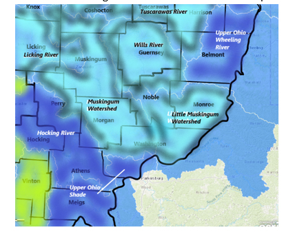
4c Little Muskingum River Watershed
Flows: parts of Washington, Noble, Monroe, Guernsey
- Little Muskingum River drains an area of 210 sq miles of Washington County; at Bloomfield is flowing above normal at 251.47% above mean, 1970 cfs and 9.92 ft deep. (01/12/23)
- Duck Creek drains an area of 260 sq miles in Washington County. The flow below Whipple is unrated, 140.65% above mean, 1380 cfs and 5.46 ft deep (flood stage 12 ft) (updated 01/12/23)
- East Fork Duck Creek drains an area of 99.5 sq miles in Noble County. Flow near Harrietsville not rated, 222.32% above mean at 801 cfs and 8.53 ft deep, (flood stage 17 ft) (updated 01/12/23)
- West Fork Duck Creek drains an area of 84.5 sq miles in Washington County. The flow at Macksburg is not rated, 476.00% above mean at 957 cfs and, 11.82 ft deep (flood stage 13 ft) (updated 01/12/23)
Public Drinking Water Advisories (1)
Woodsfield Village Public Water Supply – Woodsfield – Monroe County – community system serving between 3,301 to 10,000 persons surface water source
Sensitive Population Advisory – Exceeds standards for Disinfection Byproducts – Trihelomethane - By-product of drinking water chlorination
You do not need to use an alternative (e.g. bottled) water supply. However, if you have specific health concerns, consult your doctor.
Locational running annual average of 0.089 mg/L at DS201 for the April 1 to June 30, 2022 time period. MCL = 0.080 mg/l
Spills (0)
- No OEPA spill incident reports uploaded for 2023 as of the week of Jan 9-15, 2023
4d Mohican River Watershed
Flows: catching parts of Richland and Ashland Counties
- Clear Fork Mohican River drains an area of 115 sq miles in Richland County. The streamflow gage
- at Bellville is unrated, 3.73 ft deep, (flood stage 12ft);
- below Pleasant Hill Dam near Perrysville is unrated, 3.46 ft deep; (01/05/23)
- Black Fork Mohican River drains an area of 217 sq miles in Richland County. The flow
- at Shelby is unrated, 377.18% above mean at 632 cfs and 9.89 ft deep (flood stage 15.5 ft);
- below Charles Mill Dam near Mifflin is, 3.79 ft deep (flood stage 1000 ft);
- at Loudonville is 7.69 ft deep (flood stage 10 ft) (01/12/23)
- Lake Fork drains an area of 271 sq miles in Ashland County. The flow below Mohicanville Dam at Mohicanville is up this week, 8.52 ft deep (flood stage 944 ft) (updated 01/12/23)
- Rocky Fork drains an area of 66.7 sq miles of Richland County. The flow at Lucas is 7.07 ft deep. (updated 01/12/23)
Public Drinking Water Advisories (0)
Spills (0)
- No OEPA spill incident reports uploaded for 2023 as of the week of Jan 9-15, 2023
4e Walhonding River Watershed
Flows: parts of Knox, Morrow, Ashland, Richland, Coshocton, Holmes Counties
- Walhonding River drains an area of 2191 sq miles in Coshocton County. The flow
- below Mohawk Dam at Nellie, 8.50 ft deep;
- below Randle is unrated, 3.41 ft deep (01/12/23)
- Kokosing River drains an area of 202 sq miles in Knox County. At Mount Vernon station in Knox County, flow is normal, 36.9% above mean flow at 82 cfs and 2.75 ft deep (flood stage 14ft) (01/12/23)
- Killbuck Creek drains an area of 464 sq miles in Holmes County. The flow at Killbuck in Holmes County is much above normal, 261.82% above mean flow at 1310 cfs and 13.35 ft deep (Flood Stage 15ft). (01/12/23)
Public Drinking Water Advisories (1)
Holmes Cheese Co Public Water System – Millersburg – Holmes County – non-transient system serving less than 250 persons from a groundwater source
Do not Drink advisory – contaminant manganese - Levels > 1 mg/L (Do Not Drink)
Naturally present in the environment; additive in treatment of drinking water contaminants
Spills (0)
- No OEPA spill incident reports uploaded for 2023 as of the week of Jan 9-15, 2023
4f Licking River Watershed
Flows: parts of Licking County
- Licking River drains an area of 537 sq miles of Licking County before joining the Muskingum River. The flow monitor
- near Newark is normal, 0.00% above mean flow at 0.00 cfs and 2.18 ft deep (flood Stage 14ft)
- below Dillon Dam near Dillon Falls the flow is unrated, 7 ft deep. (01/12/23)
- North Fork Licking River drains an area of 241 sq miles of Licking County;
- at Utica in Licking County is high, 824% above mean at 1220 cfs, 10.91 ft deep;
- at Newark, 2.26 ft deep;
- at Ohio Street in Newark the flow is not rated, 8.43 feet deep. (01/12/23)
- South Fork Licking River drains an area of 133 sq miles of Licking County. The station
- at Kirkersville is unrated, 310.70% above historic mean at 254 cfs and 5.57 ft deep;
- near Buckeye Lake flow is unrated, 875.98 ft deep (flood stage 880 ft)
- near Hebron flow is much above normal, 445.74% above historic mean at 1010 cfs and, 7.48 ft deep;
- at Heath the flow is unrated, 15.8% above mean at more than double the volume, 32.1 cfs and 2.76 ft deep. (01/12/23)
- Raccoon Creek drains an area of 78.2 sq miles in Licking County. The flow
- near Granville is unrated, registering 342.15% above mean at 516 cfs and 6.04 ft deep (flood stage 13 ft);
- below Wilson St, Newark, unrated, 26.85% above mean at 89 cfs and 4.25 ft deep (flood stage 16 ft) (updated 01/12/23)
Public Drinking Water Advisories (3)
Potemkin Industries – Mount Vernon – Knox County – non-transient system serving less than 250 persons from a groundwater source
Sensitive Population Advisory – Exceeds standards for inorganic chemical – arsenic from erosion of natural deposits; Runoff from orchards; Runoff from glass and electronics production wastes - MCL = 10 ug/l
You do not need to use an alternative (e.g. bottled) water supply. However, if you have specific health concerns, consult your doctor.
Monitoring/reporting – harmful algal blooms
Public water system has provided insufficent monitoring or reporting information.
Columbia Gas of Ohio – Mount Vernon PWS – Mount Vernon – Knox County non-transient system serving <250 persons from groundwater source
Sensitive Population Advisory – Exceeds standards for Disinfection Byproducts
You do not need to use an alternative (e.g. bottled) water supply. However, if you have specific health concerns, consult your doctor.
Spills (0)
- No OEPA spill incident reports uploaded for 2023 as of the week of Jan 9-15, 2023
4g Muskingum River Watershed
Flows: Morgan, Washington, Noble, Muskingum, Coshocton Counties
- Muskingum River drains an area of 7947 sq miles.
- Near Coshocton in Coshocton County the Upper Muskingum is flowing above normal, 128.23% at 59.5cfs and 2.41 ft deep (flood stage 15ft);
- at Dresden in Muskingum County is flowing above normal, 151.21% above mean at 10300 cfs and 11.45 ft deep (flood Stage 20 ft);
- at Zanesville, unrated, 11.52ft deep (flood stage 25 ft);
- at McConnelsville in Morgan County, the river is flowing above normal, 143.09% above mean at 13500 cfs and 5.85 ft deep (flood stage 11ft).
- at Beverly, unrated, 125.87% above mean at 1880 cfs and 21.24 ft deep (01/12/23)
- Mill Creek drains an area of 27.2 sq miles in Coshocton County. The flow near Coshocton is above normal, 163.68% above mean, 9640 cfs and 10.76 ft deep. (updated 01/12/23)
- Wakatomika Creek drains an area of 140 sq miles in Muskingum County. The flow near Frazeyburg has been monitored for 84 years, is much above normal, 555.43% above mean at 997 cfs and 8.71 ft deep. (updated 01/13/23)
- Salt Creek drains 75.7 sq miles of Muskingum County. Flow at Chandlersville is above normal, rated 123.89% above mean at 554 cfs and 4.89 ft deep. (updated 01/12/23)
Public Drinking Water Advisories (2)
Moose Lodge Water System – Mansfield – Moose Lodge – non-community system serving less than 250 persons from a groundwater source
Boil Water Advisory – exceeds standards for microbacterial contamination – e.coli – source human and animal fecal waste
MCL = confirmed presence of e.coli
Maysville Regional Water – Zanesville – Muskingum County – community system serving between 3301 to 10,000 persons from a surface water source
Sensitive Population Advisory – Exceeds standards for Disinfection Byproducts – Trihelomethane - By-product of drinking water chlorination
You do not need to use an alternative (e.g. bottled) water supply. However, if you have specific health concerns, consult your doctor.
Locational running annual average of 0.100 mg/L at DS201 and 0.120 mg/L at DS202 for the October 1 to December 31, 2022 time period. MCL = .08 mg/L
Spills (0)
- No OEPA spill incident reports uploaded for 2023 as of the week of Jan 9-15, 2023
5 Scioto River Watersheds
5a Upper Scioto Watershed
Flows: trickling over parts of Madison, Union, Franklin, Pickaway, Champaign, Logan, Marion, Delaware, Morrow, Crawford, Licking, Knox, Fairfield Counties
- Upper Scioto River drains an area of 980 sq miles in Marion and Delaware Counties. The flow
- at La Rue in Marion County is above normal, 159.44% above mean at 1080 cfs, and 8.24 ft deep, (flood Stage 12ft);
- at Prospect in Delaware County is above normal, 131.39% above mean at 999 cfs and 4.54 ft deep (flood Stage 12ft), 0.00ºC, µS/cm;
- below O’Shaughnessy Dam near Dublin is above normal, 243.67% above mean at 3300 cfs, 7.11 ft deep;
- at 5th Ave Columbus in Franklin County is unrated, 85.71% above mean flow at 1910 cfs and 9.67 ft deep;
- at Columbus is unrated, 103.34% above mean at 2880 cfs and 10.58 ft deep, (flood stage 24 ft);
- near Commercial Point in Pickaway County the flow is unrated, 129.78% above mean at 6800 cfs and 15.14 ft deep. (01/13/23)
- Mill Creek drains an area of 178 sq miles in Delaware County. The flow at Bellepoint has been monitored for 77 years equipment malfunction (01/13/23)
- Whetsone Creek drains an area of 37.9 sq miles in Morrow County. The flow at Mt. Gilead is unrated, 409.79% above mean at 382 cfs and 4.90 ft deep (flood stage 9 ft) (update 01/13/23)
- Big Walnut Creek drains an area of in Delaware County. The flow
- at Sunbury is much above normal, 490.33% above mean at 1280 cfs and 7.63 ft deep;
- at Central College is normal at 40.17% above mean at 108 cfs, and 3.57 ft deep, (flood stage 11.7 ft);
- at Rees flow is above normal, 228.06% above mean at 1660 cfs and 4.80 ft deep (updated 01/13/23)
- Little Darby Creek drains an area of 162 sq miles in Madison County. The flow at West Jefferson is not rated, 182.81% above mean at 655 cfs and 7.90 ft deep. (01/13/23)
- Big Darby Creek drains an area of 534 sq miles in Pickaway County. The streamflow gauge at Darbyville shows above normal this week,131.81% above mean at 971 cfs and 4.16ft deep. (01/13/23 )
- Hellbranch Run drains an area of 35.8 sq miles in Franklin County. The flow at Harrisburg is normal, 55.59% above historic mean at 77.2 cfs and 5.36 ft deep (01/13/23)
- Alum Creek drains an area of 189 sq miles in Delaware County. The flow
- near Kilbourne is unrated, 564.72% above mean at 705 cfs and 5.21ft deep;
- at Africa is above normal, 251.74% above mean at409 cfs and 2.89 feet deep; 3.0ºC;
- at Columbus is not rated, 4.15 ft deep; (01/13/23)
- Olentangy River drains an area of 157 sq miles in Marion County, 393 sq miles by the time it reaches Delaware. The flow
- at Claridon in Marion County has been monitored for 51 years. Flow is unrated, 8.30 ft deep;
- near Delaware in Delaware County is above normal, 146.22% above mean at 808 cfs and 3.32 ft deep (flood Stage 9ft);
- near Worthington is normal, 162.42% above mean, 1300 cfs and 3.83 ft deep;
- at JH Herrick Dr at Columbus is unrated, 29.84% above mean at 19 cfs and 710.18 ft deep. (01/13/23)
Public Drinking Water Advisories (8)
Oak Hills Mobile Home Park – Grove City – Franklin County – community system serving between 251 and 1000 persons from groundwater source
Sensitive Population Advisory – Exceeds standards for inorganic chemical – arsenic
Source - erosion of natural deposits; Runoff from orchards; Runoff from glass and electronics production wastes - MCL = 10 ug/l
You do not need to use an alternative (e.g. bottled) water supply. However, if you have specific health concerns, consult your doctor.
The running annual average arsenic concentration for arsenic is 0.01 mg/L (11 ug/L) for the fourth quarter of 2022.
McDonalds Restaurant – London – Madison County – community system serving between 251 and 1000 persons from groundwater
Sensitive Population Advisory – Exceeds standards for inorganic chemical – arsenic
Source - erosion of natural deposits; Runoff from orchards; Runoff from glass and electronics production wastes - MCL = 10 ug/l
You do not need to use an alternative (e.g. bottled) water supply. However, if you have specific health concerns, consult your doctor.
99.5 ug/L 90th %
Nex Transport – Building 1 S – East Liberty – Logan County – non-transient system serving less than 250 people from groundwater source
Do Not Drink - Sensitive Populations – Lead
Pregnant and nursing women and young children should not use the water
Lead 90th percentile = 33.6 ug/L (individual lead results: 0.7, 2.5, 7.7, <0.6, 59.4 ug/L).
Brookside Golf and Country Club – non-community system serving 251 to 1000 from a groundwater source
Boil Water Advisory – microbiological contamination – e.coli - Boil the water before using or use bottled water
4 or 5 well source samples collected on 7/20/22 were E.Coli +
Trillium Farms – Croton – Licking County - non-transient system serving less than 250 people from groundwater source
Do Not Drink - Sensitive Populations – Lead – exceeds standard
Pregnant and nursing women and young children should not use the water
LC207 - Water Room Tap - 48 ug/L (90th % = 21 ug/L)
Sensitive Population Advisory – Exceeds standards for inorganic chemical - fluoride
Children under nine should be provided with alternative sources of drinking water or water that has been treated to remove fluoride in order to lessen the risk of cosmetic discoloration of their permanent teeth.
Whispering Pines – Pataskala – Pickaway County – community system serving less than 250 persons from groundwater source
Sensitive Population Advisory – Exceeds standards for inorganic chemical - fluoride
Children under nine should be provided with alternative sources of drinking water or water that has been treated to remove fluoride in order to lessen the risk of cosmetic discoloration of their permanent teeth.
MCL = 4 mg/l and Secondary MCL = 2 mg/l
Mt Victory Village – Mt Victory – Hardin County – community system serving between 251 and 1000 persons from groundwater source
Sensitive Population Advisory – Exceeds standards for inorganic chemical - fluoride
Children under nine should be provided with alternative sources of drinking water or water that has been treated to remove fluoride in order to lessen the risk of cosmetic discoloration of their permanent teeth.
MCL = 4 mg/l and Secondary MCL = 2 mg/l
Spills (0)
- No OEPA spill incident reports uploaded for 2023 as of the week of Jan 9-15, 2023
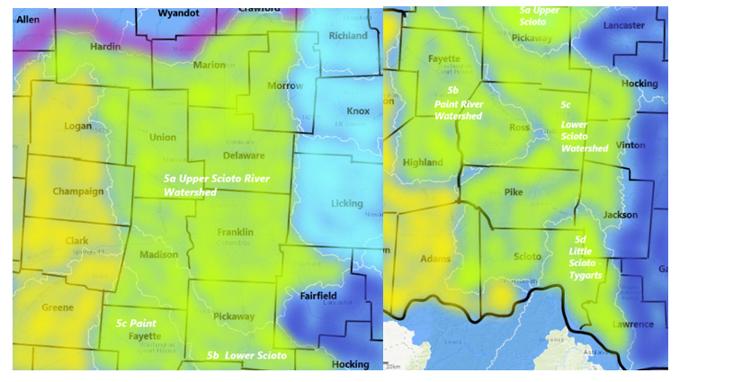
5b Paint Creek Watershed
Flows: parts of Clinton, Ross and Highland Counties
- Paint Creek drains an area of 249 sq miles in Clinton and Ross Counties. The flow
- at Greenfield is above normal, 224.37% above mean, 796 cfs and 4.11 ft deep;
- near Bainbridge is not rated, 4.80 ft deep, 6.3ºC;
- near Bourneville is above normal, 216.77% above mean at 2420 cfs and 5.65 ft deep (flood stage 12 ft);
- at Chillicothe the flow is above normal at 216.64% above historic mean at 4260 cfs and, 10.62 ft deep. (01/13/23)
- Rattlesnake Creek drains an area of 209 sq miles in Highland County. The flow at Centerfield is 5.07 ft deep. (updated 01/13/23)
- Rocky Fork Creek drains an area of 140 sq miles in Highland County. The flow at Barretts Mills is much above normal, 225.14% above mean discharging 434 cfs and 3.66 ft deep. (01/13/23)
Public Drinking Water Advisories (4)
Dollar General #20756 - Mount Sterling – Madison County – non-community system serving less than 250 persons from groundwater source
Boil Water Advisory – microbiological contamination – e.coli
Boil the water before using or use bottled water
Fayette Co – Culpepper Subdivision – Washington – Fayette County - community system serving between 251 and 1000 persons from purchased surface water
Do Not Drink - Sensitive Populations – Lead – exceeds standard
Pregnant and nursing women and young children should not use the water
Action Level = 15 ug/l system test 0.0179 mg/L
Bowersville Village PWS – Bowersville – Greene County - community system serving between 251 and 1000 persons from purchased surface water
Sensitive Population Advisory – Exceeds standards for inorganic chemical - fluoride
Children under nine should be provided with alternative sources of drinking water or water that has been treated to remove fluoride in order to lessen the risk of cosmetic discoloration of their permanent teeth.
MCL = 4 mg/l and Secondary MCL = 2 mg/l
South Solon Village PWS – South Solon – Madison County - community system serving between 251 and 1000 persons from groundwater source
Do Not Drink - Sensitive Populations – Lead – exceeds standard
Pregnant and nursing women and young children should not use the water
Action Level = 15 ug/l
Spills (0)
- No OEPA spill incident reports uploaded for 2023 as of the week of Jan 9-15, 2023
5c Lower Scioto Watershed
Flows: Parts of Madison, Highland, Franklin, Pickaway, Ross and Pike counties
- Scioto River (lower) drains an area of 5836 sq miles from its headwaters in Marion County down to its outlet at the Ohio River.
- The lower end flow at Circleville in Pickaway County is not rated, 130.57% above mean at 8220 cfs and 7.87 ft deep;
- at Chillicothe in Ross County, flow has been monitored for 100 years, flow is above normal, 141.81% at 7110 cfs and 6.02 ft deep (flood stage 16 ft);
- at Higby in Ross County is above normal, 176.36% above mean flow at 11000 cfs and 6.66 ft deep;
- at Piketon in Pike County is not rated, 122.72% above mean, 14400 cfs, and 9.97 ft deep.(flood stage 20 ft) (01/13/23)
- Deer Creek drains an area of 228 sq miles in Madison County. The flow
- at Mount Sterling is much above normal, 267.70% above mean at 906 cfs and 6.35 ft deep;
- near Pancoastburg is not rated and 2.02 ft deep;
- at Williamsport the flow is not rated, 4.88 ft deep (01/13/23)
- Walnut Creek drains an area of 274 sq miles in Pickaway County. The flow at Ashville is unrated, 300.06% above mean, 1770 cfs and 9.98 ft deep. (01/13/23)
- Sunday Creek drains an area of 104 sq miles in Athens County before flowing south and west, joining the Lower Scioto. The flow
- near Burr Oak 6.69 ft deep;
- at Glouster is, 3.84 ft deep (flood stage 16 ft) (updated 01/13/23)
Public Drinking Water Advisories (2)
Cooks Creek Golf Club – Ashville – Pickaway County – non-community system serving less than 250 persons from groundwater source
Boil Water Advisory – microbiological contamination – e.coli
Boil the water before using or use bottled water
MCL = confirmed presence E. coli
Clarksburg Village PWS – Clarksburg – Ross County - community system serving between 251 and 1000 persons from groundwater source
Sensitive Population Advisory – Exceeds standards for inorganic chemical - fluoride
Children under nine should be provided with alternative sources of drinking water or water that has been treated to remove fluoride in order to lessen the risk of cosmetic discoloration of their permanent teeth.
MCL = 4 mg/l and Secondary MCL = 2 mg/l The fluoride result for a sample collected on 1/5/2022 was 2.1 mg/L.
Spills (0)
- No OEPA spill incident reports uploaded for 2023 as of the week of Jan 9-15, 2023
5d Little Scioto – Tygarts Watershed
- Tygart’s Creek drains 242 sq miles in Greenup County flowing north to the Ohio River. The flow near Greenup, KY is above normal flow this week, 213.96% above the mean, 725 cfs, 5.04 ft deep. (01/13/23)
Public Drinking Water Advisories (0)
Spills (0)
- No OEPA spill incident reports uploaded for 2023 as of the week of Jan 9-15, 2023
6 Miami River Watersheds
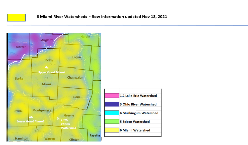
6a Upper Great Miami Watershed
Flows: clearing parts of Hardin, Logan, Shelby, Miami, Darke, Clark and Montgomery Counties
- Great Miami River (Upper) drains an area of 1149 sq miles in Hardin, Logan, Shelby, Miami and Darke and Montgomery Counties. The flow monitoring station closest to the head of the river is at Sidney, in Shelby County. The flow
- at Sidney is much above normal, 325.15% above mean at 2680 cfs and 5.65 ft deep (flood stage 10ft);
- at Piqua flow is unrated, 84.88% over mean, 2810 cfs and 4.44 ft deep (flood stage is 14 ft);
- at Troy is above normal, 174.86% above mean at 5.25 cfs and 5.25 ft deep (flood stage 14 ft);
- at Taylorsville is normal, 99.12% above mean, 1600 cfs and, 4.40 ft deep (flood stage 22 ft) (updated 01/13/23)
- Loramie Creek drains an area of 257 sq miles in Shelby County. The flow
- near Newport is normal, 25.31% above mean, 68.8 cfs and 4.27 ft deep;
- at Lockington in Shelby County is normal, 52.43 % above mean, 199 cfs and 2.19 ft deep. (flood stage 35 ft) (updated 01/13/23)
- Bokengehalas Creek drains an area of 40.4 sq miles of Logan County. The station at de Graff is not rated, 142.31% above mean, 165 cfs and 2.67 ft deep; (updated 01/13/23)
- Mad River drains a combined area of 635 sq miles in Clark, Champaign, Greene and Logan Counties. Flow
- at West Liberty is unrated, 104.59% above mean, 77.0cfs and 3.7 feet deep;
- near Urbana is much above normal, 242.51% above mean 424 cfs and 3.79 ft deep, (flood stage 11 ft);
- at St. Paris Pike is much above normal, 230.22% above mean, 952 cfs and 7.94 ft deep;
- at Springfield is much above normal, 223.27% above mean at 1540 cfs and 2.90 ft deep (flood stage 8ft);
- near Dayton is above normal, 178.67% above mean, 1700 cfs and, 5.23 ft deep (flood stage 25ft) (updated 01/13/23)
- Greenville Creek drains an area of 193 sq miles in Warren and Darke Counties. The flow near Bradford is normal, 35.49% above mean, 78.0 cfs and 3.2 ft deep. (updated 101/13/23)
- Stillwater River drains an area of 503 sq miles in Miami County. The flow
- at Pleasant Hill is normal, 31.30% above mean, 193 cfs and 1.87 ft deep, 4.9ºC;
- at Englewood is normal, 29.90% above mean at 270 cfs and 3.01 ft deep (flood stage 58 ft) (01/13/23)
Public Drinking Water Advisories (6)
"Dec 30 – Clark-Shawnee School, Springfield - The extreme winter temperatures Christmas weekend caused a critical component in the water system to fail, which resulted in depressurization at the Clark-Shawnee Middle and High School and a boil water advisory was issued. The advisory will be in effect until a new water system is installed."
West Charleston Church Of The Brethren – Tipp City – Miami County – non-transient system serving less than 250 from groundwater source
Do Not Drink - Sensitive Populations – Lead – exceeds standard
Pregnant and nursing women and young children should not use the water
Action Level = 15 ug/l Lead 90th percentile 0.016 mg/L.
Liberty Baptist Temple PWS – Springfield – Clark County - non-community system serving less than 250 persons from groundwater source
Boil Water Advisory – microbiological contamination – e.coli
Boil the water before using or use bottled water
MCL = confirmed presence E. coli
Brush Creek Church Of God – Tipp City – Miami County - non-community system serving less than 250 persons from groundwater source
Boil Water Advisory – microbiological contamination – e.coli
Boil the water before using or use bottled water
MCL = confirmed presence E. coli
Voyager Village Mobile Home Park – Dayton – Montgomery County - community system serving less than 250 persons from groundwater source
Sensitive Population Advisory – Exceeds standards for inorganic chemical - fluoride
Children under nine should be provided with alternative sources of drinking water or water that has been treated to remove fluoride in order to lessen the risk of cosmetic discoloration of their permanent teeth.
MCL = 4 mg/l and Secondary MCL = 2 mg/l
Village of South Vienna – South Vienna – Clark County - community system serving between 251 and 1000 persons from groundwater source
Sensitive Population Advisory – Exceeds standards for inorganic chemical – arsenic
Source - erosion of natural deposits; Runoff from orchards; Runoff from glass and electronics production wastes - MCL = 10 ug/l
You do not need to use an alternative (e.g. bottled) water supply. However, if you have specific health concerns, consult your doctor.
Spills (0)
- No OEPA spill incident reports uploaded for 2023 as of the week of Jan 9-15, 2023
6b Lower Great Miami Watersheds
Flows: take off from Hamilton, Montgomery, Preble and Butler Counties
- Great Miami River drains an area of 3838 sq miles in Ohio, with the lower portion taking runoff from sq miles in Hamilton and Butler Counties.
- At Dayton flow is normal, 54.59% above mean at 2280 cfs and 25.85 ft deep (flood stage 41ft);
- at Miamisburg, Montgomery County flow is normal, 69.42% above mean at 2010 cfs and 5.09 ft deep (flood stage 16ft);
- at Franklin the flow is unrated, 23.25% above mean at 1920 cfs and 1.83 ft deep (flood stage 14 ft);
- at Middletown flow is unrated, 15.7% above mean at 612 cfs and 1.89 ft deep(flood stage 12 ft) --°C;
- at Hamilton flow is normal, 85% above mean at 2090 cfs and 2.79 feet deep (flood stage 75ft);
- at Miamitown the flow is unrated, 2.28 ft deep (flood stage 16ft) (updated 01/13/23)
- Wolf Creek drains an area of 68.7 sq miles in Montgomery County into the Great Miami River. The flow at Dayton is normal, 36.31 % above mean flow at 43.9 cfs and 1.68 ft deep (updated 01/13/23)
- Holes Creek drains an area of 18.7 sq miles in Montgomery County into the Great Miami River. The flow near Kettering is unrated, 60.97% above mean at 36.4 cfs and 2.91 ft deep. (updated 01/13/23)
- Twin Creek drains an area of 275 sq miles of Montgomery County into the Great Miami River. The flow near Germantown is below normal, 7.45% above mean at 31.3 cfs and 0.75 ft deep (flood stage 62 ft). (updated 01/13/23)(reading same as two months ago)
- Sevenmile Creek drai1ns 69 sq miles of Preble County into the Great Miami River. The flow at Camden is below normal, 5.10% above mean at 6.26 cfs and 3.49 ft deep. (updated 01/13/23)
Public Drinking Water Advisories (0)
Spills (0)
- No OEPA spill incident reports uploaded for 2023 as of the week of Jan 9-15, 2023
6c Little Miami Watershed
Flows: sending water from Clark, Clermont, Warren and Greene Counties
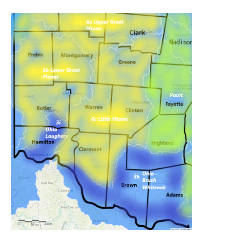
- Little Miami River drains an area of 1203 sq miles in Clark and Greene Counties. The flow
- near Oldtown is much above normal, 299.91% above mean at 460 cfs and, 3.38 ft deep, 5.6°C;
- near Spring Valley is unrated, 4.15 ft deep (flood stage 11ft);
- at Milford is above normal, 176.17% above mean, 3130 cfs, and, 7.78 ft deep (flood stage 17ft) (updated 01/13/23)
- East Fork Little Miami River drains an area of 476 sq miles in Clermont County. Flow
- at Williamsburg is unrated, 774.19% above mean at 2280 cfs and 4.68 ft deep;
- below Harsha Dam near Bantam in Clermont County is 16.02 ft deep, water temperature is 6.8°C;
- at Perintown is normal, 69.29% above mean at 633 cfs and 3.74 ft deep (flood stage 19ft) (updated 01/13/23)
- Massies Creek drains an area of 63.2 sq miles in Greene County into the Little Miami River. The flow monitoring station at Wilberforce is much above normal, 243.99% above mean at 201 cfs and 3.61 ft deep. (updated 01/13/23)
- Caesar Creek drains an area of 239 sq miles in Warren County into the Little Miami River. The flow near Wellman is unrated, 6.21 ft deep and 7.9°C (updated 01/13/23)
- O’Bannon Creek drains an area of 54 sq miles in Clermont County. The flow at Loveland is unrated, 124.35% above mean flow, 190 cfs and 1.95 ft deep; (updated 01/13/23)
Public Drinking Water Advisories (0)
Spills (0)
- No OEPA spill incident reports uploaded for 2023 as of the week of Jan 9-15, 2023
USGS Provisional Data Statement
Data are provisional and subject to revision until they have been thoroughly reviewed and received final approval.
Current condition data relayed by satellite or other telemetry are automatically screened to not display improbable values until they can be verified.
Provisional data may be inaccurate due to instrument malfunctions or physical changes at the measurement site. Subsequent review based on field inspections and measurements may result in significant revisions to the data.
Data users are cautioned to consider carefully the provisional nature of the information before using it for decisions that concern personal or public safety or the conduct of business that involves substantial monetary or operational consequences.
Information concerning the accuracy and appropriate uses of these data or concerning other hydrologic data may be obtained from the USGS.


