|

|
|
 
Bacterial Contamination Alerts - High levels of e.coli are associated with intestinal illness. Ohio Department of Natural Resources, County Health monitor e.coli contamination on public beaches, posting alerts when the levels are above the safe threshold. While the advisory is posted, the beach remains open, however, the public is advised to stay out of the water.
Alerts from the BeachGuard site are reported here in the watershed area, listing the water body impacted, including bacterial contamination and algal toxin sample test results and location details. If you see a bloom, fill out the report on Ohio EPA https://survey123.arcgis.com/share/ac459f1f0b344bfa93c0486b028fbba6 email reports to HABmailbox@epa.ohio.gov
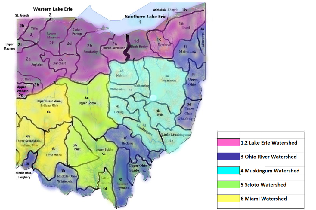
1a Grand River Watershed (0)Draining northeast Ohio north to Lake Erie, including parts of Ashtabula, Lake, Geauga, Portage, Trumbull Counties
1b Ashtabula River - Chagrin River Watershed (0)Draining northeast Ohio, including parts of Ashtabula, Lake, Cuyahoga, Geauga, and Portage Counties north into Lake Erie.
1c Cuyahoga River Watershed (0)Draining a portion of northeast Ohio including parts of Cuyahoga, Summit, Portage, Geauga, and Medina Counties out to Lake Erie.
1d Black River - Rocky River Watershed (0)Draining part of north central Ohio, including parts of Lorain, Ashland, Huron, Cuyahoga, and Medina Counties to Lake Erie.
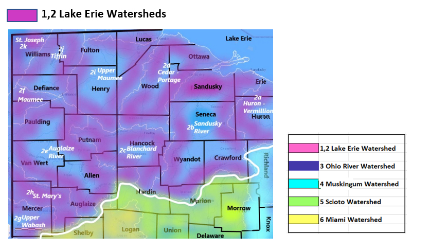
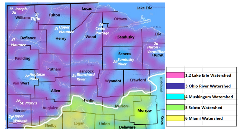
2 Western Lake Erie Watersheds
2a Huron River/Vermillion River (0)Draining parts of north central Ohio, including parts of Erie, Huron, and Lorain Counties north to Lake Erie.
2b Sandusky River Watershed (0)Flows: parts of Sandusky, Seneca, Wyandot, Crawford (4 Main) also parts of Erie, Ottawa, Wood, Huron, Hancock, Hardin, Marion, and Richland counties
2c Blanchard River Watershed (0)Draining parts of Hardin, Hancock, Putnam, Seneca, Allen, and Wyandot Counties north of the divide/height to Lake Erie.
2d Cedar River-Portage River Watershed (1)Draining parts of Hancock, Wood, Seneca, Sandusky, Ottawa Counties to Lake Erie. Lake Erie – Camp Perry (Ottawa County)Bacterial Contamination Advisory issued Aug 31, 8 am ongoing 71 days for high bacteria level, as of Nov 10 Monitoring by Ottawa County Community Health 1 time per week
Sampling test results: (latest test results posted as of Nov 10)
Location: 41.547314/-83.013733
2e Auglaize River Watershed (0 active)Draining an area of northwest Ohio including parts of Defiance, Fulton, Henry, Lucas, Paulding, Williams, Wood and Allen Counties to Lake Erie. 2f - Lower Maumee River Watershed (0)Drainage an area of northwest Ohio, including parts of Defiance, Fulton, Henry, Lucas, Paulding, Williams, and Wood Counties to Lake Erie.
2g Upper Wabash River Watershed (0)Draining an area of northwest Ohio, including parts of Mercer, and Darke Counties west to Indiana. The flows eventually reach Lake Erie. 2h St. Mary’s River Watershed (4)Draining a portion of northwest Ohio west to Indiana, including parts of Mercer, Van Wert, Auglaize, eventually reaching Lake Erie. Chickasaw Creek drains an area of Mercer County into Grand Lake; the Grand Lake outlet flows west to Indiana.
Grand Lake – St. Marys Camp (Auglaize County)Recreational Public Health Advisory issued Aug 17, 5:02 am for Algal bloom/Toxin, 85 days as of Nov 10 Monitoring: Hazardous algae blooms Ohio Department of Natural Resources, as needed
Sampling test results: (latest lab results posted as of Nov 10)
Location: 40.544998/-84.440422
Grand Lake – Windy Point (Auglaize County)Recreational Public Health Advisory issued Aug 17, 5:05 am for Algal bloom/Toxin, ongoing 85 days as of Nov 10 Monitoring: Hazardous algae blooms Ohio Department of Natural Resources, as needed
Sampling test results: (latest lab results posted as of Nov 10)
Location: 40.50946/-84.541168
Grand Lake – St. Marys Main East (Auglaize County)Recreational Public Health Advisory issued Aug 17, 5:03 am ongoing 85 days for Algal bloom/Toxin as of Nov 10 Monitoring: Hazardous algae blooms Ohio Department of Natural Resources, as needed
Sampling test results: (latest test results posted as of Nov 10)
Sampling test results: (latest results posted since Nov 10)
Location: 40.541672/-84.421951
Grand Lake – St. Marys Main West (Auglaize County)Bacterial Contamination Advisory issued Aug 16, 8:22 am ongoing 86 days for high bacteria level, as of Nov 10 Monitoring by Ohio DNR once every two weeks
Sampling test results: (latest lab results posted as of Nov 10)
Sampling test results for algal toxin: (latest lab results posted as of Nov 10)
Location: 40.542671/-84.426231
2i Upper Maumee River Watershed (0)Draining parts of Paulding and Defiance Counties in a northeast flow direction to Lake Erie. Reporting the Lower Maumee section separately under the heading 2f 2j Tiffin River (0)Draining northwest Ohio, parts of Williams, and Defiance Counties, flowing southwest into Indiana, looping back north to Lake Erie in Indiana.
2k St. Joseph River (0)Draining a small corner of northwest Ohio, parts of Williams, Defiance, and Lucas counties, and southwest direction into Indiana.
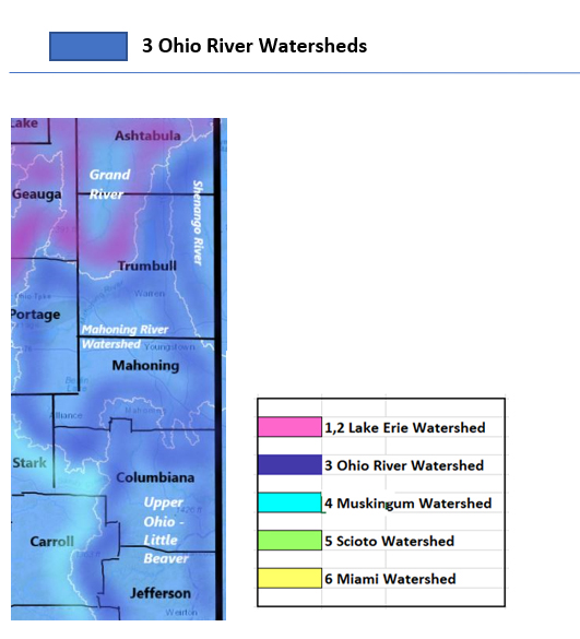
3 Ohio River Tributaries
3a Shenango River Watershed (0)Draining a portion of northeast Ohio including parts of Ashtabula, Trumbull, and Mahoning Counties, flows generally east into Pennsylvania, turning south and eventually joining Ohio River on the Penn side. Note the Shenango River itself does not flow in Ohio state.
3b Mahoning River (0)Draining parts of Stark, Mahoning, and Trumbull counties, Mahoning River draws in the run-off from a large area, flow starts in the south part of the basin, flows north and turns east at Youngstown, exits Ohio, picks up flow from Penn state before joining the Ohio River.
3c Little Beaver Watershed (0)Draining parts of Jefferson, Carroll, Columbiana, and Harrison Counties to the Ohio River.
3d Wheeling Creek Watershed (0)Draining parts of Belmont, and Monroe Counties to the Ohio River.
3e Shade River Watershed (0)Draining parts of Meigs County to the Ohio River.
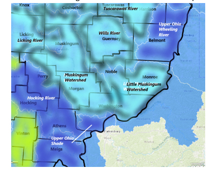
3f Hocking River Watershed (0)Draining a large section of south-central Ohio, including parts of Athens, Hocking, and Fairfield Counties to the Ohio River.
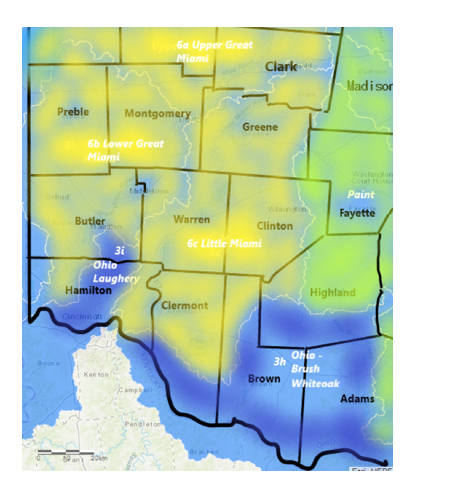
3g Raccoon Creek – Symmes Creek Watershed (0)Draining parts of Hocking, Athens, Meigs, Vinton, Jackson, and Gallia Counties 3h White Oak Watershed (0)Draining a portion of southern Ohio, parts of Brown County to the Ohio River.
3i Laughery Watershed (0)Draining central Butler and Hamilton Counties, including Cincinnati, to the Ohio River.
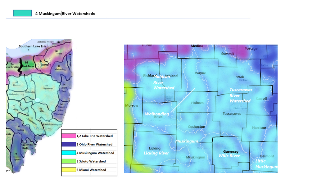
4 Muskingum River Watersheds 4a Tuscarawas River Watershed (0)Draining a large area of east-central interior Ohio generally south, including parts of Tuscarawas, Stark, Wayne, Carroll, and Harrison Counties 4b Wills Creek Watershed (0)Draining parts of Licking, Guernsey, and Tuscarawas Counties. Starting at the southeast corner of the basin, Wills Creek flows north and westward, catching up with the Muskingum River system.
4c Little Muskingum River Watershed (0)Draining parts of Washington, Noble, Monroe, and Guernsey southeast to meet the Ohio River.
4d Mohican River Watershed (0)Draining parts of Richland and Ashland Counties, gathering run-off in a southeast flow direction, joining the Muskingum River.
4e Walhonding River Watershed (0)Draining parts of Knox, Morrow, Ashland, Richland, Coshocton, and Holmes Counties, gathering run-off from a strip of the northern interior state and a strip in the centre of the state, draining these areas together and into the Muskingum system. 4f Licking River Watershed (0)Gathering run-off from parts of Licking County flowing east to the Muskingum channel.
4g Muskingum River Watershed (0)Having gathered the flows of the subregions listed above, Muskingum River continues to clear run-off from parts of Morgan, Washington, Noble, Muskingum, and Coshocton Counties south to the Ohio River.
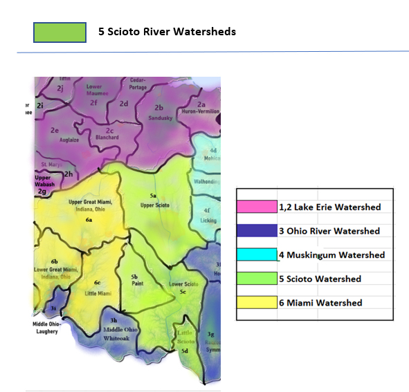
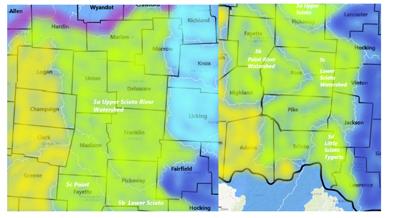
5 Scioto River Watersheds
5a Upper Scioto Watershed (0)Draining parts of Madison, Union, Franklin, Pickaway, Champaign, Logan, Marion, Delaware, Morrow, Crawford, Licking, Knox, Fairfield Counties
5b Paint Creek Watershed (0)Draining parts of Clinton, Ross and Highland Counties
5c Lower Scioto Watershed (1)Draining parts of Madison, Highland, Franklin, Pickaway, Ross and Pike counties Jackson Lake (Jackson County)Bacterial Contamination Advisory issued Sep 2, 11:10 am ongoing 69 days as of Nov 10 for high bacteria level Monitoring by Ohio DNR once every two weeks
Sampling test results: (latest lab results posted as of Nov 10)
Location: 38.901829/-82.5942 5d Little Scioto Watershed (0)Draining the south-most part of Ohio state to the Ohio River.
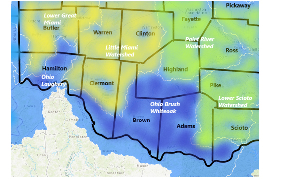
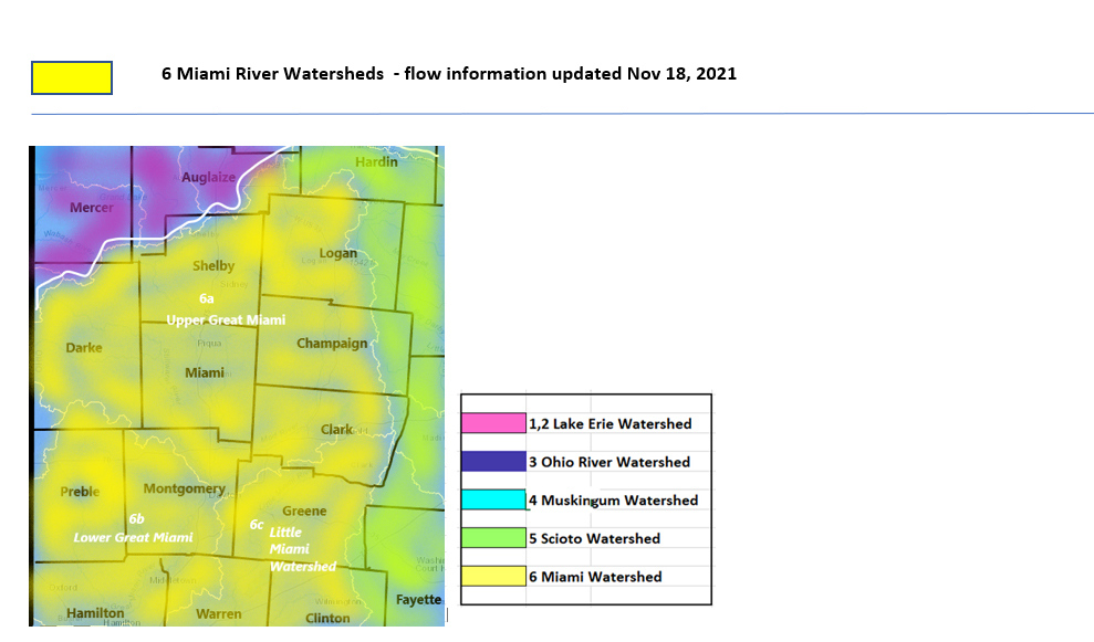
6 Miami River Watersheds
6a Upper Great Miami Watershed (0)Draining a large area in the northwest interior of Ohio, including parts of Hardin, Logan, Shelby, Miami, Darke, Clark and Montgomery Counties. After Dayton, we refer to the Lower Great Miami River, continuing south to the Ohio River.
6b Lower Great Miami Watersheds (0)Draining a large area of interior southwest Ohio, including Hamilton, Montgomery, Preble and Butler Counties to the Ohio River. 6c Little Miami Watershed (0)Draining an area of south interior Ohio east of the Great Miami channel, to flow south and west to meet the Lower Great Miami River and onto the Ohio River, draining parts of Clark, Clermont, Warren and Greene Counties.
|
|
All rights reserved 2026 - WTOH - This material may not be reproduced in whole or in part and may not be distributed, publicly performed, proxy cached or otherwise used, except with express permission. |