Rain brings relief in Huron Vermillion and Erie South watersheds
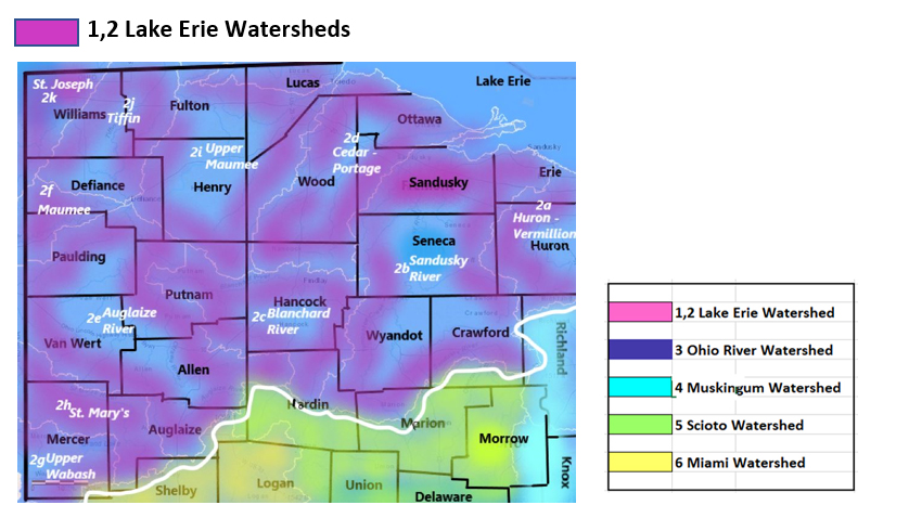
Find your location in Ohio’s Lake Erie drainage basins. Streamflows, hazardous spills and toxic algae impacts can impact downstream drinking water sources for Ohio residents located within the same watershed. Further downstream effects from water impacts in the Lake Erie drainage area can impact Lake Erie and Lake Ontario, which are sources of drinking water for many cities and towns in the northeastern states and Ontario, Canada.
|
Drainage Basin
Lake Erie South
|
Low Flows
|
High Flows
|
HABs
|
Drinking Water Advisories
|
Hazardous Spills
|
|
Grand River
|
0
|
0
|
0
|
2
|
0
|
|
Ashtabula - Chagrin
|
0
|
1
|
0
|
0
|
0
|
|
Cuyahoga River
|
0
|
1
|
0
|
1
|
1
|
|
Black - Rocky
|
0
|
1
|
0
|
0
|
3
|
|
Totals
|
0
|
3
|
0
|
3
|
4
|
Table updated June 12, 2023
- Southern Lake Erie Watersheds
1a Grand River Watershed
Flows: capturing runoff from parts of Ashtabula, Lake, Geauga, Portage, Trumbull Counties
- Grand River drains 685 sq miles in Lake County; the flow is monitored near Painesville, normal flow in this location is less than 3000 cubic feet per second and 5 ft deep. Minor flooding occurs at this location when the water level (gage) passes 12.5 ft. (updated 02-20-23)
Flows (0)
HABs (0)
Public Drinking Water Advisories (2) confirmed ongoing as of June 12, 2023
West Farmington Village Public Water Supply (Trumbull) Sensitive population advisory issued by Ohio EPA: exceeds standard for haloacetic acids (HAA5), by-products of disinfection MCL = 0.06 mg/L. This is a community water system serving between 251 and 1000 customers (908 customers) from a surface water source (surface water intake on Grand River, also surface water purchased from Trumbull County) Measured running average HAA5 .061 mg/L.
DFC Mobile Home Park – Jefferson (Ashtabula) Boil Water Advisory has been issued due to measured e.coli microbiological contamination in the well water. Residents of DFC Mobile Home Park are advised to boil water before drinking or use an alternate water source.
Spills (0)
- No hazardous spills found for the search period of June 5th – 11th 2023
1b Ashtabula River - Chagrin River Watershed
Flows: catching parts of Ashtabula, Lake, Cuyahoga, Geauga, Portage Counties
Conneaut Creek drains an area of 175 sq miles in Ashtabula County; the creek is monitored at Conneaut station, the normal flow at this location is below 1000 cfs and 4.5 ft deep; temperature is monitored, flood stage is not reported
Chagrin River drains an area of 246 sq miles of Lake County into Lake Erie. Normal flow at Willoughby station is below 1100 cfs and 4.5 ft deep (flood stage 12 ft)
Unnamed tributary to Chagrin River drains 7.69 sq miles of Cuyahoga County. The flow
- at Pepper Pike is unrated, has been measured at 6.75 ft deep
- at Mayfield Village is unrated, has measured 1 ft deep (04-10-23)
Euclid Creek drains an area of 5.13 sq miles in Cuyahoga County. The flow
- - at South Euclid is unrated, has been 0.75 ft deep; at Cleveland is unrated, has measured around 50 cfs and 2.5 ft deep East Branch at
East Branch Euclid Creek drains 7.11 sq miles in Cuyahoga County. Flow at Richmond Heights is unrated, has been 1.5 ft deep
- (section updated 04-10-23)
High Flows (1)
June 12 11:00 am EDT Chagrin River is flowing much above normal at Willoughby - flow depth is 4.23 ft at 786 cubic feet per second
HABs (0)
Public Drinking Water Advisories (0)
Spills (0)
- No hazardous spills found for the search period of June 5th – 11th 2023
1c Cuyahoga River Watershed
Flows: parts of Cuyahoga, Summit, Portage, Geauga, Medina Counties
Cuyahoga River drains an area of 788 sq miles in Ohio. With its headwaters in Geauga County, Cuyahoga takes a loop south into Portage and then hooks back north through Summit, passing through Cuyahoga County to discharge into Lake Erie.
- At Hiram Rapids, the nearest monitoring station to the headwaters in Geauga County, the normal flow is around 390 cfs and 2.8 ft deep (flood stage 7ft);
- at Old Portage, a normal flow is less than 800 cfs and 4.5 feet deep (flood at 10.5ft);
- at Jaite station, the flow is unrated, it has been measured at 1360 cfs and 4.9 ft deep, temperature is monitored at this location
- at Independence station, normal flow is less than 1800 cfs and 6 ft deep, (flood at 17 ft), temp and specific conductance are measured here;
- at the Newburgh Heights station nearest the outlet in Cuyahoga County the flow is unrated, this location has been logged at 2000 cfs; temp is monitored here (updated 03-02-23)
West Creek drains an area of 9.23 sq miles in Cuyahoga County. The flow
- at Pleasant Valley Rd near Parma is unrated, it has measured 9.5 ft deep (8.85 ft is minimum operating limit);
- at Ridgewood Road, Parma is unrated, it has been known to flow 5 ft deep (flood stage 10ft);
- at Brooklyn Heights (nearest to the outlet) is also unrated, we have seen it at 22 cfs and 1.5 ft deep. (updated 03-02-23)
Mill Creek gathers runoff and drains 12.9 sq miles in the Cuyahoga River watershed; the flow
- at Garfield Heights is unrated, it can be around 28 cfs and 1.1 ft deep;
- at Garfield Parkway flow is unrated, it has been measured at 29.5 cfs and 1.8 ft deep (flood stage 7.5 ft) (updated 03-02-23)
Big Creek drains an area of 35.3 sq miles in Cuyahoga County. The flow at Cleveland is unrated, has been 89 cfs and 3.6 ft deep. (updated 03-02-23)
East Branch Big Creek collects flow from 19.2 sq miles in Cuyahoga County. The flow at Brooklyn is unrated, can be 39 cfs and 2.6 ft deep. (updated 03-02-23)
Brandywine Creek drains an area of 16.4 sq miles in Summit County. The flow near Macedonia is unrated, we have seen it at 50 cfs and 3.7 ft deep, (minor flood stage here is 13 ft). (updated 03-02-23)
Indian Creek drains an area of 4.49 sq miles in Cuyahoga County. The flow at Macedonia is unrated, has been 9 cfs and 1.5 ft deep (flood stage 9.5ft) (updated 03-02-23)
Tinkers Creek drains an area of 83.9 sq miles of Cuyahoga County, flow at Bedford is above normal, 220.66% above mean at 399 cfs and 3.60 ft deep (flood at 9.5 ft). (updated 01/30/23)
Chippewa Creek drains an area of 17.5 sq miles Cuyahoga County before joining the Cuyahoga River. The flow near Brecksville is unrated, it can be around 3 ft deep (updated 03-02-23)
Doan Brook drains an area of 8.2 sq miles in Cuyahoga County. The flow at MLK Jr. Dr Cleveland is unrated, we see it at around 15 cfs and 2 ft deep. (updated 04-10-23)
High Flows (1)
June 12 11:00 am EDT Tinkers Creek is flowing much above normal near Bedford - flow depth is 4.03 ft at 581 cubic feet per second
HABs (0)
Public Drinking Water Advisories (1)
June 11 – Akron (Summit) – Boil Water Advisory issued by the City of Akron for 1,000 North Akron water customers after a water main break on Cuyahoga Street caused water pressure to fall Saturday evening.
Spills (1)
- June 11 - unknown amount of hydraulic oil reported spilled in Garfield Heights - Cuyahoga - Mill Creek affected *
1d Black River - Rocky River Watershed
Flows: runs off parts of Lorain, Ashland, Huron, Cuyahoga, Medina Counties
Black River drains an area of 396 sq miles of Lorain County into Lake Erie. Normal flow at Elyria is around 1100 cfs and 4 ft deep. (flood stage 9.5 ft) 2.5°C. Specific conductance 471 µS/cm. (updated 05-12-23)
Rocky River drains an area of 267 sq miles of Cuyahoga County into Lake Erie. Normal flow at Berea is around 300 cfs and 5 ft deep, (flood stage 14 ft), temperature is recorded here (updated 04-12-23)
East Branch Rocky River drains an area of 60.3 sq miles in Cuyahoga County. The flow near Strongsville is unrated, usually around 70 cfs and 6 ft deep when conditions in the area are normal. (update 04-12-23)
Plum Creek drains 15.7 sq miles in Cuyahoga County. The flow near Olmstead Falls is unrated, around 10-12 cfs and 2 ft deep (flood at 8ft). (updated 04-12-23)
Abram Creek drains an area of 8.12 sq miles in Cuyahoga County. The flow
- at Kolthoff Dr./Brook Park is unrated, 0.5 ft deep;
- at Brook Park is not rated, 1.5 ft deep (min operating limit .19ft) (updated 04-12-23)
Baldwin Creek drains an area of 8.9 sq miles in Cuyahoga County. The flow at Strongsville is unrated, we see this station measuring around 2.5 ft deep. (updated 04-12-23)
High Flows (1)
June 12 11:00 am EDT Rocky River is flowing much above normal near Berea - flow depth is 8.14 ft at 659 cubic feet per second
HABs (0)
Public Drinking Water Advisories (0)
Spills (3)
- June 10 - unknown amount of unknown petroleum spilled with sheen reported in Lorain - Lorain - Black River affected *
- June 9 - unknown amount of petroleum oil reported spilled in Cleveland – Cuyahoga
- June 5 - unknown amount of gasoline reported spilled in Olmsted Township - Cuyahoga
2 Western Lake Erie Watersheds

|
Drainage Basins
Lake Erie West
|
Low Flows
|
High Flows
|
HABs
|
Drinking Water Advisories
|
Hazardous Spills
|
|
Huron - Vermillion
|
0
|
2
|
0
|
0
|
0
|
|
Sandusky River
|
0
|
0
|
1
|
1
|
0
|
|
Blanchard River
|
0
|
0
|
0
|
1
|
0
|
|
Cedar-Portage
|
0
|
0
|
0
|
0
|
0
|
|
Auglaize River
|
1
|
0
|
0
|
4
|
0
|
|
Lower Maumee
|
1
|
0
|
1
|
5
|
2
|
|
Upper Wabash
|
0
|
0
|
0
|
0
|
0
|
|
St Marys
|
0
|
0
|
4
|
1
|
0
|
|
Upper Maumee
|
1
|
0
|
0
|
3
|
0
|
|
Tiffin River
|
1
|
0
|
0
|
0
|
0
|
|
St Joseph River
|
0
|
0
|
0
|
0
|
0
|
|
Totals
|
4
|
2
|
6
|
15
|
2
|
Table updated June 12, 2023
2a Huron River/Vermillion River
Flows: parts of Erie, Huron, Lorain Counties
Vermillion River drains an area of 262 sq miles of Lorain County into Lake Erie just east of Sandusky Bay. Normal flow at the Vermillion monitoring station is around 200 cfs and 2.7 ft deep (flood stage 9ft); (updated 04-12-23)
Huron River drains an area of 371 sq miles of Huron County into Lake Erie east of Sandusky Bay. Normal flow at Milan station is around 300 cfs and 7 ft deep, (flood stage is 18 ft). temp and conductance are detected here(updated 04-12-23)
Old Woman Creek drains 22.1 sq miles in Erie County. At Berlin Rd near Huron, normal flow is 5 cfs and 2 ft deep (updated 04-12-23)
High Flows (2)
June 12 11:00 am EDT Old Woman Creek is flowing much above normal at Berlin Rd near Huron - flow depth is 1.35 ft at 384 cubic feet per second
June 12 11:00 am EDT Huron River is flowing much above normal near Milan - flow depth is 8.41 ft at 653 cubic feet per second
Public Drinking Water Advisories (0)
HABs (0)
Spills (0)
- No hazardous spills found for the search period of June 5th – 11th 2023
2b Sandusky River Watershed
Flows: parts of Sandusky, Seneca, Wyandot, Crawford (4 Main) also parts of Erie, Ottawa, Wood, Huron, Hancock, Hardin, Marion, and Richland counties
Sandusky River drains an area of 1251 sq miles in Crawford and Wyandot Counties. The flow
- near Bucyrus in Crawford County normal flow is around 30 cfs and 1 ft deep (floods at 8.5 ft);
- near Upper Sandusky normal flow is around 250 cfs and 2 ft deep (flood at 13 ft);
- at Fremont, normal flow is up to 1100 cfs and 2.2 ft deep (floods at 10ft); (04-12-23)
Honey Creek drains an area of 149 sq miles of Seneca County into Sandusky River. Normal flow at Melmore in Seneca County is less than 90 cfs and 2.5 ft deep. (04-12-23)
Rock Creek drains an area of 34.6 sq miles in Seneca County into Sandusky River. The flow
- at Republic flow is unrated, just a trickle at 1.5 cfs and 3.8 ft deep;
- at Tiffin normal flow is around 10 cfs and 3.8 ft deep (updated 04-12-23)
Tymochtee Creek drains an area of 229 sq miles in Wyandot County into Sandusky River. Normal flow at Crawford is around 125 cfs and 2.75 ft deep (flood stage 8.5 ft). (updated 04-12-23)
Flows (0)
Public Drinking Water Advisories (1) updated as of June 5, 2023
Tiffin Loader Crane Company – Tiffin – Seneca County - non-transient system less than 250 persons from groundwater source
Monitoring/Reporting advisory - Public water system has provided insufficient monitoring or reporting information.
Contaminant of concern: inorganic chemicals (IOC’s): nitrite
HABs (1)
June 12 10:00 am EDT- Sandusky Bay - June 11 image is obscured by cloud cover - June 10 image showed bloom activity in Sandusky Bay starting at 750 thousand cells per 100 ml at the mouth of the bay and increasing in concentration to one million cells per 100ml at the shoreline inside Sandusky Bay - Winds above 4.0 mph may begin mixing the bloom and clouds may obscure it, leading to an underestimate of the area. Moderate and low concentrations may not be obvious to the eye. Composited Cyanobacteria Index as reported by National Centers for Coastal Ocean Science, a visual scale based on true color imagery from the Copernicus- Sentinel 3a satellite of the EUMETSAT June 11
Spills (0)
- No hazardous spills found for the search period of June 5th – 11th 2023
2c Blanchard River Watershed
Flows: drains parts of Hardin, Hancock, Putnam, Seneca, Allen, Wyandot Counties
Blanchard River drains 756 sq miles of Hancock and Putnam Counties into Auglaize River and on to Lake Erie. The flow measured
- nearest the headwaters below Mt. Blanchard flow is unrated, around 50 cfs and 3.3 ft deep (flood at 14 ft);
- above Findlay flow is unrated, 40 cfs and 5.5 ft deep;
- near Findlay normal flow is around 100 cfs and 1.5 ft deep.
- at Gilboa in Putnam County flow is unrated, common to see this around 150 cfs and 5 ft deep;
- at Ottawa in Putnam County flow is unrated, can be around 220 cfs and 8 ft deep when upstream conditions are normal;
- near Dupont flow is unrated, around 500 cfs and 9 ft deep (updated 04-12-23)
Lye Creek drains an area of 18.8 sq miles. The flow above Findlay is unrated, starts out around 6 cfs and 1.5 ft deep (flood stage is 6ft). (04-12-23)
Eagle Creek drains an area of 51 sq miles in Hancock County. Flow above Findlay is unrated, commonly 15 cfs and 3.4 ft deep when (flood stage is 9ft) temp and conductance are measured here (updated 04-12-23)
Riley Creek drains an area of 70.3 sq miles in Putnam County. The flow below Pandora is unrated, around 40 cfs and 3.7 ft deep. (updated 04-12-23)
Flows (0)
HABs (0)
Public Drinking Water Advisories (1) confirmed ongoing as of June 12, 2023
McComb Village – McComb – Hancock County – Community system serving 1001 – 3300 persons – surface water source
Sensitive population advisory – disinfection byproducts – haloacetic acids
You do not need to use an alternative (e.g. bottled) water supply. However, if you have specific health concerns, consult your doctor.
Spills (0)
- No hazardous spills found for the search period of June 5th – 11th 2023
2d Cedar River-Portage River Watershed
Flows: catches parts of Hancock, Wood, Seneca, Sandusky, Ottawa Counties
Portage River drains an area of 494 sq miles of Sandusky County. The flow
- at Woodville normal flow is around 350 cfs and 3.5 ft deep (flood stage 9ft) temp is recorded here;
- near Elmore the flow is unrated, commonly around 500 cfs and 3.5 ft deep when flow at Woodville is normal (flood stage 12 ft) (updated 04-12-23)
Flows (0)
Public Drinking Water Advisories (0)
HABs (0)
Spills (0)
- No hazardous spills found for the search period of June 5th – 11th 2023
2e Auglaize River Watershed
Flows: washes parts of Defiance, Fulton, Henry, Lucas, Paulding, Williams, Wood and Allen Counties
Auglaize River drains an area of 2318 sq miles into Maumee River, where it empties into the western part of Lake Erie. The flow station
- closest to headwaters is at Kossuth in Allen County. Flow here is unrated, around 135 cfs and 5.5 ft deep;
- near Fort Jennings station normal flow is around 200 cfs and 3 ft deep (flood stage 13 ft);
- near Dupont flow is unrated, 15 ft deep is standard;
- near Defiance normal flow is under 2000 cfs and 8 ft deep (flood stage 21 ft) (updated 04-12-23)
Little Flat Rock Creek drains an area of 15.2 sq miles in Paulding County into Auglaize River. The flow near Junction is unrated, around 6 cfs and, 2.5 ft deep. (updated 04-12-23)
Little Auglaize River drains an area of 401 sq miles in Paulding County into Auglaize River. The flow at Melrose is unrated, common to see this around 380 cfs and 13.5 ft deep. (updated 04-12-23)
Low Flows (1)
June 12 11:00 am EDT Auglaize River is flowing below normal at Defiance - down overnight - 5.39 ft deep at 58.1 cubic feet per second
Public Drinking Water Advisories (4) confirmed ongoing as of June 12, 2023
Van Wert City – Van Wert – Van Wert County – Community system serving 10,001 up to 50,000 persons – surface water source
Sensitive Populations Advisory - Disinfection Byproducts (DBPs) - Trihalomethanes, total
You do not need to use an alternative (e.g. bottled) water supply. However, if you have specific health concerns, consult your doctor.
Locational running annual average of 0.083 mg/L at DS201 and 0.081 mg/L at DS202 during the July 1 to September 30, 2022 time period. MCL = .08 mg/L
Some people who drink water containing trihalomethanes in excess of the MCL over many years may experience problems with their liver, kidneys, or central nervous systems, and may have an increased risk of getting cancer.
Grover Hill Elementary School – Paulding – Paulding County – Non-Transient system serving between 251 and 1000 persons – groundwater source
Do not Drink – sensitive population – inorganic chemicals - fluoride
Children under nine should be provided with alternative sources of drinking water or water that has been treated to remove fluoride in order to lessen the risk of cosmetic discoloration of their permanent teeth. MCL = 4 mg/l and Secondary MCL = 2 mg/l
Major source: Erosion of natural deposits; Water additive; Discharge from fertilizer and aluminum factories
Oakwood Village – Oakwood – Paulding County – Community system serving between 251 and 1000 persons – groundwater source
Do Not Drink - Sensitive Populations – for inorganic chemicals contaminant – fluoride
Children under nine should be provided with alternative sources of drinking water or water that has been treated to remove fluoride in order to lessen the risk of cosmetic discoloration of their permanent teeth. MCL = 4 mg/l and Secondary MCL = 2 mg/l
The result of the 2019 fluoride sample was 2.07 mg/L. Verification of public notice was received on February 2, 2021.
Major source: Erosion of natural deposits; Water additive; Discharge from fertilizer and aluminum factories
Waynesfield Village – Waynesfield – Auglaize County - Community system serving between 251 and 1000 persons – groundwater source
Do Not Drink - Sensitive Populations – for inorganic chemicals contaminant – fluoride
Children under nine should be provided with alternative sources of drinking water or water that has been treated to remove fluoride in order to lessen the risk of cosmetic discoloration of their permanent teeth. MCL = 4 mg/l and Secondary MCL = 2 mg/l
Major source: Erosion of natural deposits; Water additive; Discharge from fertilizer and aluminum factories
HABs(0)
Spills (0)
- No hazardous spills found for the search period of June 5th – 11th 2023
2f - Lower Maumee River Watershed
Flows: streams from parts of Defiance, Fulton, Henry, Lucas, Paulding, Williams, Wood Counties
Maumee River drains an area of 6330 sq miles of Ohio State. The lower portion normal flow at Waterville flow is around 4000 cfs and 4.5 ft deep; temp and conductance measured here (flood stage 11 ft) (updated 04-12-23)
Ottawa River drains an area of 350 sq miles in Lucas County directly into western Lake Erie. The flow
- near Lima is unrated, commonly around 15 cfs and, 11.5 ft deep;
- near Kalida is unrated, around 200 cfs and 5 ft deep.
- University of Toledo at Toledo, normal flow is around 120 cfs and 4 ft deep (flood stage 14.5 ft) (update 04-12-23)
Wolf Creek drains an area of 24.8 sq miles in Lucas County. The flow at Holland is unrated, around 20 cfs and 2 ft deep (flood stage 13 ft). (updated 04-12-23)
West Creek drains an area of 15.5 sq miles of Henry County before joining the Maumee River. Normal flow near Hamler is around 12 cfs and 3.5 ft deep. (updated 04-12-23)
South Turkeyfoot Creek drains an area of 116 sq miles of Henry County before joining the Maumee River. Flow at Shunk is unrated, commonly around 140 cfs and 2.5 ft deep. (updated 04-12-23)
Low flows (1)
June 12 11:00 am EDT Maumee River is flowing much below normal at Waterville - flow depth is 1.99 ft at 542 cubic feet per second
Public Drinking Water Advisories (5) confirmed ongoing as of June 12, 2023
Leipsic Village – Leipsic – Putnam County – Community system serving between 1001 and 3,300 persons with groundwater
Do Not Drink - Sensitive Populations – for inorganic chemicals contaminant – fluoride
Children under nine should be provided with alternative sources of drinking water or water that has been treated to remove fluoride in order to lessen the risk of cosmetic discoloration of their permanent teeth. MCL = 4 mg/l and Secondary MCL = 2 mg/l
The 2019 fluoride result was 2.68 mg/L. The annual Public Notice was delivered in the Consumer Confidence Report in March 2021. MCL = 4 mg/L Secondary MCL = 2 mg/L
Whispering Winds Mobile Home Community – Grand Rapids – Lucas County - Community system serving less than 250 persons from a groundwater source
Do Not Drink - Sensitive Populations – for inorganic chemicals contaminant – fluoride
Children under nine should be provided with alternative sources of drinking water or water that has been treated to remove fluoride in order to lessen the risk of cosmetic discoloration of their permanent teeth. MCL = 4 mg/l and Secondary MCL = 2 mg/l
LHS Maumee Youth Center - Liberty Center – Henry County - Community system serving less than 250 persons from a groundwater source
Do Not Drink - Sensitive Populations – for inorganic chemicals contaminant – fluoride
Children under nine should be provided with alternative sources of drinking water or water that has been treated to remove fluoride in order to lessen the risk of cosmetic discoloration of their permanent teeth. MCL = 4 mg/l and Secondary MCL = 2 mg/l
The annual average fluoride concentration in 2020 was 3.06 mg/L.
Holgate Village - Holgate – Henry County – community system serving between 1001 and 3,300 from a groundwater source
Sensitive Population Advisory – Exceeds standards for Disinfection Byproducts – Trihalomethane - By-product of drinking water chlorination
You do not need to use an alternative (e.g. bottled) water supply. However, if you have specific health concerns, consult your doctor.
Locational running annual average of 0.101 mg/L at DS201 and 0.106 mg/L at DS202 during the July 1 to September 30, 2022 time period.
Do Not Drink - Sensitive Populations – for inorganic chemicals contaminant – fluoride
Children under nine should be provided with alternative sources of drinking water or water that has been treated to remove fluoride in order to lessen the risk of cosmetic discoloration of their permanent teeth. MCL = 4 mg/l and Secondary MCL = 2 mg/l
McGuffey Village – McGuffey – Hardin County – community system serving between 251 and 1000 persons from a groundwater source
Do Not Drink - Sensitive Populations – for inorganic chemicals contaminant – fluoride
Children under nine should be provided with alternative sources of drinking water or water that has been treated to remove fluoride in order to lessen the risk of cosmetic discoloration of their permanent teeth. MCL = 4 mg/l and Secondary MCL = 2 mg/l
HABs (1)
June 12 10:00 am EDT Western Basin Lake Erie - Toledo area satellite image for June 11 is largely obscured by cloud cover - bloom activity in the range of 500 thousand cells per 100 ml is visible between patches of cloud - note that winds above 4.0 mph may begin mixing the bloom and clouds may obscure it, leading to an underestimate of the area. Moderate and low concentrations may not be obvious to the eye. Composited Cyanobacteria Index as reported by National Centers for Coastal Ocean Science, a visual scale based on true color imagery from the Copernicus- Sentinel 3a satellite of the EUMETSAT June 11
Spills (2)
- June 5 - 5 gallons of paint reported spilled in York Township - Fulton - North Turkeyfoot affected *
- June 11 - 150 gallons of diesel fuel reported spilled in Sylvania Township - Lucas
2g Upper Wabash River Watershed
Flows: from parts of Mercer, Darke Counties
The headwaters of the Wabash River are in Ohio, however, USGS does not monitor flows on this system in the state of Ohio. Spills and weather incidents in this area will be noted as they occur, the residue flows west out of state.
Flows (0)
Public Drinking Water Advisories (0)
HABs (0)
Spills (0)
- No hazardous spills found for the search period of June 5th – 11th 2023
2h St. Mary’s River Watershed
Flows from Mercer, Van Wert, Auglaize
St. Mary’s River drains an area of 386 sq miles in Mercer and Van Wert Counties. From the headwaters in Mercer County, St. Mary’s flows west into Indiana into the Maumee River, which crosses back into Ohio and empties into Lake Erie. The flow
- at Rockford is flow is unrated, around 350 cfs and 5.5 ft deep (flood stage 13 ft);
- at Walcot Street at Willshire flow is unrated, around 500 cfs and 5 ft deep. (updated 04-12-23)
Chickasaw Creek drains an area of 16.4 sq ft of Mercer County. Normal flow at St Marys is around 1 cfs and 3 ft deep (update 04-12-23)
Flows (0)
Public Drinking Water Advisories (1) confirmed ongoing as of June 12, 2023
Marion Local High School – Maria Stein – Mercer County – non-transient system serving between 251 and 1000 persons with groundwater
Do Not Drink Advisory for Sensitive Populations – for exceed standards inorganic chemicals contaminant – fluoride
Children under nine should be provided with alternative sources of drinking water or water that has been treated to remove fluoride in order to lessen the risk of cosmetic discoloration of their permanent teeth. MCL = 4 mg/l and Secondary MCL = 2 mg/l
The result of the sample collected on August 15, 2018 was 2.07 mg/L.
Major source: Erosion of natural deposits; water additive; Discharge from fertilizer and aluminum factories
Hazardous Algae Blooms (4) Recreational Public Health Advisories have been issued for the following beaches effective May 15, 2023
- June 12 11:00 am EDT - Grand Lake - St. Mary's Camp - Recreational Public Health Advisory issued for algal bloom - toxin, ongoing from May 15 - June 5 sample testing finds microcystin at 20.2 ug/l - sampling done by Ohio Dept of Natural Resources on June 4 indicates e.coli results are down to 21.1 cfu from 53.8 cfu/100ml measured May 21
- June 12 11:00 am EDT - Grand Lake - St Marys Windy Point Recreational Public Health Advisory issued for hazardous algae bloom, ongoing from May 15 - June 5 test for algal toxin has microcystin at 23.2 ug/l - sampling done by Ohio Dept of Natural Resources on June 4 indicates e.coli at 83.3 cfu/100ml
- June 12 11:00 am EDT - Grand Lake – St Marys Main East Beach - Recreational Public Health Advisory issued for algal bloom - toxin, ongoing from May 15 - June 5 lab test for algal toxin microcystin came out at 22.3 ug/l - sampling done by Ohio Dept of Natural Resources on June 4 indicates e.coli at 14.4 cfu - down from 17.1 cfu/100ml on May 21
- June 12 11:00 am EDT Grand Lake - Main West Beach - Recreational Public Health Advisory issued for algal bloom - toxin, ongoing from May 15 - lab test on June 5 sample shows algal toxin microcystin at 48.5 ug/lsampling done by Ohio Dept of Natural Resources on June 4 indicates e.coli at 307.6 cfu - up from 9.8 cfu/100ml on May 21
Spills (0)
- No hazardous spills found for the search period of June 5th – 11th 2023
2i Upper Maumee River Watershed
Flows: parts of Paulding and Defiance Counties
Maumee River drains an area of 2129 sq miles of Paulding County. The flow
- at Antwerp in Paulding County normal flow is around 1900 cfs and 9 ft deep; temp and conductance are collected here;
- near Defiance normal flow is around 2800 cfs and up to 3 ft deep (flood at 14 ft), temp is recorded here (flood stage 14 ft)(updated 04-12-23)
Platter Creek drains an area of 19.5 sq miles of Defiance County into Maumee River. Flow near Sherwood is unrated, commonly around 10 cfs and 2 ft deep. (updated 04-12-23)
Low Flows (1)
June 12 11:00 am EDT Maumee River is flowing much below normal near Defiance - down significantly overnight - running 1.7 ft deep at 238 cubic feet per second
Public Drinking Water Advisories (3) locations confirmed ongoing as of June 12, 2023
Hamler Village – Marion St – Henry County – this is a community system serving between 251 and 1000 persons from a groundwater source
Dec 6, 2021 - Sensitive Population Advisory – Exceeds standards for Disinfection Byproducts – Trihalomethane - By-product of drinking water chlorination
Locational running annual average of 0.120 mg/L at DS201 and 0.084 mg/L at DS202 during the July 1 to September 30, 2022 time period. MCL = .08 mg/L
Jan 1, 1992 - Sensitive Population Advisory – Exceeds standards for inorganic chemical - fluoride –
Children under nine should be provided with alternative sources of drinking water or water that has been treated to remove fluoride in order to lessen the risk of cosmetic discoloration of their permanent teeth.
The most recent fluoride result was 2.39 mg/L in 2018. The most recent distribution of the public notice was in July 2020.
Hamler Village – Hubbard St – Henry County - community system serving between 251 and 1000 persons with groundwater source
Dec 6, 2021 - Sensitive Population Advisory – Exceeds standards for Disinfection Byproducts – Trihalomethane - By-product of drinking water chlorination
Locational running annual average of 0.120 mg/L at DS201 and 0.084 mg/L at DS202 during the July 1 to September 30, 2022 time period. MCL = .08 mg/L
Jan 1, 1992 - Sensitive Population Advisory – Exceeds standards for inorganic chemical - fluoride –
Children under nine should be provided with alternative sources of drinking water or water that has been treated to remove fluoride in order to lessen the risk of cosmetic discoloration of their permanent teeth.
The most recent fluoride result was 2.39 mg/L in 2018. The most recent distribution of the public notice was in July 2020.
Campbells Soup Supply Co – Napoleon – Henry County – non-transient system serving between 1001 and 3300 persons with surface water
Sensitive Population Advisory – Exceeds standards for Disinfection Byproducts – Trihalomethane - By-product of drinking water chlorination
You do not need to use an alternative (e.g. bottled) water supply. However, if you have specific health concerns, consult your doctor.
Locational running annual average of 0.112 mg/L at DS201 and 0.087 mg/L at DS202 during the July 1 to September 30, 2022 time period. MCL = .08 mg/L
HABs(0)
Spills (0)
- No hazardous spills found for the search period of June 5th – 11th 2023
2j Tiffin River
Flows: wetting parts of Williams, Defiance Counties
Tiffin River flows south and gathers in runoff from an area of 563 sq miles in Williams and Defiance Counties before joining the Maumee River which empties into the western basin of Lake Erie. The flow monitoring station nearest the headwaters is located
- at Stryker in Williams County: normal flow here is around 230 cfs and 5.5 ft deep (flood stage 11 ft)
- near Evansport, normal flow is around 250 cfs and 12 ft deep. (updated 04-12-23)
Bean Creek drains an area of 206 sq miles in Fulton County. Normal flow at Powers is around 100 cfs and 8.5 ft deep. (flood stage 15 ft) (updated 04-12-23)
Unnamed tributary to Lost Creek drains an area of 4.23 sq miles in Defiance County. Normal flow near Farmer is 5 cfs and 1.50 ft deep (updated 04-12-23)
Low Flows (1)
June 12 11:00 am EDT Bean Creek is flowing much below normal at Powers - flow depth is 8.09 ft at 32.8 cubic feet per second
Public Drinking Water Advisories (0)
HABs(0)
Spills (0)
- No hazardous spills found for the search period of June 5th – 11th 2023
2k St. Joseph River
Flows: Williams, Defiance, Lucas
St. Joseph River drains an area of 610 sq miles in Defiance County. Normal flow at Newville is around 300 cfs and 5.5 ft deep (flood stage 12 ft) (updated 04-12-23)
Flows (0)
Public Drinking Water Advisories (0)
HABs(0)
Spills (0)
- No hazardous spills found for the search period of June 5th – 11th 2023
Report Key
With the Flow Ohio tracks trends in your watershed, posting updates from USGS WaterWatch Current Streamflow and Ohio EPA Division of Drinking and Ground Waters, Ohio Beachguard (seasonally).
Flows:
With The Flow describes Ohio’s rivers and tributaries from headwaters to outlet. Locate your “home body” (the river or stream nearest you) to see where the flow originates, how high it has to be for minor flooding to occur. Log in to USGS Waterwatch current streamflow for real time measurements at the monitoring station nearest you and sign up there for high flow alerts.
Flow volume can change rapidly during snowmelt and rain events. Streamflow data is subject to review as sensors at the monitoring stations do malfunction from time to time. Refer to USGS Provisional Date Statement for more information.
Public Drinking Water Advisories
The Safe Drinking Water Act (SDWA) is federal law that safeguards the public drinking water supply. SDWA requires drinking water facilities (DWF) in every state follow national quality standards, monitor, record and report on water quality with quarterly inspections. EPA provides public access to the inspection reports, violations and enforcement actions on all registered DWFs in the USA. Annual water quality reports are required from every DWF, available from the facility, describing the treatment process and source water.
DWFs are categorized as follows:
- community system serves the same people year round
- Non-transient, Non-Community – supplies water to at least 25 of the same people at least six months of the year
- Transient, Non-Community – supplies water to intermittent users, temporarily at the location eg. Gas stations, campgrounds
Note from Ohio EPA: “Boil advisories that are on record with Ohio EPA often are related to exceedances of E.coli maximum contaminant levels (MCL) at public water systems, or other major events. Staff in Ohio EPA’s district offices update (public drinking water) advisories at least monthly. Many of the advisories are based on sampling results that occur monthly, quarterly, semi-annually, or less frequently, depending on the requirements of state and federal drinking water regulations.
All advisories, including those involving more immediate health risks such as boil advisories, are required to be communicated directly to consumers by the individual public water systems.
When a boil advisory is not required by rule, a public water system will issue a precautionary boil advisory and the public water system would not be required to submit it to Ohio EPA. Ohio EPA does not have a record of all (or even most) boil advisories for Ohio public water systems.” (Dina Pierce, spokesperson for Ohio EPA)
Hazardous Spills
Spills, fish kills, rainbow sheen and releases of contaminants in the state of Ohio are reported here by watershed, as per the data source, the Ohio Environmental Protection Agency, Office of Environmental Response. Users of this data should be aware that inconsistencies and inaccuracies may exist if these data are compared to data from other time periods due to changes in methods of data collection and mapping.
This report includes spills reported to the Ohio EPA as follows:
- 40 gallons or more of petroleum product
- toxic chemical materials, corrosives spills of any amount
- all reports impacting water bodies
Spills marked with asterisk are followed up with Ohio EPA authorities for additional information on the clean-up and recovery, including notices of violation and charges under State environmental statutes, federal charges under the Clean Water Act. See Ohio CrimeBox for more information on criminal prosecutions under the CWA.