|

|
|
|
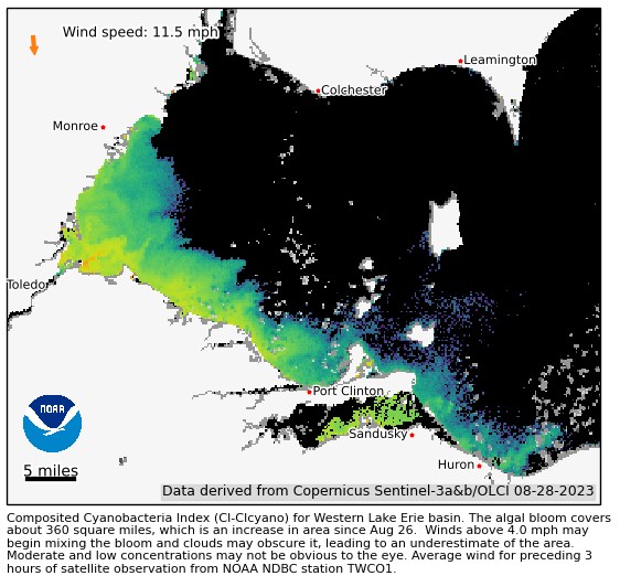
Erie HAB expands east to Vermilion River outlet
National Centers for Coastal Ocean Science is part of the National Oceanographic and Atmospheric Administration (NOAA). The NCCOS image from August 28 (above) shows the blooms from Maumee Bay and Sandusky Bay have rejoined and expanded eastward all the way to the outlet of the Vermilion River. The National Weather Service posts a forecast for both the position and concentration of the Lake Erie HAB from water current data from the Lake Erie Operational Forecast System (LEOFS) combined with NCCOS monitoring imagery and color analysis.
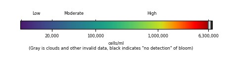
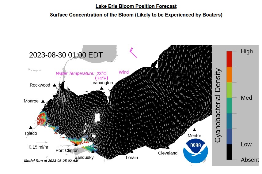
"Potential for bloom movement is forecast in 3-dimensions using a hydrodynamic model with the satellite imagery. The modeled output does not contain clouds. Black coloring indicates the absence of chlorophyll and grey indicates areas with no data. Water temperatures and winds (in magenta) are the averages for the western basin from the model." Lake Erie HAB Forecast update Aug 25-23 "The Microcystis cyanobacteria bloom in western Lake Erie has an approximate area of 360 square miles, which is unchanged from Aug 16. Elevated winds and cloud cover have prevented clear satellite imagery in recent days. As of 8/19, the bloom extends from Monroe, MI to Huron, OH and into the western basin towards Kelleys Island, OH. Highest concentrations are observed in the nearshore waters from Maumee Bay to east of Magee Marsh Wildlife Area. Sandusky Bay has a local bloom of mixed cyanobacteria. Toxins have been detected below the recreational limit. They can be highly concentrated in scums! If you see scum, keep your pets and yourself out of the water. In the satellite imagery or bloom forecast position products, any areas that are orange or red are likely to have scum, especially during calm winds, see Mixing Forecast product. --A. Hounshell 8/25/2023. The past few days of imagery can be seen at the HAB monitoring site. The Lake Erie Forecast is operated by the National Centers for Coastal Ocean Science. Contact hab@noaa.gov for technical questions. Last Updated: 2023-08-25 08 AM EST Raw water Total Microcystins test results this week from Ohio Drinking Water Watch:
Background: The Lake Erie HAB began in Maumee Bay and Sandusky Bay in early July. The Maumee Bay mass has been shifting outward up the Michigan shoreline and eastward along the Ohio shoreline, the two widespread blooms having merged around the Bass and Kelleys islands during the week of August 16. Dr. Stumpf says of the 2023 HAB season, "It's in the middle. So there are worse and better years. The bloom so far has tended to stay on the Ohio coast. It's a bit more common for "half" of it to go up the Michigan coast, and then be carried offshore around the Detroit river plume. This is likely a result of difference in wind patterns this year." Stay tuned here for updates, visit our map or sign up for HABs alerts to your mobile device. NCCOS is an agency of the National Oceanic and Atmospheric Administration. NCCOS provides harmful algal bloom forecasting for certain water bodies and regions including West Basin Lake Erie and Lake Pontchartrain in Louisiana with images from the EUSAT Copernicus-3a satellite. |

| WT Canada Mexico USA: New York Georgia Louisiana Ohio California |
|
All rights reserved 2024 - WTOH - This material may not be reproduced in whole or in part and may not be distributed, publicly performed, proxy cached or otherwise used, except with express permission. |